Photos and text originally by Emily Becker on Climate.gov.
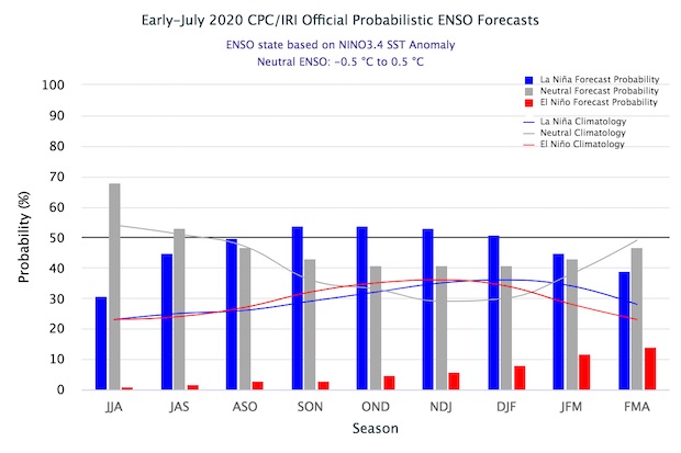
ENSO is still in neutral, and likely to continue so through the summer. However, the 50-55% chance of La Niña developing in the fall and lasting through winter means NOAA has hoisted a La Niña Watch.
What’s a Watch?
I’ve been writing these blog posts for more than six years now, and the terminology La Niña Watch still makes me picture someone peering out their window, binoculars trained on the horizon, waiting for La Niña to pop up. That wouldn’t be a great use of your time, though, as a Watch means the forecast favors the development of La Niña conditions within the next six months. (Also, of course, La Niña—just like El Niño—is a seasonal ocean/atmosphere pattern that develops in the tropical Pacific Ocean, so it might be tough to see it from your window!)
The point of a La Niña Watch is to give planners for energy, agriculture, disaster management, and other sectors a heads-up that the chance of La Niña developing is greater than the combined chance of neutral and El Niño. La Niña changes global atmospheric circulation and influences global weather and climate, so if La Niña develops, seasonal average temperature and rainfall patterns may be more predictable.
Why a Watch?
The current forecast, a 50-55% chance of La Niña, is not a very strong probability. There is still about a 40-45% chance that neutral conditions will remain through the fall and winter, and a smaller but non-zero chance of El Niño—around 5-10%.

The official CPC/IRI ENSO probability forecast, based on a consensus of CPC and IRI forecasters. It is updated during the first half of the month, in association with the official CPC/IRI ENSO Diagnostic Discussion. It is based on observational and predictive information from early in the month and from the previous month. Image from IRI.
These probabilities reflect forecasters’ thinking about current conditions in the tropical Pacific and the computer model guidance. For the past few months, many of the dynamical computer models have been pointing to cooler-than-average conditions on the surface of the tropical Pacific Ocean. These models start from observed ocean and atmosphere conditions and apply physical equations to create a picture of potential future conditions. We consider many different models, and run them many times, to generate a range of potential outcomes that is as complete as possible.
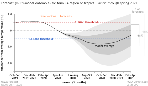
Right now, most of these models predict that sea surface temperatures in the Niño3.4 region will be more than 0.5°C cooler than the long-term average—the La Niña threshold—in the fall and winter, although there is still a wide range of potential outcomes.

We’re finally past the spring predictability barrier, a time of year when climate models are less successful at predicting how the surface temperature of the Pacific will evolve. Forecasts made in July have a good track record of predicting the Niño3.4 index in the late fall and winter, so forecasters increasingly put more weight on them.
Woo, waves
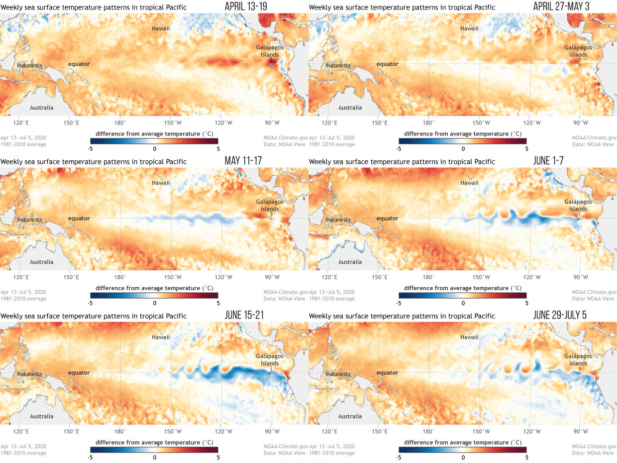
Of course, forecasters also look at the current ocean and atmospheric conditions in the tropical Pacific for signs of how ENSO will develop. Sea surface temperature anomalies (anomaly = difference from the long-term average) in the east-central Pacific, which were slightly positive through much of the winter and spring, are currently slightly negative.

The wavy pattern in the cooler-than-average region is caused by tropical instability waves, a common feature in the eastern Pacific, especially during the second half of the year. The surface water along the equator in the eastern Pacific is usually cooler than the water just to the north and south, as you can see in the temperature (not anomaly) map. This “cold tongue” is caused by cold water rising up from the deeper ocean. The tropical instability waves are the cooler equatorial surface water mixing with the warmer off-equatorial surface. You can find more about tropical instability waves in the second half of this post.
We’re watchful
One of the factors restraining the probability of La Niña in the current forecast is the lack of a substantial source of cooler-than-average water under the surface of the tropical Pacific. Subsurface temperatures are near average in the central Pacific, with some cooler-than-average water remaining in the east, as the upwelling Kelvin wave of the past couple months dissipates. The relatively conservative 50-55% chance of La Niña in part reflects this current absence of a large source of cooler water to supply the surface in the near future.
There are some indications that the trade winds in the central Pacific will strengthen over the next week or so. If this happens, it could help to cool the surface further and possibly initiate another upwelling Kelvin wave. However, this sequence of events is far from guaranteed, as winds are very difficult to forecast more than about 10 days into the future. We’ll keep our binoculars trained on the tropical Pacific, so you don’t have to!