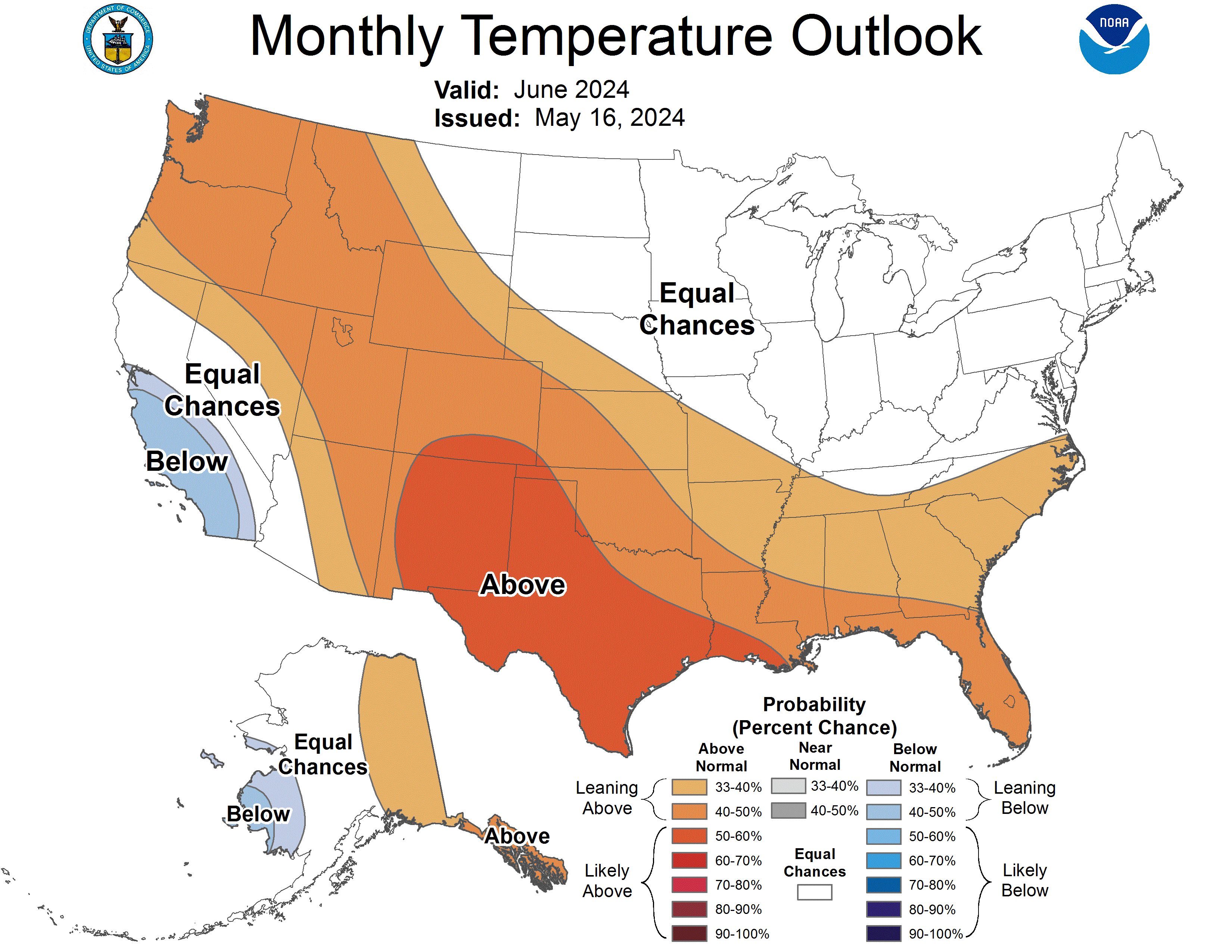
Earlier this week, the NOAA released its monthly outlook for June 2024. Below is an AI-generated summary for those unfamiliar with meteorological terminology and the full discussion further down for those who are!
TL;DR: The June 2024 outlook favors above-normal temperatures for the western and southern U.S., with drier conditions in the Southwest and Pacific Northwest. The central Plains to mid-Atlantic region is expected to see above-normal precipitation.
Temperature Outlook
Above normal temperatures favored for:
- Eastern Alaska to Pacific Northwest and northern Rockies
- Southwest U.S. and eastward to southern Plains and Southeast
- Highest odds in eastern Southwest and Texas due to ridging, dry conditions, and warm trends
Below normal temperatures favored for:
- Coastal central and southern California
- Parts of southwest Alaska
Equal chances for above, near, or below normal temperatures in:
- Midwest, Ohio Valley, and mid-Atlantic regions
Precipitation Outlook
Above normal precipitation favored for:
- Central Plains eastward across Ohio Valley to mid-Atlantic
- Far east-central mainland Alaska
Below normal precipitation favored for:
- Eastern Southwest
- Pacific Northwest and northern Rockies
- Implying later/weaker Southwest monsoon onset
Equal chances across remaining areas due to weak signals or low forecast skill
The outlook considers factors like El Niño-Southern Oscillation (ENSO) conditions, soil moisture, sea surface temperatures, and model guidance.

30-DAY OUTLOOK DISCUSSION FOR JUNE 2024

During the first half of May 2024, the transition from El Nino to ENSO neutral
continues as shown by both oceanic and atmospheric indicators. A further
transition to La Nina remains favored to occur sometime during the summer
months. The MJO is currently not well organized. Although some model forecasts
of the RMM index do indicate some improvement in the signal over the next
couple of weeks, it seems potentially transient in nature with high
uncertainty. Also, given the time within the seasonal cycle, there is low
confidence in any reliable impacts to the U.S. and so the MJO did not play any
substantial role in the monthly outlook. Soil moisture anomalies, coastal sea
surface temperatures (SSTs) and long-term temperature trends  are considered in
preparation of the June 2024 outlook.

The June 2024 temperature outlook depicts elevated odds for above-normal
monthly mean temperatures for a region from eastern mainland Alaska to the
Pacific Northwest and northern Rockies south and east to the Southwest CONUS
and eastward to include the southern Plains and Southeast. Subseasonal model
guidance (ECMWF, GEFS, among others) favors mean ridging for the west-central
CONUS northward across western Canada to eastern Alaska in early June. The
potential ridging elevates odds for warmer than normal conditions for the first
third of June for much of this area with dry soil moisture conditions adding
support for areas in the Pacific Northwest, northern Rockies and parts of the
Southwest and southern High Plains. The majority of the NMME and C3S monthly
model predictions also indicate above-normal temperatures for this region.
Subtropical ridging along the southern tier of the U.S. supports elevated odds
for above-normal temperatures for the southern Plains, Gulf coast and
Southeast. Highest odds are forecast for the eastern Southwest and Texas where
ridging, dry surface conditions and positive long-term temperature trends
co-exist.

Below-normal monthly mean temperatures are favored for two small areas for
coastal central and southern California and also for parts of southwest Alaska.
Cooler than normal ocean surface temperatures contribute to these forecasts
with favored mean forecast troughing near and along the southern half of the
West coast also supporting below-normal temperatures for the California region.

A dipole forecast for enhanced odds for below-normal (above-normal)
temperatures was considered for parts of the Midwest, Ohio Valley and
mid-Atlantic (northern Great lakes and New England) respectively. Conflicting
model forecast guidance, soil moisture conditions and long-term temperature
trends, however, made highlighting these areas in the outlook a low confidence
forecast at the current time. Therefore, Equal Chances (EC) for either above-,
near- or below-normal temperatures is forecast for the mid-month outlook and
reevaluated for the end of the month update.

For precipitation, elevated odds for above-normal monthly total precipitation
amounts are forecast for a region from the central Plains eastward across the
Ohio Valley to the mid-Atlantic. Both subseasonal and monthly model predictions
indicate the tendency for a mean frontal zone in the interior of the CONUS from
the Atlantic seaboard westward to the central CONUS. The location of this
wetter than normal area is quite variable amongst the model solutions so the
forecast area is generally placed in the most likely region after considering
all the available information.

Drier than normal monthly precipitation amounts are forecast for eastern areas
of the Southwest as well as parts of the Pacific Northwest and northern
Rockies. NMME and C3S model monthly predictions are in very good agreement this
month similar to last several monthly forecast cycles for below-normal
precipitation for the eastern Southwest, south-central Rockies and much of
Texas implying a later and/or weaker southwest monsoon onset. Subseasonal model
guidance in early June indicates positive 500-hPa height anomalies in the
northeast Pacific ocean implying a northward shifted storm track and so
elevated odds for below-normal precipitation is forecast in the Pacific
Northwest and northern Rockies. Some NMME and C3S model guidance also supports
this forecast.

Favored forecast ridging in western Canada can sometimes enhance warm season
precipitation for far east-central mainland Alaska so a slight tilt toward
above-normal precipitation is highlighted in this area for June 2024.

Remaining areas depicted in white are forecasts of EC for either above-, near-
or below-normal precipitation amounts due to weak climate signals  and/or low
historical forecast skill or reliability.

FORECASTER: Jon Gottschalck