The NOAA just released its outlook for March 2025.
TL;DR: March 2025 looks promising for the Pacific Northwest and Alaska, with above-normal precipitation and below-normal temperatures expected. However, the Southwest and southern regions may face challenging conditions due to warmer temperatures and less snowfall. Resorts in the Rockies, Northern Plains, and Northeast should prepare for variable conditions, as the forecast remains uncertain for these areas.
Here’s a summary of the outlook, with the full-text discussion at the bottom:
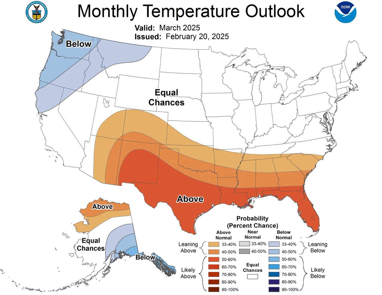
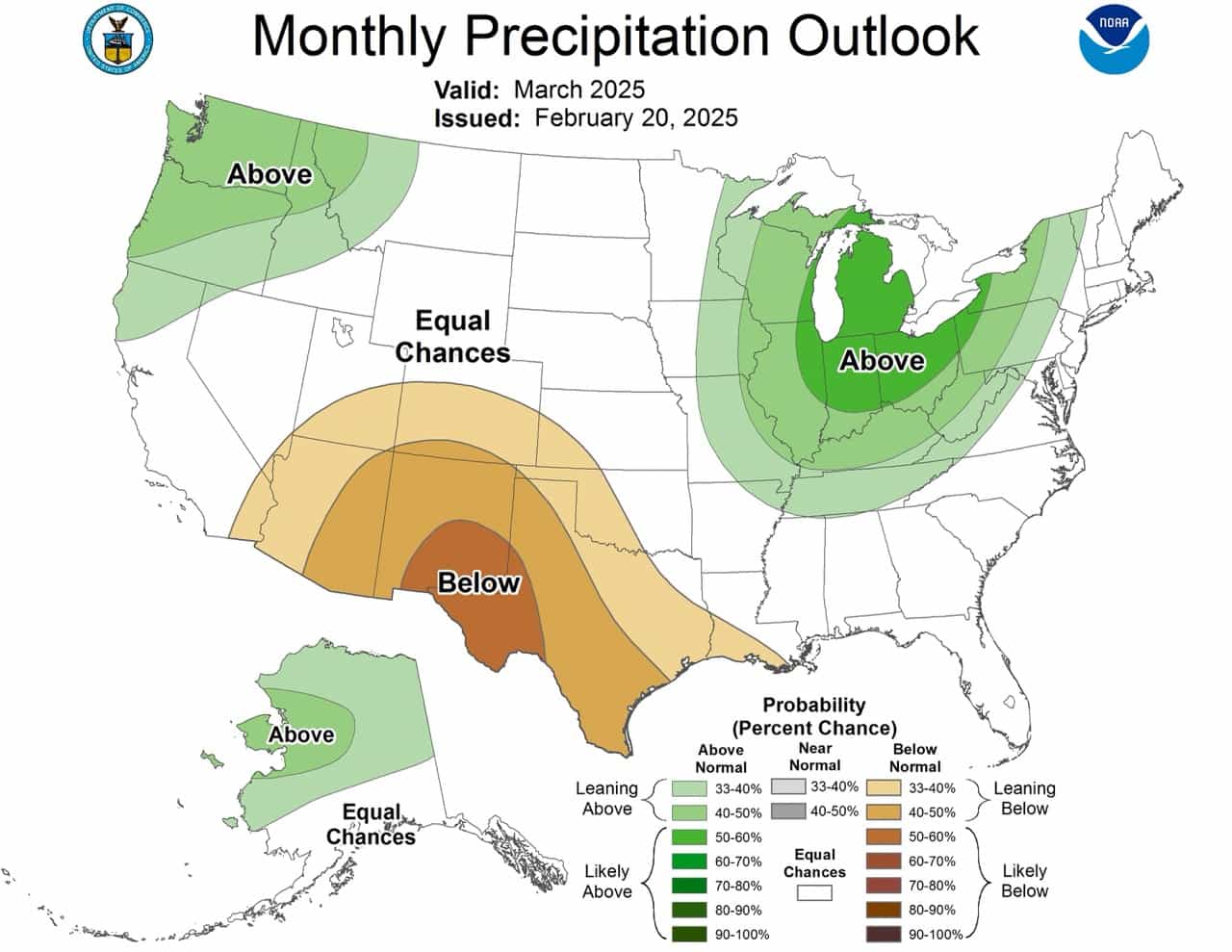
Pacific Northwest and Alaska
Precipitation: Above-normal precipitation is expected for much of the Pacific Northwest and mainland Alaska. This bodes well for ski resorts in these areas, potentially bringing significant snowfall.
Temperature: Below-normal temperatures are forecast for southeastern Alaska and the Northwest. This combination of increased precipitation and colder temperatures should create excellent skiing and snowboarding conditions in these regions.
Southwest and California
Precipitation: Below-normal precipitation is indicated for the Southwest. This could lead to less-than-ideal natural snow conditions for ski resorts in this area.
Temperature: Above-normal temperatures are expected in the Southwest. Ski resorts in this region may need to rely more heavily on snowmaking capabilities.
Rocky Mountains and Northern Plains
Precipitation: There’s more uncertainty for the Northern Plains, with equal chances of above, near, or below-normal precipitation.
Temperature: The forecast shows equal chances of above, near, or below-normal temperatures for the Central and Northern Plains. This uncertainty makes it difficult to predict ski conditions for resorts in these areas.
Great Lakes and Northeast
Precipitation: Above-normal precipitation is favored for the Great Lakes region extending towards the Southeast. This could translate to good snowfall for ski resorts in the area, especially those at higher elevations.
Temperature: There’s uncertainty in the temperature forecast for the northern half of the East Coast, with equal chances of above, near, or below-normal temperatures. Ski resorts in this region should prepare for variable conditions.
Southern Tier
Precipitation: Below-normal precipitation is expected for the Southern Plains and western Gulf Coast.
Temperature: Above-normal temperatures are indicated for much of the southern tier. This combination suggests challenging conditions for any ski areas in these southern regions.
Overall, the Pacific Northwest and Alaska appear to have the most promising outlook for March 2025 skiing and snowboarding. The Southwest and southern regions may face more challenges due to warmer temperatures and less precipitation. Resorts in the Rockies, Northern Plains, and Northeast should prepare for variable conditions given the uncertainty in the forecast.
Prognostic Discussion for Monthly Outlook
NWS Climate Prediction Center College Park MD
830 AM EST Thu Feb 20 2025


30-DAY OUTLOOK DISCUSSION FOR MARCH 2025

A number of extratropical drivers are present that may impact the March 2025
temperature and precipitation patterns over the U.S. La Niña conditions
continue in the Equatorial Pacific, and sea surface temperature (SST) anomalies
were -0.3 degrees Celsius below normal in the Niño3.4 region during the past
week, and reached -0.7 degrees Celsius below normal in the Niño4 region. La
Niña conditions are expected to persist in the near term before transitioning
to El Niño Southern Oscillation (ENSO) neutral during the spring. In addition
to the potential La Niña impacts, the Madden Julian Oscillation (MJO) may have
some bearing on the forecast. There has been coherent MJO activity since the
beginning of 2025, and though dynamical model forecasts of the Realtime
Multivariate MJO (RMM) index for the short term favor a slowed and erratic
evolution of the MJO signal due to a strong equatorial Rossby wave, eastward
propagation is forecast to resume near the beginning of March. Finally, the
Arctic Oscillation (AO) is forecast to become positive in the last week of
February, though this is followed by forecasts of a sharp drop to near neutral
to start the month of March, which may lead to a more transient pattern to
start the month. Though we expect some lingering impacts of the La Niña through
the month of March, these other noted influences are also considered for the
March 2025 Temperature and Precipitation Outlooks, which may modify the
canonical La Niña pattern.

Short term Outlooks through the end of February depict a progressive flow
pattern. In the mean, the mid-level flow pattern favors ridging over the west
and neutral to below normal 500 hPa heights over the East, which leads to a
warm end to February over the western half of the Contiguous United States
(CONUS). However, the mid-level height pattern is expected to be progressive as
we end the month of February and move into early March. As March begins, the
mid-level height pattern is forecast to weaken and retrograde, leading to
variable heights over the East and below normal heights eroding away the
ridging over the western half of the CONUS. This appears to continue into the
Weeks 3-4 Period (through Mid-March), and models forecast troughing over the
Northern part of the CONUS and Alaska, and ridging over the South. However,
there is considerable uncertainty of the extent of troughing into the lower 48
with some models containing the below normal heights more to the North over
Canada, and others depicting it reaching further South. This leads to
uncertainty over the northern third of the CONUS particularly for temperature.

The March 2025 Temperature Outlook favors below normal temperatures over
southeastern Alaska and the Northwest. Above normal temperatures are indicated
over northern Alaska and from the Southwest to the Southeast. This somewhat
resembles a typical La Niña teleconnection pattern for March, which would bring
below normal temperatures to southern Alaska and the northern tier of the CONUS
and above normal temperatures to the South, as well as monthly CFSv2 forecasts
of temperatures. Multi-Model Ensemble forecasts of monthly temperatures, such
as the North American Multi-Model Ensemble (NMME) and Copernicus Climate Suite
(C3S), support the below normal temperatures over southeastern Alaska and the
Northwest, but tilt toward above normal temperature probabilities over the
eastern two-thirds of the CONUS, including the Northern Plains and New England.
However, given the progressive but below normal 500 hPa height pattern expected
in the beginning of March and differences in the southward extent of the
mid-level height pattern in week 3-4 models, Equal Chances (EC) of above, near,
and below normal temperatures are favored for the Central and Northern Plains
to the northern half of the East Coast where there is higher uncertainty and
models differed. Probabilities of below normal temperatures are enhanced where
the impact of La Niña, cooler temperatures possible from MJO, and where the
trough that is expected to retrograde in early March are expected to lead to
below normal temperatures. In contrast, above normal temperatures are indicated
over much of the southern tier, and are (relatively) stronger. Models and tools
support the probabilities of above normal temperatures along the South, as does
the typical La Niña teleconnection and mid-level ridging that is comparatively
more stationary.

Tools were comparatively more consistent when considering the precipitation
pattern over the U.S. for March. As has been fairly common the last few months,
models tend toward a La Niña like pattern for precipitation, which is found in
most models. This is very apparent in NMME and C3S, which broadly favor weak
above normal precipitation over central and northern Alaska, the Northwest, and
Great Lakes to the northern parts of Gulf States, and below normal
precipitation over the South coast of Alaska, the Southwest, Southern Great
Plains, and western Gulf Coast. The March Precipitation Outlook also broadly
favors this pattern, indicating above normal precipitation over much of
Mainland Alaska, the Northwest and Great Lakes to Southeast and below normal
precipitation over the Southwest and Southern Plains, but there are some
differences given expected intra-month variability. In particular, equal
chances of above, near, and below normal precipitation are favored over the
South coast of Alaska given short term forecasts for above normal precipitation
that may outweigh the below normal signal. Similar arguments are in place for
the Gulf Coast, which is typically below normal during La Niña, but is
appearing to be more variable in the shorter term forecasts, thus EC is favored
for the eastern Gulf Coast. EC is also favored over the Northern Plains,
despite some models such as CFSv2 indicating weak chances of above normal
precipitation, due to uncertainty in remaining tools and relatively stronger
signals over the Northwest and Great Lakes.


FORECASTER: Johnna Infanti

The climatic normals are based on conditions between 1991 and 2020, following
the World Meteorological Organization convention of using the most recent 3
complete decades as the climate reference period.  The probability anomalies
for temperature and precipitation based on these new normals better represent
shorter term climatic anomalies than the forecasts based on older normals.

An updated monthly outlook... for Mar will be issued on Fri February 28 2025

These outlooks are based on departures from the 1991-2020 base period.
$$