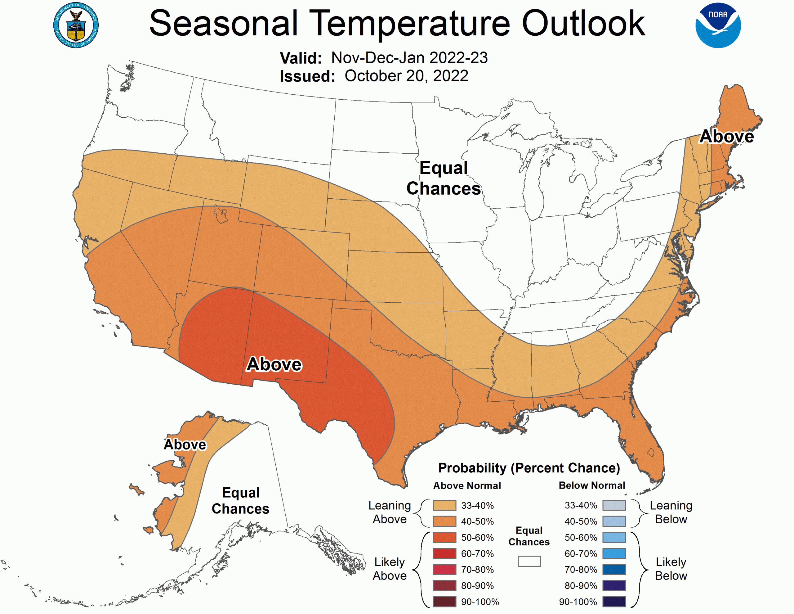
The November-December-January 2022-2023 temperature outlook depicts elevated odds for above-normal seasonal mean temperatures for western Alaska, much of the western U.S. to include the central Great Basin, central and southern Rockies, and Southwest, eastward to include much of the central and southern Great Plains, areas of the Southeast and along the Atlantic seaboard. The greatest likelihood for warmer than normal temperatures is for the Southwest and southern Great Plains.
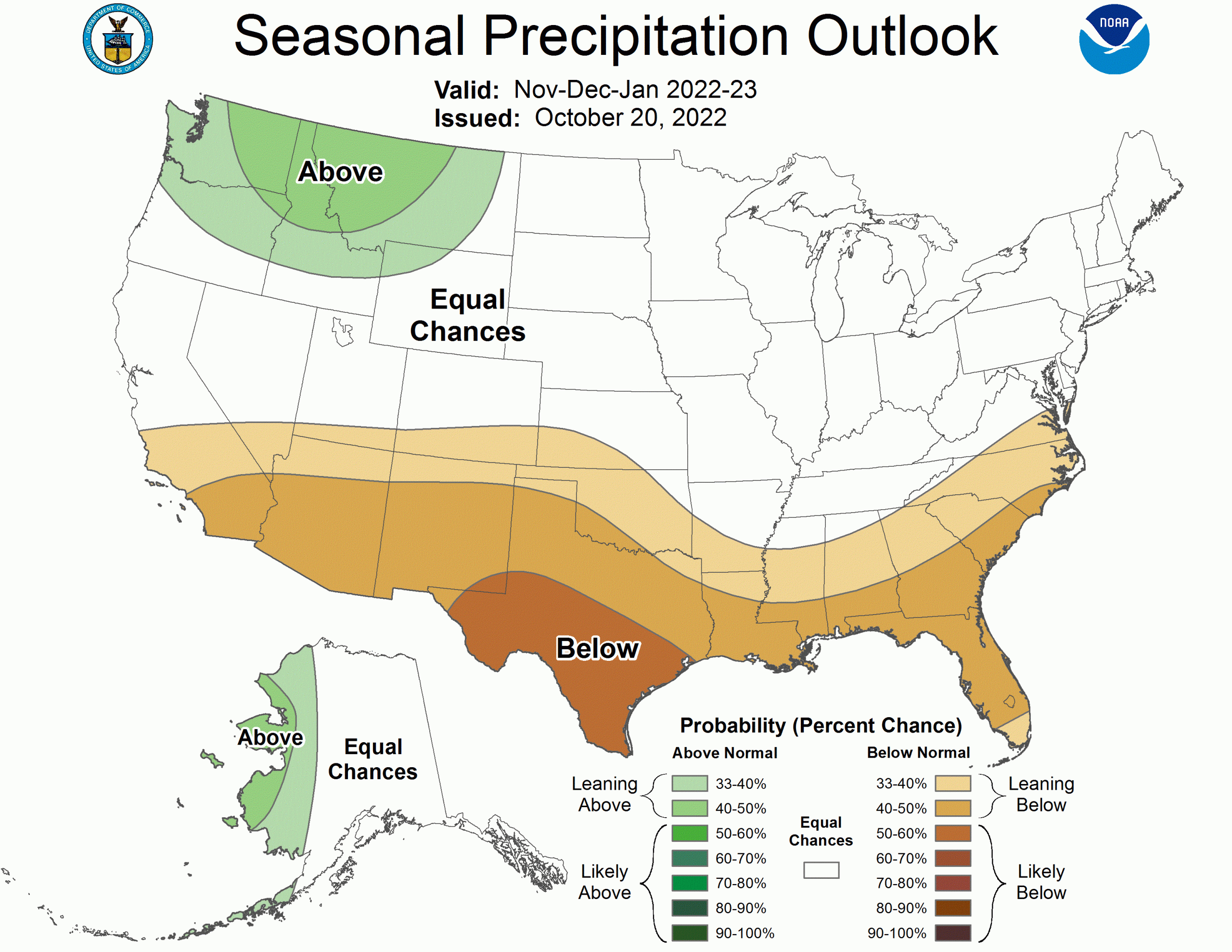
For precipitation, above-normal seasonal precipitation amounts are favored for the west coast of Alaska, the Pacific Northwest, and the northern Rockies. Drier-than-normal conditions are most likely along the southern tier of the U.S. from California eastward to the southern Plains and Southeast with the greatest likelihood for southern Texas.

Areas depicted in white and labeled “EC” (Equal-Chances) are regions where climate signals are weak and so there are equal odds for either above-, near- or below-normal seasonal mean temperatures and total precipitation amounts.
La Nina conditions remain in place in the Pacific Ocean and its influence continues to contribute to the temperature and precipitation outlooks through the upcoming winter months into early Spring 2023.
The full discussion is below:
PROGNOSTIC DISCUSSION OF OUTLOOKS - NDJ 2022 TO NDJ 2023

TEMPERATURE

The NDJ 2022-2023 temperature outlook favors above-normal temperatures for much
of the western U.S. eastward to include much of the central and southern Great
Plains, areas of the Southeast and also along the Atlantic seaboard. The
expectation of La Nina conditions and enhanced odds for associated
common impacts - on average over many events - is a primary driver of the
evolution of the temperature outlooks from NDJ 2022-2023 through the MAM 2023
lead. Multiple types of guidance was utilized for this assessment and included
La Nina composites, ENSO regression / correlation information, statistical
forecast tools and dynamical model forecasts.

Although some of the participant models within the NMME and C3S suite
maintained the colder signature starkly shown in last month's data typically
associated with La Nina in areas of Alaska, Canada and the northern U.S., in
general, the NMME overall ensemble mean probabilities are considerably warmer
in this month's set of forecasts. For many of these areas in the U.S. and
southern Canada, however, calibration based on historical forecast skill
dramatically decreased probabilities and so confidence is low. Moreover,
further inspection of 200-hPa height information from the NMME suite indicated
that anomalous positive heights forecast at higher latitudes last month are
reduced in this months forecast with a weaker mean Hudson Bay trough in the
warmer NMME solutions. This strongly hints at a considerable change in the
forecast AO phase over the winter months. Predictability of the seasonal AO
phase is low. Given the reasons and associated uncertainty noted above, along
with large areas of positive SST anomalies in both the north Pacific and
Atlantic, incorporated in the CA statistical guidance, there was not
significant changes at this time to the favored below-normal temperature
forecast evolution from DJF 2022-2023 through MAM 2023 despite the warmer
overall NMME solution this month.

The official outlooks over time increase coverage of below-normal temperatures
for the Pacific Northwest eastward to the northern Plains and western Great
Lakes in DJF 2022-2023 and JFM 2023 and relax this area northward (less
coverage and lower probabilities) in FMA and MAM 2023.

A forecast for elevated odds of overall colder conditions for the Northeast is
implied in the outlooks from NDJ 2022-2023 through FMA 2023. La Nina events are
often characterized by high subseasonal variability especially for the
north-central CONUS, Ohio Valley and Northeast as these areas are strongly
impacted by variations in the AO/NAO and potential stratospheric influences
(typically more likely during the second half of winters) - all of which are
very difficult to reliably predict at these lead times. Consequently, the
coverage of Equal-Chances (EC) is large in some of these areas from JFM to MAM
2023.

The greatest odds for above-normal temperatures slowly shifts from the
Southwest to the Southeast over the period from NDJ 2022-2023 to FMA 2023 with
a minimum in both probabilities and coverage in the southern Plains during the
JFM 2023 season.

For Alaska, enhanced chances for below-normal temperatures for southeast Alaska
and the Alaska Panhandle are introduced in DJF 2022-2023 and maximize in JFM
2023 before decreasing and timing off after MAM 2023. Anomalously positive
ocean surface temperatures tilt the odds for above-normal temperatures for
parts of the west coast of Alaska through JFM 2023.

Odds for favored above-normal temperatures are increased for the south-central
southern Plains during MAM, AMJ and MJJ 2023 from the previous set of outlooks
due to severe drought conditions currently ongoing and with the prospects for
below-normal winter precipitation. If realized, this increases odds for
above-normal temperatures during the spring and early summer months.

The remaining set of temperature outlooks remain generally the same from the
September release and are based on the ENSO/OCN and other consolidation
forecast tools for which long term temperature trends  contribute significantly
at times in various regions.

PRECIPITATION

For the NDJ 2022-2023 precipitation outlook, above-normal seasonal
precipitation amounts are most likely for the west coast of Alaska, the Pacific
Northwest and northern Rockies. Drier-than-normal conditions are most likely
for
the southern tier of the U.S. from southern California eastward to the southern
Plains and Southeast.

Similar to that described above for temperature, the evolution of the
precipitation outlooks through MAM 2023 are anchored to first order from
potential typically observed impacts during La Nina winters - on
average over many events. The greatest odds for below-normal precipitation
during NDJ and DJF 2022-2023 are positioned primarily for southern Texas.

In addition, consolidation of both statistical and dynamical model guidance
(NMME, C3S) modified the base state La Nina favored impacts and this approach
was primarily followed in the outlooks through MAM 2023. Long term
precipitation trends , especially positive (more wet) trends  in numerous areas
in the Midwest and eastern CONUS, contributed to the outlooks over this
forecast period as well. The later set of outlooks are primarily based on long
term precipitation trends .