The NOAA just released its outlook for November. In this month, when many ski resorts typically open, will Mother Nature cooperate and give us the season start we crave?
Here’s a short summary of the outlook for those only interested in the cold and snow!
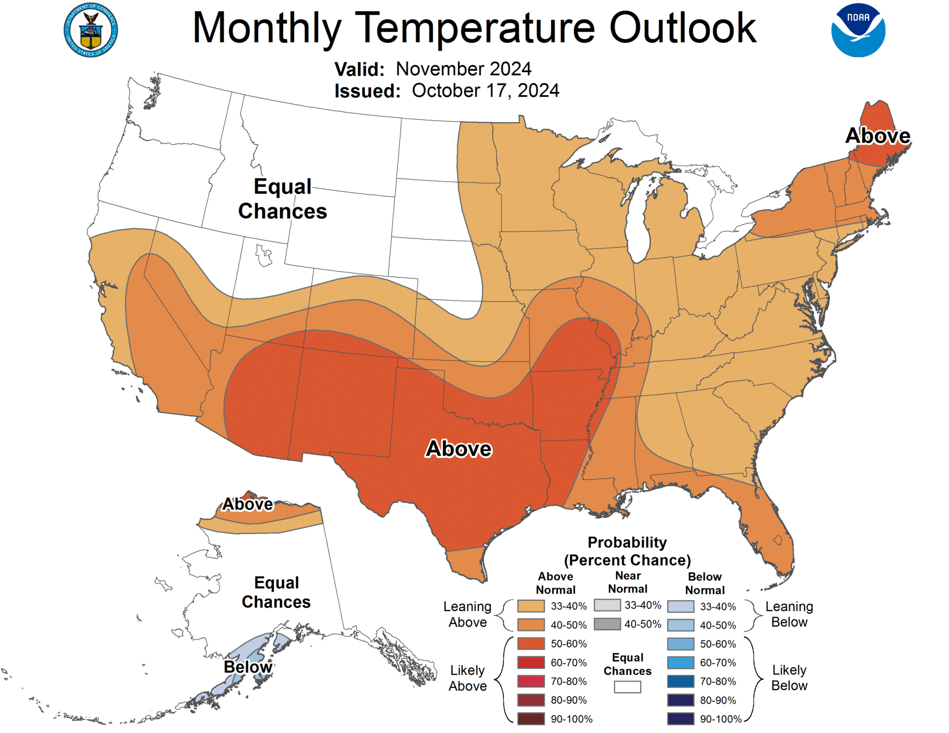
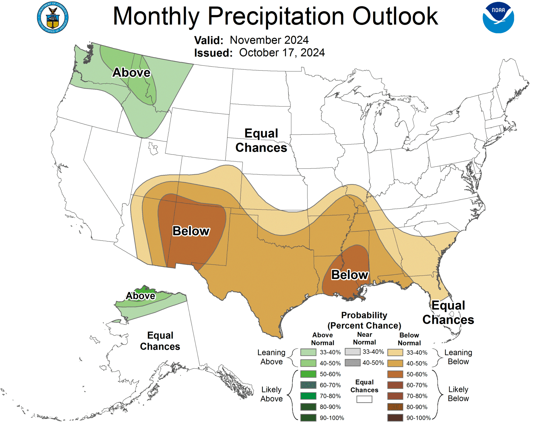
Pacific Northwest: The temperature outlook shows less certainty, but there are indications of above-normal precipitation, which could benefit early-season snowfall.
Northern Great Plains: Similar to the Pacific Northwest, the temperature outlook is uncertain, with the potential for colder conditions.
Alaska:
- North Slope and Northwest Coast: Likely to experience above-normal temperatures due to warmer sea surface temperatures and lower sea ice.
- Kenai Peninsula to Alaska Peninsula: Slightly elevated chances for below-normal temperatures, though this is weakly supported by models.
Southern U.S.: The forecast suggests below-normal precipitation across most areas, hindering snow accumulation and early skiing conditions.
Northern Alaska: Expect above-normal precipitation, typically associated with warmer sea surface temperatures and lower sea ice, which could lead to favorable conditions for snowfall.
In summary, the Pacific Northwest and parts of Alaska appear to be the most promising regions for skiing and snowboarding in November 2024, while southern areas may face challenges due to below-normal precipitation.

Full NOAA discussion below:
30-DAY OUTLOOK DISCUSSION FOR NOVEMBER 2024

The November 2024 outlook considered the current and projected state of El Niño
Southern Oscillation (ENSO), the Madden Julian Oscillation (MJO), trends , and
recent Sea Surface Temperatures (SSTs). Tools considered are the Sea Surface
Temperature Based Constructed Analog (SST-CA), Canonical Correlation Analysis
(CCA), Optimal Climate Normals (OCN), ENSO-OCN blend, and the dynamical models
in both the North American Multi-model Ensemble (NMME) and Copernicus Climate
Change Services (C3S) suites. Of note, soil moisture was not considered due to
the waning influence at this time of year. Further, precipitation measurements
over Ontario Canada were deemed unreliable so they were not considered in the
analysis of tools for the precipitation outlook.

The temperature outlook is close to the consolidation of the statistical tools
and NMME, though notably shifted toward a less certain outlook in the Pacific
Northwest and Northern Great Plains. The likely progression of the MJO and
associated downstream impacts, combined with some analyses showing an
over-amplified trend in the many of the dynamical models , leads to less
certainty in the Pacific NorthWest and Northern Great Plains. Uncertainty about
the temperature outcomes along the mid-Atlantic resulted in lowered
probabilities there compared to the final consolidation, as the tools indicate
either near- or above-normal temperatures. The only tool indicating
below-normal temperatures is a soil moisture based constructed analog, which
was not considered due to the time of year. Recent SST changes toward warmer
temperatures and climatologically low sea ice favor above-normal temperatures
across the North Slope and northwest coast of Alaska. Slightly elevated odds
for below-normal temperatures from the Kenai Peninsula to the Alaska Peninsula
are consistent with La Niña though only weakly supported in the dynamical
models.

The precipitation outlook reflects the consistent signals  among the tools and
dynamical models. Favoring below-normal precipitation along most of the
southern tier is related to the developing La Niña, as well as indicated in
most of the tools and dynamical models . The CFS indicates some wetness across
the Southern Plains, so probabilities there are lower than the Southwest and
the Lower Mississippi Valley. Statistical tools also indicate above-normal
precipitation in Kansas and Oklahoma but the dynamical models  do not, and
calibrations result in very small and uncertain areas. Across the Pacific
Northwest, the forecast for above-normal precipitation is supported in the
dynamical models (NMME and C3S) and aligns with the emerging La Niña.
Above-normal precipitation across Northern Alaska is typically associated with
warmer SSTs and lower sea ice. Almost all of the models in the NMME suite have
a signal for above-normal precipitation across the north slope, which is
retained in the calibrated outlooks.

FORECASTER: Matthew Rosencrans

The climatic normals are based on conditions between 1991 and 2020, following
the World Meteorological Organization convention of using the most recent 3
complete decades as the climate reference period.  The probability anomalies
for temperature and precipitation based on these new normals better represent
shorter term climatic anomalies than the forecasts based on older normals.
One thought on “NOAA November 2024 Outlook: Above-Normal Temperatures to Impact Opening Days Across the Country”