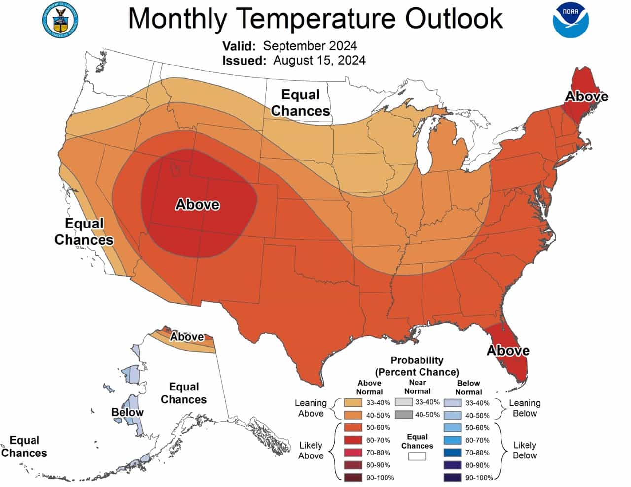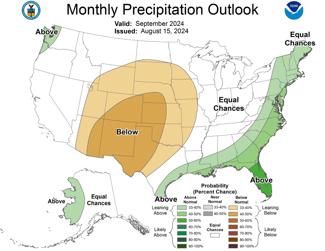
With September comes fall, meaning ski season is not far away. In the past few years, some resorts have begun snowmaking towards the end of September. For those of you yearning for cooler days, here is the September outlook, according to the NOAA.
TL;DR: The September 2024 weather outlook predicts above-normal temperatures across most of the U.S., with notable warmth in the West and Northeast. Precipitation patterns suggest wetter conditions along the Gulf and Atlantic coasts, while drier weather is expected in the western and central regions. Alaska will see a mix of cooler temperatures in the west and warmer conditions in the north, with some areas experiencing increased precipitation.
Northeast U.S.
- Temperature: Due to warmer sea surface temperatures and strong decadal trends, above-normal temperatures are expected, particularly in northern New England.
- Precipitation: Above-normal precipitation is likely along the Atlantic Coast up to Maine, influenced by an active tropical cyclone season.
Southeast U.S.
- Temperature: Above-normal temperatures are anticipated for the Florida Peninsula, driven by warm adjacent sea surface temperatures.
- Precipitation: Above-normal precipitation is favored along the Gulf Coast, supported by active tropical cyclone activity forecasts.
Midwest U.S.
- Temperature: Most areas are expected to experience above-normal temperatures.
- Precipitation: Below-normal precipitation is predicted for the Central Mississippi Valley.
West U.S.
- Temperature: Above-normal temperatures are likely, especially from the Four Corners region to the eastern Great Basin and central Rockies, with a high probability exceeding 60%.
- Precipitation: Below-normal precipitation is expected from the southwest desert to the high plains of Montana.
Pacific Northwest U.S.
- Temperature: Equal chances of below-, near-, and above-normal temperatures due to moderated sea surface temperatures.
- Precipitation: Slightly favors above-normal precipitation along the coast, potentially influenced by early La Niña impacts.
Alaska
- Temperature: Below-normal temperatures are expected along the west coast of mainland Alaska, while above-normal temperatures are likely along the North Slope.
- Precipitation: Above-normal precipitation is slightly favored for parts of western mainland Alaska.

Here’s the full discussion from the NOAA:
30-DAY OUTLOOK DISCUSSION FOR SEPTEMBER 2024

The September 2024 monthly temperature and precipitation outlooks are made
under neutral El Niño Southern Oscillation (ENSO) climate conditions. The most
recent weekly Niño 3.4 sea surface temperature (SST) anomaly is at 0.0 degrees
Celsius. SST anomalies for the Niño 3.4 region of the east-central equatorial
Pacific Ocean have remained steady over the last two-to-three months. In recent
weeks, lower level wind anomalies at 850 hPa were easterly over the
east-central and eastern equatorial Pacific Ocean, while upper level wind
anomalies at 200 hPa were easterly over the east-central equatorial Pacific
Ocean and westerly over the eastern equatorial Pacific Ocean. Outgoing longwave
radiation (OLR) anomalies are weak across the equatorial Pacific Ocean,
indicating near-average convection. These ocean and atmosphere conditions
indicate neutral ENSO conditions have persisted. A potential transition to La
Niña conditions is forecast and may be a driver of temperature and
precipitation patterns over North America in the near future and in the
September temperature and precipitation outlooks.

On subseasonal timescales, the Madden Julian Oscillation (MJO) is active in
phase 1 near the threshold of phase 2 with enhanced convection over Africa.
Dynamical model forecasts indicate that the MJO will propagate eastward into
the Indian Ocean and Maritime Continent in the next couple weeks. Lagged
composites indicate that this active MJO would increase temperatures over the
western United States in early September, with potentially cooler temperatures
over parts of the eastern contiguous U.S. (CONUS). Impacts of the MJO were
generally considered in the September monthly outlook through dynamical model
forecasts for the week 3-4 period that overlap with the first half of
September. In addition to the teleconnections over North America, more
favorable conditions for tropical cyclone activity over the Atlantic at the
start of September are predicted.

The September temperature and precipitation outlooks were based primarily on
dynamical model forecasts and a combined consolidation of the statistical and
dynamical model forecasts. Dynamical model forecasts for the month of September
are from the North America Multimodel Ensemble (NMME). In addition, the full
consolidation includes a consolidation of the statistical models: the Canonical
Correlation Analysis (CCA), the Constructed Analog (CA), and an ENSO OCN tool,
that combines the impact of ENSO, based on the CPC SST consolidation predicted
median Niño 3.4 SST anomaly, with the Optimum Climate Normal (OCN) representing
decadal trends . Daily initialized forecasts from the NCEP CFSv2 dynamical model
and the most recent ECMWF and GEFS dynamical model forecasts for the week 3-4
period that overlaps the beginning of the month of September were also
considered. Recent boundary conditions, including coastal SSTs, and soil
moisture anomalies, were additional factors considered.

The September temperature outlook favors below-normal temperatures along the
west coast of Mainland Alaska, consistent with dynamical model guidance from
the NMME including the CFSv2, plus ECMWF and GEFS forecasts for the week 3-4
period ending September 10th, as well as well below average SSTs along the
coast. Above-normal temperatures are likely along the coast of the North Slope,
consistent with well below average sea ice extent and above average SSTs.
Above-normal temperatures are likely across most of the CONUS, supported
primarily by the consolidation of statistical and dynamical forecast tools. The
probability of above-normal temperatures exceeds 60 percent for a large area of
the West from the Four Corners region to the eastern Great Basin and central
Rockies, where dynamical models , statistical models, and decadal trends  all
indicate a strong temperature signal. The probability of above-normal
temperatures exceeds 60 percent for parts of northern New England, where
adjacent SSTs are above average, ECMWF week 3-4 forecasts favor above-normal,
and decadal temperature trends  are strong. Above average adjacent SSTs lead to
a 60 percent probability of above-normal temperatures for the Florida
Peninsula. Equal chances (EC) of below-, near- and above-normal temperatures
are indicated along the central and southern California coast, where
temperatures are moderated by near-to-below average SSTs. EC is also indicated
for parts of the Pacific Northwest along the northern tier into the Northern
Plains and Upper Mississippi Valley, where the PAC-calibrated NMME temperature
forecast shows moderation of probabilities due to lower skill and/or weaker
signals, while the full consolidation forecast predicts near-normal is favored
in some of the same areas.

The September precipitation outlook slightly favors above-normal precipitation
for parts of western Mainland Alaska, supported primarily by dynamical model
forecasts from the NMME. Above-normal precipitation is favored for a small
coastal area of the Pacific Northwest, consistent with the CFSv2 forecast and
possible early impacts of La Niña. Below-normal precipitation is favored over a
large area of the western CONUS from eastern areas of the Desert Southwest
northward to the High Plains of Montana and eastward into much of the Great
Plains and the Central Mississippi Valley, consistent with negative
precipitation anomaly forecasts from the NMME multi-model ensemble mean and
impacts from potential La Niña conditions. Above-normal precipitation is
favored for the entirety of the Gulf Coast and northward along the Atlantic
Coast to Maine, consistent with the peak month of a predicted active Atlantic
tropical cyclone season in addition to favorable conditions for Atlantic
tropical activity at the start of September related to the predicted
propagation of the MJO. The probability of above-normal precipitation exceeds
50 percent for parts of the Florida Peninsula, supported by NMME forecasts for
September.