On Thursday, January 16, the NOAA updated its long-range seasonal forecasts for this winter, giving snow lovers an idea of what the remainder of winter 2025 might hold. Here’s what the NOAA winter 2024-25 forecast looks like:
- Related: Farmers’ Almanac 2024-25 Winter Forecast: Cold, Wet, Snowy Winter Ahead…. But Where?
- Related: [VIDEO] Direct Weather Updated Winter 2024-25 Forecast: Coldest and Snowiest in 10+ Years
- Related: Median Dates for First Measurable Snowfall of the Year in North America
Based on the outlook discussion, here’s the outlook for the rest of winter 2024-25.
La Niña Conditions and Their Impact
La Niña conditions are currently present and expected to persist through February-April (FMA) 2025. This weak La Niña event is characterized by below-average sea surface temperatures in the central and east-central Pacific Ocean. While La Niña typically brings specific weather patterns, the weakness of this event may lead to more variability within the season.
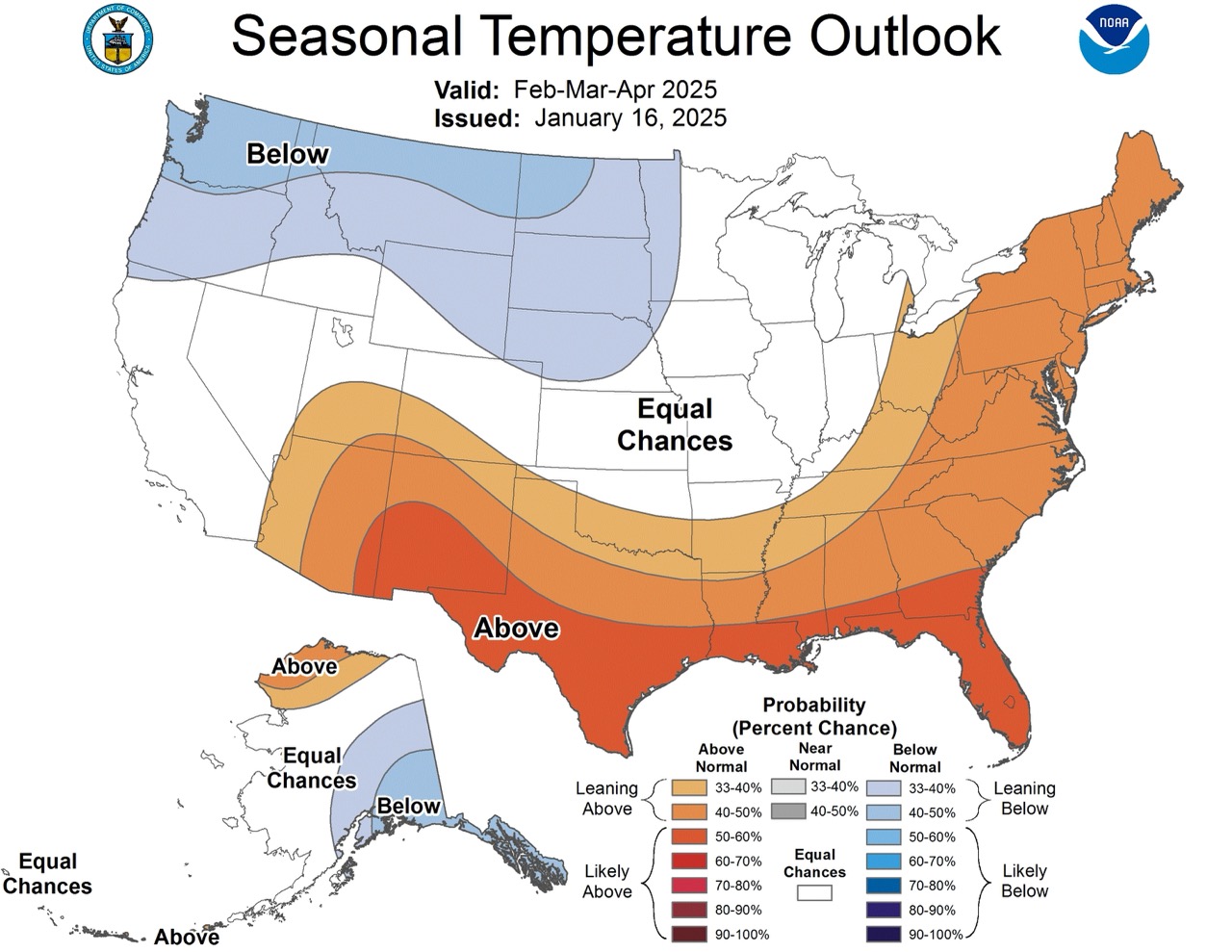
Temperature Outlook
The temperature forecast for FMA 2025 favors below-normal temperatures from the northwestern Contiguous United States (CONUS) to the Northern Plains, as well as southeastern Alaska. This is good news for ski and snowboard enthusiasts in these regions, as colder temperatures can contribute to better snow conditions. Conversely, above-normal temperatures are expected over the southern tier of the CONUS, along the East Coast into New England, and over northern Alaska.
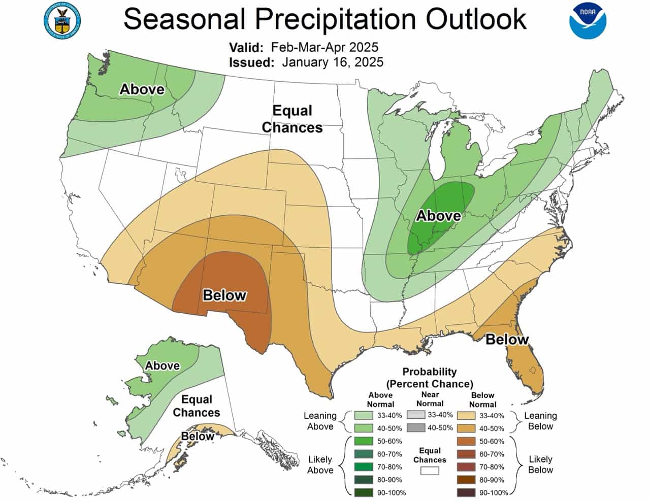
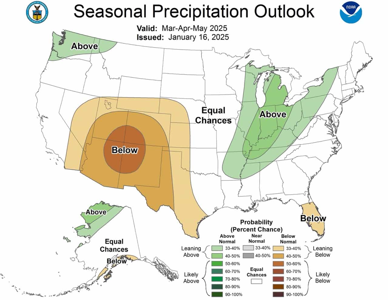
Precipitation Outlook
The precipitation outlook for FMA 2025 is favorable for many ski and snowboard destinations. Above-normal precipitation is forecasted for the Northwest, the Great Lakes, Ohio Valley, parts of the Upper and Middle Mississippi Valley, Interior Northeast, and western and northern Alaska. This increased precipitation could translate to more snowfall in mountainous and northern regions.
However, below-normal precipitation is indicated for the Southwest, Central Plains, the Gulf Coast, and southern Mid-Atlantic. Ski resorts in these areas may face challenges with natural snowfall, potentially relying more on snowmaking capabilities.
Variability and Uncertainty
It’s important to note that the weakness of this La Niña event may lead to more variability within the season. While the overall pattern is expected to follow typical La Niña impacts, there may be periods that deviate from this pattern. Additionally, the forecast for California is less certain, with equal chances of above, near, or below-normal precipitation for much of the state.
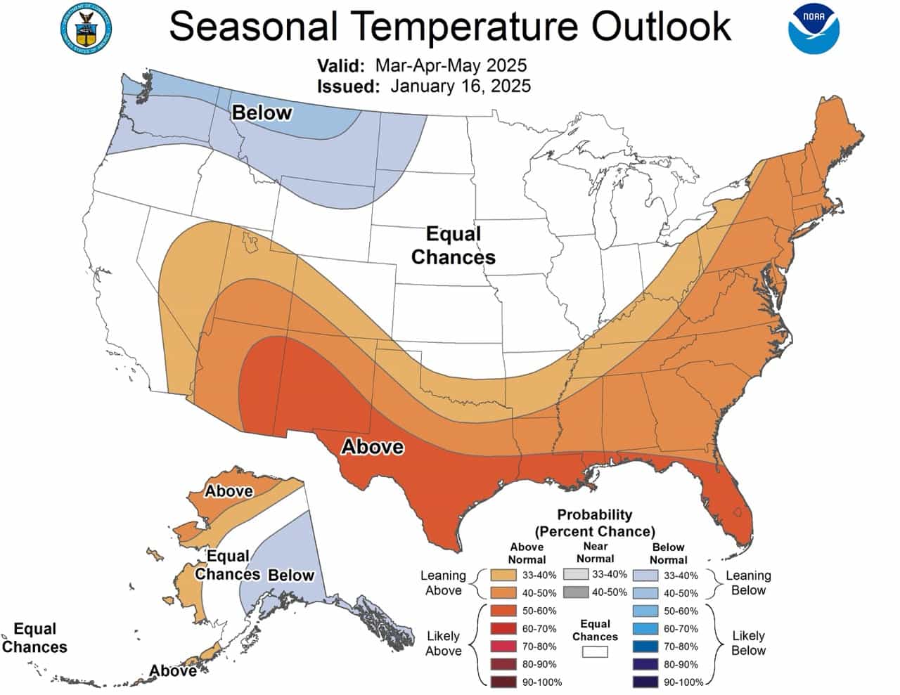
Looking Ahead
As we move into spring and summer 2025, the La Niña influence is expected to wane. However, some lagged impacts may persist through at least the March-May (MAM) season. For winter sports enthusiasts planning far ahead, it’s worth noting that the long-term forecast suggests a return to more neutral conditions, with less certainty in the precipitation and temperature patterns for the 2025-2026 winter season.
Here’s the discussion in full from the NOAA:
Prognostic Discussion for Long-Lead Seasonal Outlooks
N
Prognostic Discussion for Long-Lead Seasonal Outlooks
NWS Climate Prediction Center College Park MD
830 AM EST Thu Dec 19 2024

SUMMARY OF THE OUTLOOK FOR NON-TECHNICAL USERS

El Niño Southern Oscillation (ENSO)-neutral conditions are present, as
equatorial sea surface temperatures (SSTs) are near-to-below average in the
central and eastern Pacific Ocean. During the last four weeks, mostly negative
SST anomaly changes were evident across the equatorial Pacific Ocean. As such,
a La Niña Watch is in effect, with La Niña conditions most likely to emerge in
November 2024 - January 2025 (NDJ) (59% chance) and is expected to persist
through February-April (FMA) 2025. In fact, the latest weekly Nino 3.4 SST
departure was -0.6 degrees Celsius, which technically crosses the La Niña
threshold. However, chances of a strong La Niña are exceedingly small, with a
near zero percent chance of occurrence through the Winter. ENSO-neutral
conditions are favored to re-emerge by the March-May (MAM) 2025 season.

The January-March (JFM) 2025 temperature outlook favors above-normal
temperatures for most of the southern tier of the Contiguous United States
(CONUS), the eastern quarter of the CONUS, and northern Alaska. The largest
probabilities (greater than 50 percent) of above normal temperatures are
forecast across parts of the Southwest, the Rio Grande Valley, the Gulf Coast
Region, and the Southeast. Conversely, a weak tilt toward below normal
temperatures is indicated for southeastern Alaska, the northwestern CONUS, and
the Northern Plains. The JFM 2025 Precipitation Outlook depicts enhanced
probabilities of below-normal precipitation amounts across much of the southern
tier of the CONUS as well as parts of southern Mainland Alaska. The greatest
chances (greater than 50 percent) of below-normal precipitation are forecast
for the Rio Grande Valley and the Florida Peninsula, where probabilities of
below exceed 50 percent. Above-normal precipitation is more likely for the
northwestern CONUS, the Great Lakes, Ohio Valley, parts of the Upper and Middle
Mississippi Valley, parts of the interior Northeast, and much of northern and
western Mainland Alaska. The greatest chance (above 50 percent) of above-normal
precipitation is indicated for the central Great Lakes region and northern
portions of the Ohio Valley. Equal chances (EC) are forecast for areas where
probabilities for each category of seasonal mean temperatures and seasonal
accumulated precipitation amounts are expected to be similar to climatological
probabilities.

BASIS AND SUMMARY OF THE CURRENT LONG-LEAD OUTLOOKS
Note: For Graphical Displays of the Forecast Tools Discussed Below See:
http://www.cpc.ncep.noaa.gov/products/predictions/90day/tools/briefing

CURRENT ATMOSPHERIC AND OCEANIC CONDITIONS

ENSO-neutral continued in November, with near to weakly below average sea
surface temperatures (SSTs) observed across much of the central and eastern
equatorial Pacific Ocean. The latest weekly Niño indices ranged from -0.2°C
(Niño-1+2) to -0.6°C (Niño-3.4), with the magnitude of the negative Niño-3.4
anomaly technically crossing the La Niña threshold. Below-average subsurface
ocean temperatures persisted across the east-central and eastern equatorial
Pacific Ocean. Over the western and central equatorial Pacific, low-level wind
anomalies were easterly and upper-level wind anomalies were westerly.
Convection was suppressed over the Date Line and was enhanced over western
Indonesia. The traditional and equatorial Southern Oscillation indices were
positive. Collectively, the coupled ocean-atmosphere system reflected
ENSO-neutral. However, with SST anomalies across much of the Tropical Pacific
trending more negative, a La Niña Watch remains in effect.

The Madden-Julian Oscillation (MJO) has continued to be a significant player in
the tropics. However, the emerging La Niña base state has been a growing source
of interference with both the propagation and amplitude of the MJO. Dynamical
model forecasts depict continued eastward propagation of the MJO signal with a
slow phase. Extended range Realtime Multivariate MJO (RMM) index solutions
indicate the potential for a surge in the strength of the MJO during weeks 3
and 4 as it moves out into the Central Pacific and La Niña interference
lessens. A continued eastward MJO propagation over the Pacific would favor a
period of below-normal temperatures across the northeastern U.S. to start off
the New Year, as well as a wet start for the West Coast. However, the majority
of seasonal guidance for JFM favors above normal temperatures for the
Northeast, suggesting that this cold period may be short lived.

PROGNOSTIC DISCUSSION OF SST FORECASTS

The dynamical models  in the Columbia Climate School International Research
Institute for Climate and Society (IRI) plume continue to predict a weak and a
short duration La Niña. This prediction is also reflected in the latest North
American Multi-Model Ensemble (NMME), which continues to predict slightly
cooler SSTs and weak La Niña conditions. The ENSO forecast team leaned toward
predicting an eventual onset of weak and short-lived La Niña conditions, based
on the model guidance and current atmospheric anomalies. In summary, La Niña
conditions are most likely to emerge in NDJ 2024-2025 (59% chance), with a
transition to ENSO-neutral most likely by MAM 2025 (61% chance).

PROGNOSTIC TOOLS USED FOR U.S. TEMPERATURE AND PRECIPITATION OUTLOOKS

Dynamical model forecasts from the NMME, the Coupled Forecast System Model
Version 2 (CFSv2) , the Copernicus (C3S) multi-model ensemble system were used
extensively for the first six leads when they are available, as was the
objective, historical skill weighted consolidation and Calibration, Bridging,
and Merging (CBaM) guidance, that combines both dynamical and statistical
forecast information.

Additionally, the official ENSO forecast favors a weak La Niña through the
upcoming winter. This anticipated weak La Niña signal played a role in the
construction of these outlooks. Composites derived from nearest neighbor
statistical analysis of recently observed tropical Pacific SST and Equatorial
heat anomalies were utilized where appropriate. At later leads, decadal trends
in temperature and precipitation were increasingly relied upon in creating the
seasonal outlooks.

PROGNOSTIC DISCUSSION OF OUTLOOKS - JFM 2025 TO JFM 2026

TEMPERATURE

Above-normal temperatures are favored throughout most of the southern tier and
eastern quarter of the CONUS and northern Alaska during JFM. Conversely, below
normal temperatures are more likely for much of southeastern Alaska, the
northwestern CONUS, and the Northern Plains. EC of below, near, or above normal
temperatures are forecast for most of California, parts of the Great Basin, the
Central Rockies and Plains, the western Great Lakes Region, and central and
southwestern Alaska. These EC areas are due to weak or conflicting signals
among temperature tools. Probabilities of below-normal temperatures are reduced
slightly relative to last month across parts of the north-central CONUS as cold
statistical tools are tempered by warmer dynamical based guidance. The greatest
probabilities of colder than normal conditions (40 to 50 percent chance) are
forecast for parts of southeastern Alaska, Pacific Northwest, and Northern
Rockies, where guidance is in better agreement. Above normal temperatures
remain likely (greater than 50 percent chance) across the parts of the
Southwest, the Rio Grande Valley, the Gulf Coast Region, and the Southeast, and
favored (between 40 and 50 percent chance) across the remainder of the Eastern
Seaboard due to good agreement among both dynamical and statistical guidance.
Guidance is similar across much of Alaska relative to last month. Increased
probabilities of below-normal temperatures are indicated for southeastern parts
of the state, supported by ENSO composites and dynamical model guidance.
Above-normal temperatures remain favored for northern Alaska due, in part, to
recent trends .

For FMA, potential impacts from the predicted weak La Niña continue and the
predicted temperature pattern is very similar to JFM.  Above-normal
temperatures continue to be favored across most of the southern tier of the
CONUS, the Eastern Seaboard, and northern Alaska. Enhanced probabilities of
below normal temperatures persist across southeastern Alaska, the Northwestern
CONUS, and the Northern Plains. Probabilities of below-normal temperatures were
increased for parts of the northern High Plains relative to the JFM season due
to recent trends . By MAM, the potential impacts of La Niña begin to wane as
ENSO-neutral conditions become increasingly likely. As such, the areas of
favored below-normal temperatures across southeastern Alaska, the Northwestern
CONUS, and the Northern Plains diminish relative to FMA. Above normal
temperatures remain favored across much of the southern tier of the CONUS and
Eastern Seaboard. However, confidence in above-normal temperatures is reduced
across parts of the Great Lakes region relative to last month as composites
derived from recent ENSO observations are indicating a cold signal. As we
progress to later in Spring (April-May-June (AMJ)) through early Fall
(September-October-November (SON)), the favored below-normal areas disappear
completely. However, above-normal temperatures continued to be favored for much
of the West, southern tier, and East Coast of the CONUS as well as much of
coastal Alaska and parts of the interior Mainland, consistent with trends .
Large areas of EC are indicated across much of the central CONUS and parts of
Alaska due to weak or conflicting signals  among the guidance. Later in the Fall
(October-November-December (OND)) into early winter NDJ 2025-2026, slightly
enhanced probabilities of above-normal temperatures are indicated across most
of the country, consistent with recent trends . Large areas of EC are indicated
for the heart of next Winter (December-January-February (DJF)) 2025-26 and JFM
2026 as confidence decreases at these longer leads.

PRECIPITATION

During JFM and FMA 2025, the forecast precipitation patterns are very similar
and exhibit many of the hallmarks of a La Niña signal. Above normal
precipitation is favored during both seasons for the Northwestern CONUS, Great
Lakes, Ohio Valley, parts of the Upper and Middle Mississippi Valley, interior
Northeast, and northern and western Alaska. The greatest confidence of
above-normal precipitation is indicated across the central Great Lakes region
and northern Ohio Valley during JFM. Below normal precipitation is favored
across much of the southern tier of the CONUS for JFM and FMA as well as for
parts of the South Coast of Mainland Alaska. Confidence of below-normal
precipitation is generally greater across the southern tier of the CONUS during
JFM relative to FMA. However, a notable northward expansion of the favored
below-normal precipitation area is indicated for parts of the west-central
CONUS during FMA. For both JFM and FMA, the area of enhanced above-normal
precipitation probabilities in the east-central CONUS is expanded southwestward
relative to last month to include more of the Central and parts of the Lower
Mississippi Valley due to dynamical model support. Confidence for above-normal
precipitation was also increased relative to last month for northern portions
of the West Coast due to support from C3S and CBaM guidance during JFM and FMA.
Probabilities of below-normal precipitation for Southeast Alaska were reduced
relative to last month due to lack of support from the majority of statistical
and dynamical guidance.

As we progress further into Spring (MAM) through early Fall (SON), ENSO
guidance becomes less coherent and trends  are increasingly relied upon. A small
area of residual enhanced above-normal precipitation probabilities indicated
for parts of the northwestern CONUS during MAM disappears completely by AMJ. A
northward migration of enhanced below normal-precipitation probabilities is
forecast from MAM to July-August-September (JAS) across much of the West. This
dry signal decreases in confidence heading into next Fall and disappears
completely by next Winter. Farther to the east, the area of enhanced
above-normal precipitation probabilities across the Great Lakes and Ohio Valley
indicated in MAM migrates to the East Coast by early Summer and persists into
early Fall, consistent with trends . Similar to JFM and FMA, increased chances
of above-normal precipitation persist across northwestern Alaska and to varying
degrees southward along the west coast of the Mainland from MAM through JJA.
Thereafter, statistical guidance (including recent trends ) shifts the focus of
increased above-normal precipitation probabilities to southeastern Alaska
during next Summer and early Fall. Forecast confidence is generally low later
in the Fall and next Winter with large areas of EC indicated. Weak tilts toward
above-normal precipitation are generally indicated for small areas of the
Pacific Northwest, much of coastal Alaska, and parts of eastern Interior
Mainland Alaska during this period. Small areas of slightly enhanced
above-normal precipitation probabilities are indicated for parts of the
northern Plains, Southeast, and Ohio Valley next Winter. Conversely, weakly
enhanced probabilities of below-normal precipitation are indicated for parts of
the Southwest later next Winter.

FORECASTER: Scott Handel

The Climatic normals are based on conditions between 1991 and 2020, following
the World Meterological Organization convention of using the most recent 3
complete decades as the climatic reference period.  The probability anomalies
for temperature and precipitation based on these new normals better represent
shorter term climatic anomalies than the forecasts based on older normals.

For a description of of the standard forecast tools - their skill- and the
forecast format please see our web page at
http://www.cpc.ncep.noaa.gov/products/predictions/long_range/tools.html
(Use Lower Cas e Letters)
Information on the formation of skill of the CAS forecasts may be found at:
http://www.cpc.ncep.noaa.gov/products/Soilmst_Monitoring/US/Outlook/outlook.shtm
l
(use lowercase letters)
Notes - These climate outlooks are intended for use prior to the start of their
valid period.  Within any given valid period observations and short and medium
range forecasts should be consulted.

This set of outlooks will be superseded by the issuance of the new set next
month on Jan 16 2025


1991-2020 base period means were implemented effective with the May 20, 2021
forecast release.
$$
“This early forecast from NOAA is exciting for winter sports enthusiasts! The return of La Niña could mean some great conditions for skiing this season. It’s always fascinating to see how these climate patterns influence snowfall and temperatures. I can’t wait to hit the slopes and make the most of it!”