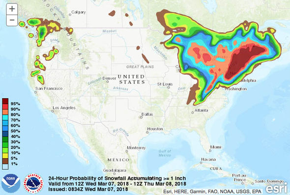
The second nor’easter in the span of a week is heading for the US, threatening more than 50 million residents on the east coast with heavy snow and high winds.
Authorities from Philadelphia to Boston issued urgent weather warnings as the mini-cyclone prepares to unleash its full might on Wednesday morning. Ahead of the anticipated carnage, New Jersey Governor Phil Murphy declared a statewide emergency last night.

Some 2,000 flights have already been canceled on Wednesday alone, as the nor’easter is expected to track devastating wind gusts between 30mph and 50mph.
The Southeastern Pennsylvania Transportation Authority (SEPTA) warned of imminent power cuts and severe traffic delays.
SEPTA Chief Press Officer Andrew Busch said: “In general terms, with a storm like this that’s expected to deliver wet, heavy snow and bring high winds, overhead rail power lines and downed trees in tracks and on roadways are a concern.”

The National Weather Service (NWS) warned: “A surface low pressure and the associated frontal system is quickly transitioning into to a nor’easter and will spread snow to much of the northern Mid-Atlantic and Northeast today through the end of the week.
“Numerous Winter Storm Warnings and Winter Weather Advisories are in effect across portions of the northern Mid-Atlantic and the Northeast. The storm is expected to track offshore the Del-Mar-Va peninsula northward while paralleling the Northeast Coast.”

It is already snowing in parts of Massachusetts and NWS Boston expects the snowy conditions to deteriorate further into the day. Snowfall will continue to track further inland over the Great Lakes over the next few days, as the area of low pressure persists.
Thunderstorms and showers are also expected to have an impact on parts of central and southern Florida later today as the cold front pushes from the south.
Though the weather front will remain closer to the coast this time around, snowfall impacts will still punish the major cities in the region. The nor’easter promises to dump anywhere between four and eight inches of snow in parts of the Northeast.

The New York office of the NWS is looking towards severe power outages, downed trees and between one and two inches of snowfall an hour today.
New York NWS said: “Heaviest precipitation falls from Wednesday morning into early Wednesday evening. Strong easterly winds of 20 to 30 mph with gusts 40 to 50 mph along the coast. Widespread minor to locally moderate coastal flooding expected during high tide Wednesday afternoon. Widespread moderate flooding in the southern bays of Western LI and Jamaica Bay.”
Snowfall between four and six inches will strike Philadelphia later today, prompting authorities to advise against traveling after 7 am ET.
A state of emergency has been issued in several counties.
NWS Boston warned: “While one can critique snowfall amounts, take-away, it’s going to snow and the biggest concern is downed limbs, trees, powerlines with 30-60 mph easterly gusts, strongest along the coast; can’t rule out 2-3″/hr snowfall rates, lowered visibility, hazardous travel.”
Up to three inches of snowfall will impact Boston, and areas about 20 miles inland are expected to get about 10 or more inches of snow.
For the full article, head to express.co.uk
This storm already happened. Look at the weather map it says March 7th to the 8th.
Why was it put up yesterday?