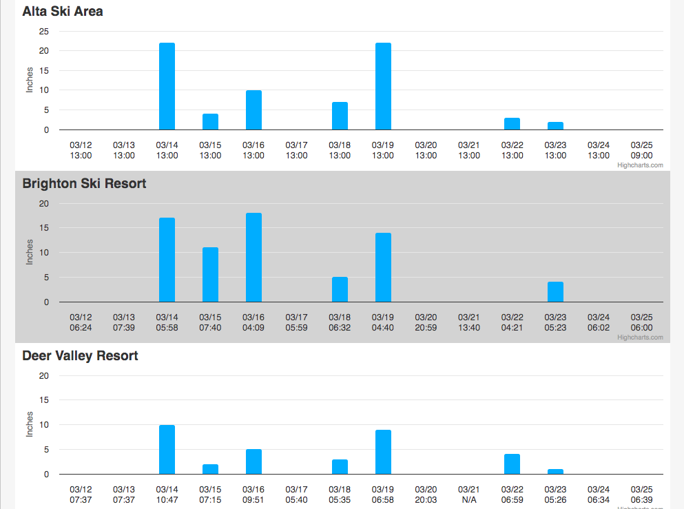
Salt Lake City, Utah, has long been considered one of the best spots to have relatively easy access to lots of good snow while not excluding yourself from civilization. While in recent years, getting from Salt Lake City to the ski resorts has been more challenging, Salt Lake still remains one of the best hubs for skiing in the world as it is located less than an hour’s drive away from four ski resorts Alta, Snowbird, Solitude, and Brighton, which each see more than 500 inches of snowfall on average every season. However, this season, Salt Lake City itself has received very little snow.
According to the National Weather Service (NWS), Salt Lake City’s normal seasonal snowfall is 51.8 inches a year. The city has seen just 18.1 inches of snowfall this year, the fourth-lowest total since records began. Although this may raise concern, the NWS said that snow is still possible through May, so totals could drastically improve by the end of the season. The mountains in Utah are also seeing a good season, with the current snowpack standing at 105 percent over the median peak.
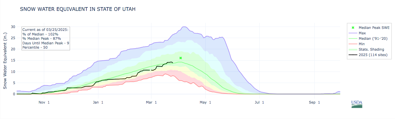
According to the Utah Department of Natural Resources, approximately 95% of Utah’s water comes from snowpack. Reservoir storage depends on snowpack and runoff to sustain it through dry years. Utah’s current reservoir storage remains high (74%) due to 2023’s incredible snowpack and prudent water management. “2022-2023’s record-setting snowpack provided some much-needed relief for Utah’s water supply, and 2023-2024 was abundant too,” the Utah Department of Natural Resources said on its website.
In Salt Lake City’s case, only 1938, 2003, 1891, 1943, and 1934 had slower starts to the snow collection season by this point. The good news is that snowstorms have produced snowfall for the mountains in Utah, which means more for the state’s water supply. Alta is one of those ski resorts and is known for having the best snow in the United States. It currently has a base depth of 141 inches and a season total of 482 inches. The phrase ‘The Greatest Snow on Earth,” originated from a column by Salt Lake Tribune ski writer Tom Korologos in the late 1950s. But it’s not just the sheer quantity that makes Utah snow ‘great.’ The snow’s lower density and lightness create that classic movie image of skiers gliding down the mountain in white clouds of perfect powder.
So, why do Utah’s mountains receive so much snow? According to the National Weather Service, Utah’s storms generally originate in the North Pacific Ocean. When cold Arctic air meets warmer Pacific waters, a Wasatch snowstorm begins. Moisture-heavy clouds cross the Nevada and Utah deserts unimpeded by high mountain ranges, pick up more moisture over the Great Salt Lake, and then hit the 11,000-foot peaks of the Wasatch. That pushes the clouds higher into colder air, the moisture condenses, and the snow begins to fall.
At first, the snow is generally denser and moister; as the rising air gets colder, the moisture dries out, and the snow becomes lighter. Another function of these storms is that more snow falls on the west side of the mountains in Big and Little Cottonwood Canyons than where Park City lies. Surprisingly, Park City totals still generally exceed annual snowfalls at almost all other Rocky Mountain resorts. The scientific term for the phenomenon of storms pushed higher by the mountains is called the orographic rise or lift.
If snow totals are going to improve in Salt Lake City this season, it won’t be this week. Record-breaking temperatures are expected, with highs in the upper 70s in the northern valleys before cooler weather returns over the weekend. But the season is far from over. While Salt Lake City typically sees its last snowfall by mid-April, records show it has snowed as late as June 6.
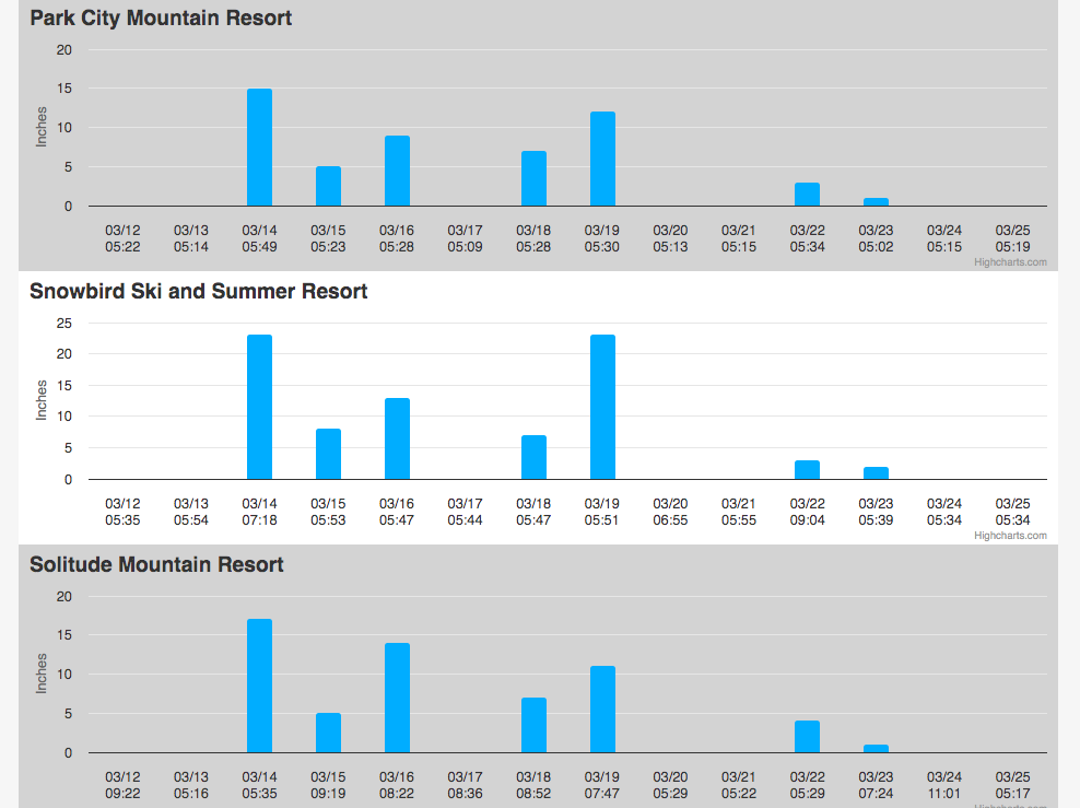
Current Snow Reports from Salt Lake City’s Ski Resorts