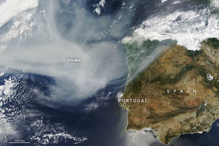
Smoke from wildland fires, which have been burning in the Canadian province of Quebec for weeks, has crossed the Atlantic Ocean and darkened skies in southwestern Europe.
The Moderate Resolution Imaging Spectroradiometer (MODIS) on NASA’s Terra satellite acquired this image in the morning (11:10 Universal Time) on June 26, 2023. At the time, smoke drifted over northern Portugal and Spain. It also reached northward over other European countries beyond the scope of this image.

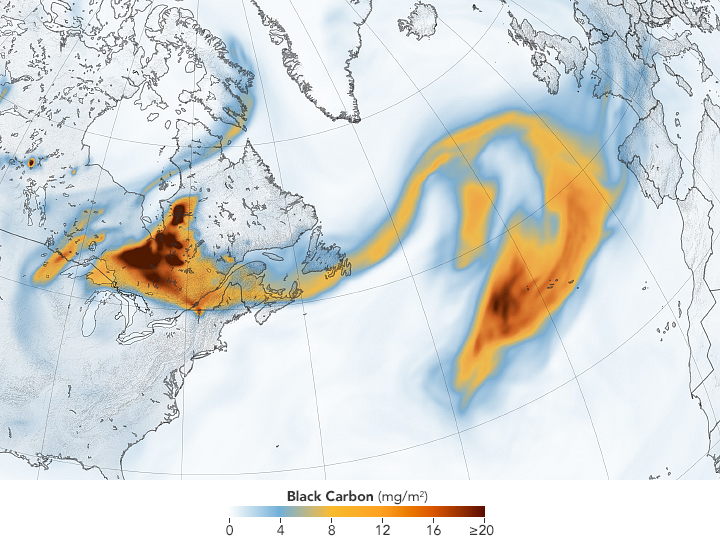
The smoke’s widespread reach is apparent in the map above. It shows a plume of black carbon particles—commonly called soot—spanning eastward from North America and across more than 2,000 miles of the Atlantic Ocean. The black carbon density data come from NASA’s GEOS forward processing (GEOS-FP) model, which assimilates data from satellite, aircraft, and ground-based observing systems. In addition to making use of satellite observations of aerosols and fires, GEOS-FP incorporates meteorological data like air temperature, moisture, and winds to project the plume’s behavior.
Hazy skies in Europe were also observed by a global network of ground sensors called the Aerosols Robotic Network, or AERONET. The network contains more than 500 Sun photometer instruments that measure aerosol optical depth (AOD) around the world. On the morning of June 26, AERONET sensors in northern Spain and France measured AODs greater than 0.5. The AOD in these areas is typically close to 0.1. (For reference, a perfectly clear sky would have an AOD of less than 0.05, while an AOD of 3 would make it difficult to see the Sun.)
Yet air quality in the smoke-covered parts of Europe on June 26 remained mostly fair, compared to unhealthy and hazardous air quality in the smoke-affected parts of Canada and the United States. That’s because most of the smoke that reached Europe was higher in the atmosphere, where it is less likely to affect human health.
Still, the smoke over Europe will likely be noticed by people. According to the UK Met Office, the smoke aerosols could contribute to vivid sunrises and sunsets.
This. post first appeared on NASA Earth Observatory. NASA Earth Observatory images by Lauren Dauphin, using MODIS data from NASA EOSDIS LANCE and GIBS/Worldview and GEOS-5 data from the Global Modeling and Assimilation Office at NASA GSFC. Story by Kathryn Hansen.