A series of winter storms will bring periods of moderate to heavy snowfall to the higher elevations through early next week, with short lulls between systems and potentially impressive totals by Tuesday. Expect fluctuating snow levels, bursts of gusty winds, and generally cool conditions favoring respectable snow quality, especially during the Sunday–Monday system. Below-normal temperatures may persist later in the month, offering continued chances for unsettled weather.
The first round of snow continues Friday as a moderate to heavy wave sweeps across the mountains. Snow levels will hover around 2,000–3,000 feet in the northern mountains and near 5,500 feet across the Sierra. These elevations should see healthy accumulations in favored terrain, potentially pushing up to or exceeding a foot on the highest peaks. Snowfall rates at times may be impressive under stronger bands, but with snowfall-to-liquid ratios generally in the 9–13:1 range, snow quality will be modest to fair. Gusty south-to-southwest winds will be apparent, particularly along ridgelines, which can impact exposed slopes.
A brief lull arrives on Saturday with only isolated showers lingering in the far north. Most areas will see a noticeable break in precipitation, though winds may remain breezy over the ridges. Temperatures stay near or slightly below normal, and any leftover snow showers will be light. This pause in active weather should be relatively short-lived as the next system quickly approaches.
Late Sunday into Monday ushers in a stronger winter storm poised to deliver heavier snowfall across the region. Snow levels will climb a bit early Sunday but generally remain near or just above 4,500–5,000 feet, so most upper mountain terrain should receive substantial accumulations. Forecasts call for a good chance of at least a foot in many spots, with potential 18- to 24-inch totals at higher passes. Snowfall-to-liquid ratios appear more favorable, often exceeding 14:1 by Monday night, which promises lighter, fluffier snow on upper slopes. Winds will ramp up again out of the southwest, especially Sunday afternoon and overnight, contributing to blowing snow in open terrain. By Tuesday, most precipitation winds down, leaving behind colder air and lingering mountain flurries.
Looking further ahead into mid to late March, below-normal temperatures are favored to persist across the West. This broader pattern suggests continued troughing over the region, which can lead to additional opportunities for storms, especially in areas closer to the Pacific Northwest. Confidence in exact timing and strength of any systems is lower, but the overall outlook leans toward cooler and occasionally unsettled conditions through next week.
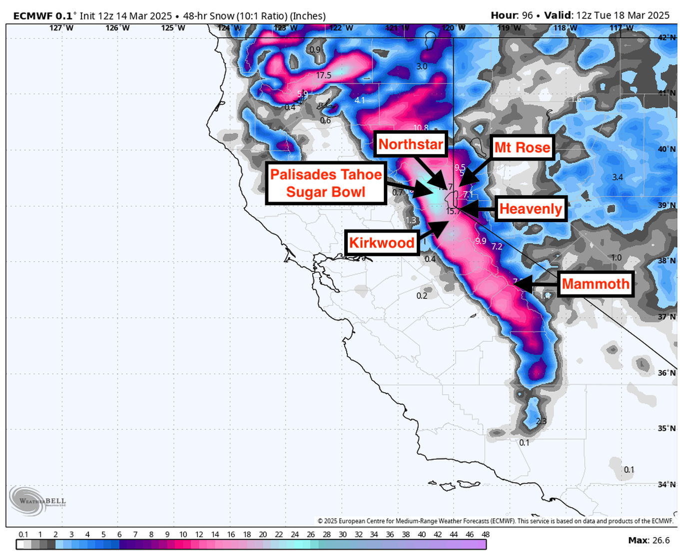
Resort Forecast Totals for Next Storm
- Kirkwood – 14″–24” Sun night (03/16) – Tue night (03/18))
- Palisades Tahoe – 12″–21” Sun night (03/16) – Tue (03/18))
- Sugar Bowl – 12″–20” Sun night (03/16) – Tue (03/18))
- Mammoth – 7″–14” Sun night (03/16) – Tue night (03/18))
- Northstar – 7″–13” Sun night (03/16) – Tue (03/18))
- Heavenly – 6″–11” Sun night (03/16) – Tue (03/18))
- Mt Rose – 5″–10” Sun night (03/16) – Tue (03/18))