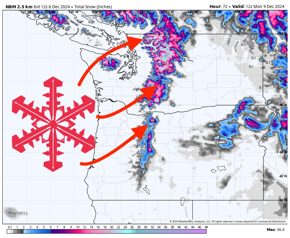
A series of active weather systems will bring periods of precipitation to the Pacific Northwest mountains over the next several days. Initially, expect a strong frontal system moving in late Friday into the weekend, raising snow levels before gradually lowering them as the system exits. After a brief lull in activity early next week, additional storms look to return mid to late next week, bringing more snowfall opportunities at higher elevations.
Through the weekend, a warm front will move in Saturday, pushing snow levels quite high initially—above 7,000-9,000 feet early on—favoring mostly rain in lower mountain elevations. As the main cold front follows Saturday night into Sunday, snow levels will drop closer to 3,000-4,000 feet. This transition will deliver accumulating snowfall to the Cascades of Washington and Oregon, along with more moderate snow in the higher terrain of the northern Oregon Cascades. The heaviest totals should focus on the North Cascades into Sunday, with moderate accumulations extending southward. Winds will turn breezy at times with the frontal passages, especially at upper elevations.
Resorts in Washington’s northern Cascades, such as Mt. Baker and Stevens Pass, are positioned to pick up the highest amounts of snow from the weekend storm. Timberline on the south side of Mt. Hood should also do quite well, with solid accumulations running into Sunday. Farther south, Crystal Mountain and Snoqualmie Pass will see meaningful snow as the colder air arrives late in the weekend, while Mt. Bachelor, being a bit farther inland and south, will pick up lighter totals.
Looking ahead, after a brief break early next week with drier conditions, another round of precipitation is likely to arrive mid to late next week. This next storm series isn’t as clearly defined just yet, but moderate snow accumulations are expected again, favoring areas along the Cascades, with a modest shot for light to moderate snowfall across resorts in Washington and northern Oregon. Stronger ridging early in the week means lower elevations might start out fairly quiet, but by Thursday, cooler air and more moisture will move in, reigniting the chance of fresh powder.
Longer range, models hint at continued unsettled conditions, with periodic systems drifting into the region. This pattern suggests multiple opportunities for mountain snowfall heading toward mid-December. While details on exact timing and intensity remain uncertain, the overarching theme is a return to a more consistently wintry pattern for the Cascades and surrounding mountainous terrain.
Snow Totals:
Friday Night (12/06):
- Snoqualmie Pass: 1″
Saturday (12/07) through Sunday (12/08):
- Mt Baker: 13-22″
- Stevens Pass: 12-20″
- Timberline: 10-17″
- Crystal Mountain: 7-12″
- Snoqualmie Pass (Saturday night through Sunday): 7-11″
- Mt Bachelor: 3-5″
Wednesday Night (12/11): (minor event)
- Mt Baker: 1″
Thursday (12/12) into Friday (12/13) (preliminary):
- Mt Baker: 7-11″
- Stevens Pass: 5-9″
- Snoqualmie Pass: 5-8″
- Timberline: 4-5″
- Crystal Mountain: 3-4″
- Mt Bachelor: 2-3″