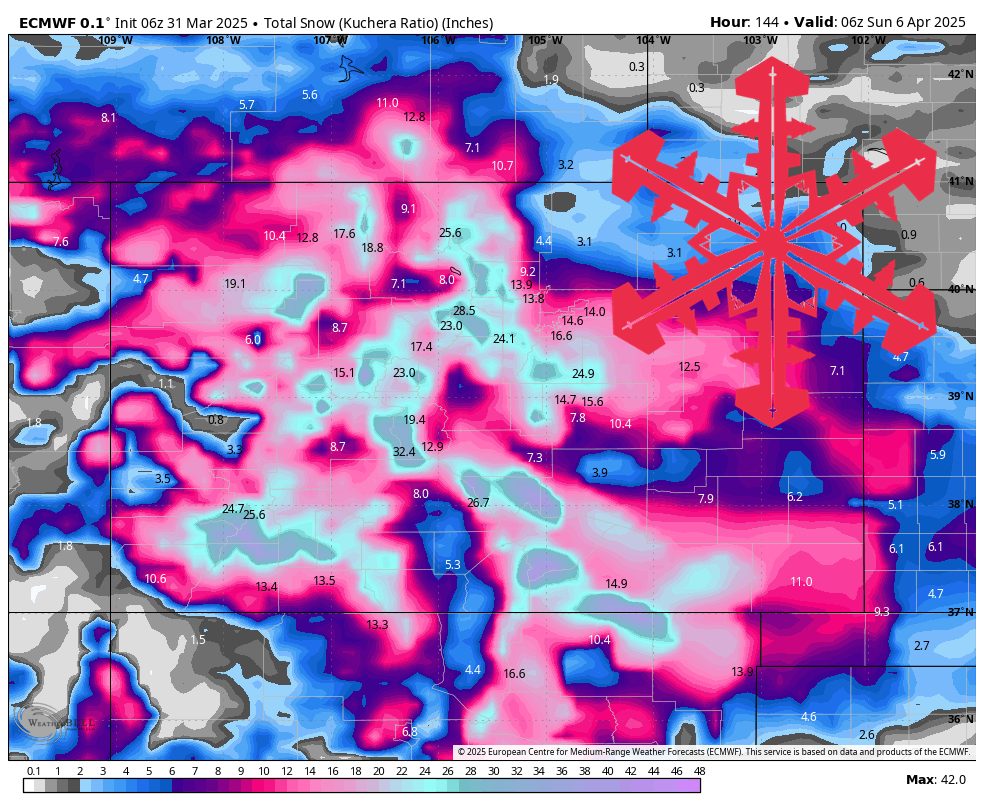
A series of active systems will keep snow flying across the Colorado mountains through the upcoming week, with notable accumulations favoring the northern and central zones early, then shifting to the southern mountains late. Expect mostly below-average temperatures throughout, combined with occasional bursts of gusty winds and relatively high snow-to-liquid ratios that should promote light to moderately fluffy powder.
The first wave will impact the mountains Monday night through Wednesday. Snow will intensify Monday night and continue through Tuesday across the northern and north-central ranges, with areas along and north of Interstate 70 likely to pick up moderate to locally heavy accumulations. During this period, snow levels remain cold enough for all-snow in the high country, and relatively high snow-to-liquid ratios (SLR) with some resorts topping 15:1 or higher by Tuesday night, pointing to decent powder quality. By Wednesday morning, the heaviest snowfall will taper off, though light snow showers may linger in spots.
By midweek, a brief lull moves in on Wednesday, though scattered snow showers still persist. Additional accumulations should be minor, but temperatures remain on the cooler side of average. Winds will also dial back somewhat compared to Tuesday. Keep in mind that localized upslope effects in the eastern slope resorts may continue to wring out lingering flakes through midday Wednesday, though widespread organized snowfall diminishes for most mountain locations.
A secondary disturbance moves in Thursday, bringing modest snow to the Front Range and portions of the central and southern mountains. The eastern slopes near the Denver and Boulder corridor could see light accumulations, with snow quality remaining fairly respectable thanks to continued cool temperatures. Farther south, the San Juans keep an eye on a potential wave late Thursday into Friday, but specifics remain a bit uncertain. SLRs will likely stay in the moderate to higher range, so any new snow that does fall should be decently light.
Friday through the weekend, expect additional rounds of unsettled weather impacting all mountain zones. Higher confidence exists for a more notable accumulation event in the southern mountains—especially by Saturday—though finer details are still evolving. Elsewhere, periodic light snow in the central and northern mountains should keep surfaces refreshed without delivering quite the same totals as earlier in the week. Through Sunday, temperatures remain below normal, helping preserve the snowpack and maintaining generally high-quality conditions on the slopes.
Resort Forecast Totals
- Monarch – 11”–21” total (5”–8” Mon night (03/31) – Wed night (04/02) + 6”–13” Wed night (04/02) – Sat night (04/05))
- Wolf Creek – 11”–21” total (4”–7” Mon night (03/31) – Tue night (04/01) + 7”–14” Wed night (04/02) – Sat night (04/05))
- Loveland/Arapahoe Basin – 11”–20” Mon night (03/31) – Sat night (04/05)
- Telluride – 11”–20” Mon night (03/31) – Sat night (04/05)
- Snowmass – 11”–19” total (9”–14” Mon night (03/31) – Fri (04/04) + 2”–5” Fri (04/04) – Sat night (04/05))
- Winter Park – 11”–18” Mon night (03/31) – Sat night (04/05)
- Crested Butte – 9”–17” total (7”–10” Mon night (03/31) – Wed night (04/02) + 1”–2” Wed night (04/02) – Thu night (04/03) + 1”–5” Fri night (04/04) – Sat night (04/05))
- Vail/Beaver Creek – 9”–16” total (7”–11” Mon night (03/31) – Wed night (04/02) + 2”–5” Thu (04/03) – Sat night (04/05))
- Copper Mountain/Breckenridge – 9”–16” Mon night (03/31) – Sat night (04/05)
- Steamboat – 8”–12” Mon (03/31) – Wed night (04/02)