A dynamic week is on tap for California ski areas, with initially warm conditions giving way to multiple rounds of snowfall and variable snow levels through early next week. Expect gusty winds and bursts of cooler air later in the week, followed by a more significant round of snowfall Sunday into Monday.
Tuesday remains unseasonably warm across the Sierra. Temperatures will hover well above freezing at mid-mountain elevations, limiting any fresh snow chances. Mild conditions will persist into Wednesday, though a slight cooldown arrives midweek. By late Wednesday, light snow may develop across the far northern Sierra with high snow levels around 9,000 feet initially. Higher elevations could see very light accumulations, but lower slopes will likely remain rain or a mix, especially earlier in the day. Gusty winds will begin to ramp up, reaching 40 mph in some exposed areas, which may briefly impact upper lifts.
Thursday through Saturday brings a more pronounced wave of cooler air and steadier snowfall. Winds will continue strengthening on Thursday, potentially gusting near 50 mph along ridgelines. Snow levels should drop to around 6,000 feet on Thursday, bringing light to moderate accumulations at higher elevations. From Thursday into Saturday, new snowfall totals of a few inches are possible along the Sierra crest, though many areas will see relatively modest accumulations overall. Snow quality may vary, with Snow-Liquid Ratios (SLRs) generally in the 7:1 to 12:1 range—spotty lower SLRs could mean denser, heavier snow at times, but still decent turns by Friday and Saturday as temperatures trend cooler.
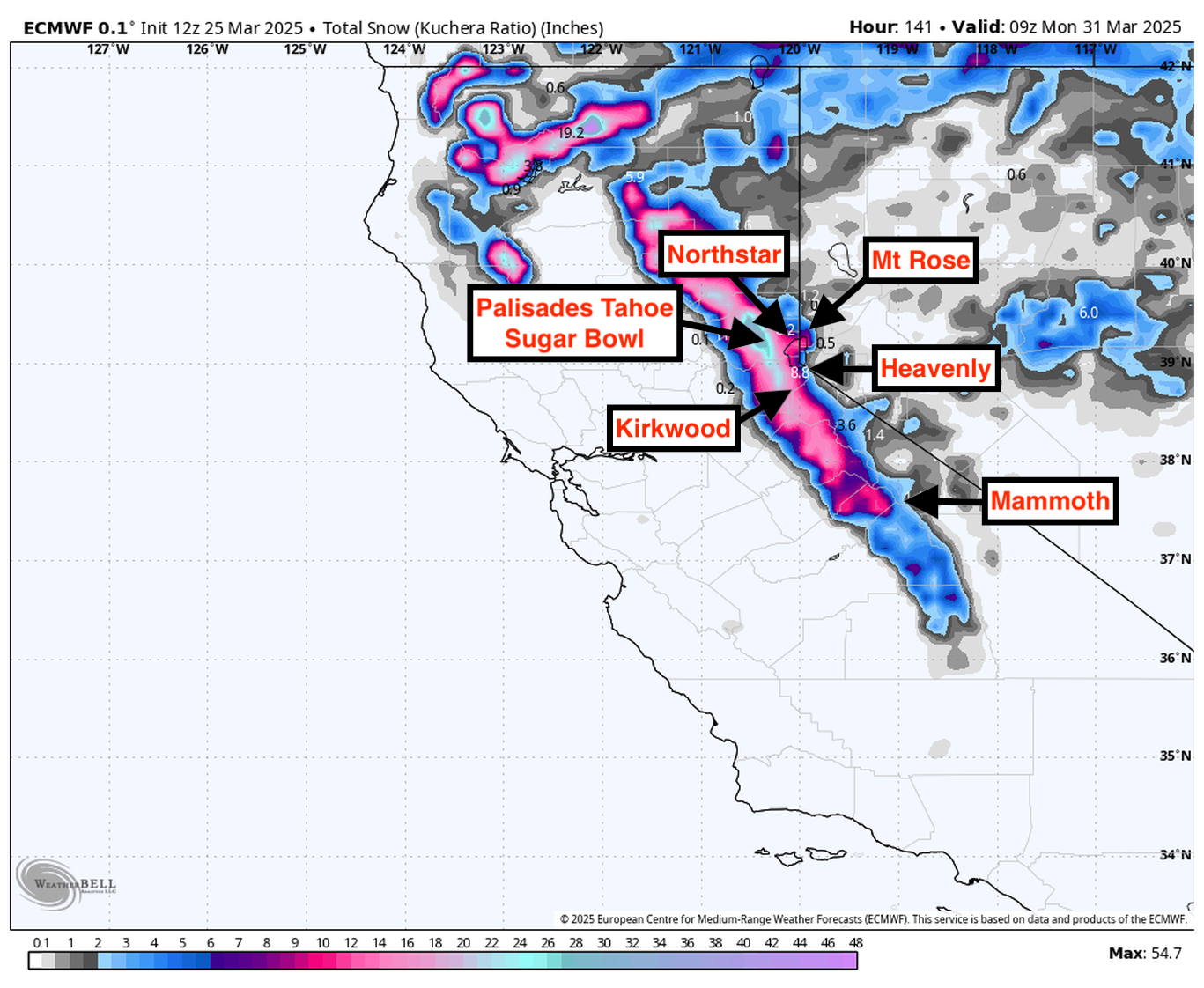
A second round of snow is likely Sunday into Monday, favoring elevations above 5,000 feet. This system carries the potential for a bit more widespread coverage, with around half a foot possible in the northern Sierra. Even Mammoth further south should see at least a few inches from Sunday to Monday morning. SLRs around 8:1 to 10:1 suggest a moderately dense but still skiable snowpack. Looking further out into next week, a continued active pattern could deliver additional storms, particularly for the higher elevations where slightly below normal temperatures may hold on. The broader 6-10 and 8-14 day outlooks favor above normal precipitation in the West, offering additional chances for more snow in the Sierra despite some warmth at lower elevations.
Resort Forecast Totals
- Kirkwood – 5″-14″ total (3″-7″ Thu (03/27) – Sat night (03/29) + 2″-7″ Sun (03/30) – Mon (03/31))
- Palisades Tahoe – 5″-12″ total (3″-6″ Thu (03/27) – Sat night (03/29) + 2″-6″ Sun (03/30) – Mon (03/31))
- Sugar Bowl – 5″-11″ total (3″-6″ Thu (03/27) – Sat night (03/29) + 2″-5″ Sun (03/30) – Mon (03/31))
- Mammoth – 1″-4″ Sun (03/30) – Mon (03/31)