Forecast prepared at midnight MST on Wednesday, November 20, 2024
Forecast Summary
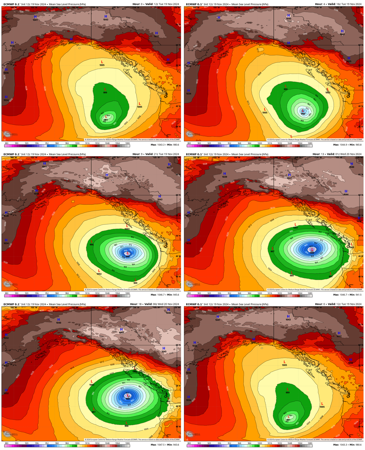
- A low-pressure system off the west coast of the United States has rapidly intensified, reaching the criteria of a ‘bomb cyclone’
- This storm will force the jet stream to dip south around the center of low pressure before blasting the Northwest US with very moist air
- Massive amounts of rain and snow will fall as this moist air runs into the Cascades, with the Northern Rockies forcing out any remaining moisture
- 1-2 feet of snow are expected to fall on the Western and Northern Idaho mountains through Friday
- A second low-pressure system off the west coast is expected to once again produce an atmospheric river this weekend, which should produce more widespread snow in the Rockies

A storm off the coast of Oregon has been rapidly intensifying and has met the criteria for a ‘bomb cyclone.’ A bomb cyclone is one whose atmospheric pressure drops 24 millibars or more in 24 hours or less.
Despite the headlines surrounding the bomb cyclone, the impact of this storm is that the cyclone will generate an atmospheric river that makes landfall between Northern California and British Columbia. As the atmospheric river runs into the high terrain of the Cascades, it will produce huge amounts of rain and snow.

The Northern Rockies sit at a higher elevation than the Cascades and, therefore, will be able to squeeze out more of the remaining moisture by forcing air up and over the terrain. The mountains of Central Idaho, in particular, appear poised to see significant snow totals through Friday.
Forecast Snow Totals through Friday:
- Tamarack (ID): 8-12″
- Schweitzer (ID): 10-18″
- Sun Valley (ID): 10-18″
- Bogus Basin (ID): 2-5″
Weekend Forecast
Another storm forms this weekend just a bit further south than the first. Current indications suggest that this second storm may intensify rapidly enough to qualify as a ‘bomb cyclone’.
The storm track’s being further south should help the rest of the Rockies see widespread snow as another atmospheric river, this time targeting Wyoming, Idaho, Utah, and Colorado.
