This forecast was created at 8 a.m. PST on Sunday, March 30, 2025.
A busy week of stormy conditions will deliver moderate to heavy snowfall across the Sierra, with the heaviest accumulations focused on Monday’s main surge. Overall, snow levels will fluctuate initially before dropping for the strongest part of the storm, and winds will be significant on several days. After tapering Tuesday, a lighter round midweek keeps fresh snow in the forecast. Looking further ahead, extended details are uncertain, but no major additional systems are clearly on tap beyond Friday.
Sunday’s wave begins early in the Sierra with steadily rising snow levels. Through the morning, snow levels will initially hover around 5,200 feet and climb to around 7,000 feet by afternoon, bringing a mix of rain and snow to some mid-elevation locations. Up to a foot of new snow may accumulate in select higher-elevation areas of the Tahoe Basin, with slightly lower totals farther south in Mono County. Snow ratios will start out fairly low in the 7–8:1 range, so snow density will be on the heavier side early on. Gusty ridgetop winds could impact upper-mountain operations, especially by late afternoon.
Monday will be the big hitter, featuring intense snowfall rates and lower snow levels. By midday, colder air pushes snow levels down toward 3,000–4,000 feet, allowing most resorts to see all snow. Storm totals of well over a foot are likely for many high-elevation ski areas, and some locations in the Tahoe region could see over two feet before this system begins to diminish. Snow quality will improve as snow-liquid ratios climb into double digits, peaking around 11–14:1 by late Monday night. Winds will remain strong and potentially gusty over ridgelines, so expect energetic conditions on the mountain.
Lingering snow showers will persist into Tuesday, though not as heavy as Monday’s storm. Another 6–12 inches could stack up along the highest ridges, with moderate snow ratios in the 12–15:1 range leading to fairly light, powdery accumulations. By Tuesday night, precipitation should ease, but a weaker system from Wednesday into early Friday may drop light snow above roughly 4,000–5,000 feet. Amounts look modest for midweek—likely only a few inches in most spots. Beyond Friday, extended guidance remains unclear, but no large storms are confidently indicated at this time.
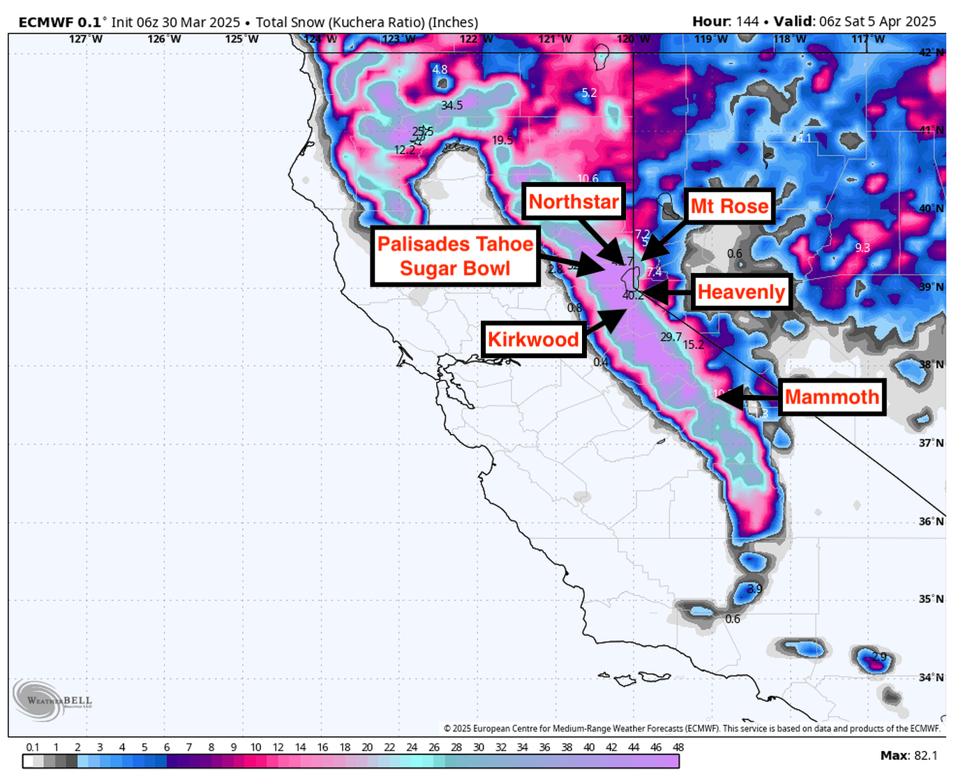
Resort Forecast Totals
- Kirkwood – 28″-41″ Sun (03/30) – Wed night (04/02)
- Palisades Tahoe – 26″-38″ Sun (03/30) – Thu (04/03)
- Sugar Bowl – 24″-35″ Sun (03/30) – Thu (04/03)
- Northstar – 14″-21″ Sun (03/30) – Wed (04/02)
- Mammoth – 13″-20″ Sun (03/30) – Wed night (04/02)
- Mt Rose – 11″-16″ Sun (03/30) – Thu (04/03)
- Heavenly – 10″-15″ Sun (03/30) – Wed (04/02)