Source: maps.weatherbell.com
This forecast was written at 6 p.m. MST on Monday, December 23, 2024
Many people in Idaho, Wyoming, and Montana will have a chance to see a White Christmas this year, but they may need to climb a bit for it. Rain and snow are ending across Western Wyoming as of Monday afternoon, a result of the latest “storm” to impact the region. Conventional wisdom would assume that any mountain passes are seeing exclusively snow, but that hasn’t been the case. Rain has been mixing in with snow even over Teton Pass, the high point of a road connecting Jackson Hole to Idaho, with an elevation of almost 8,500 feet! As anomalous as this is, it’s just the beginning of a wet, but also very abnormally warm, pattern that will take us into the new year.
White Christmas?
The second half of Monday and the first half of Tuesday will serve as a dry period between storms, but a much anticipated Christmas Eve storm arrives in Idaho Tuesday afternoon. We know that precipitation will be widespread ahead of the cold front, which arrives several hours after precip begins, but the difficulty is in determining whether that precip will all as snow, rain, or a mixture of the two.
Source: maps.weatherbell.com
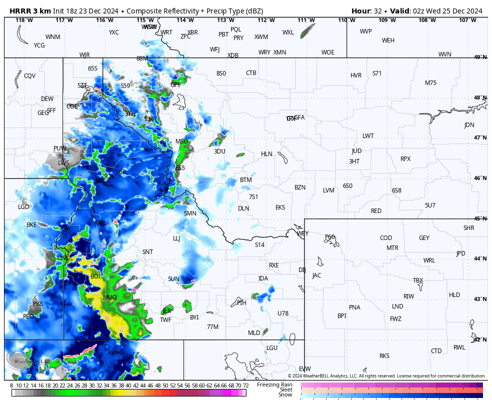
Determining snow levels can be tricky at the best of times, especially in complex terrain like we find in the Northern Rockies. Above is an example of a high-resolution model’s prediction for what the radar will show at 7 p.m. MST on Tuesday and what type of precipitation will fall. The blue is snow, with darker blue representing heavier snowfall. The green/yellow is rain, with yellow representing heavier rainfall. The pink is freezing rain, which doesn’t happen often in this part of the world but could be observed in spots on Christmas Eve. It’s also worth noting that this model is biased towards snow rather than rain and is likely showing snow in some areas that will see rain.
Source: maps.weatherbell.com
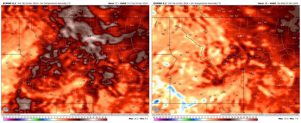
Temperatures will be much warmer than normal on Tuesday, with temperature anomalies ranging from just a few degrees above normal to 25 degrees above normal in parts of Western Montana. A cold front moves in on Tuesday afternoon and evening, which usually results in widespread below-normal temperatures. However, the airmass that arrives behind the cold front isn’t particularly cold either, and it will only drop temperatures down to about 0-15 degrees above normal.
With temperatures like that, it’s no surprise that rain will fall at higher elevations than we would usually see this time of year. With the main wave of precipitation that arrives ahead of the cold front, snow levels are between 6,000-7,000 feet. After the front arrives, snow levels drop down to 4,500-5,500 feet. However, there won’t be much precipitation left after the front arrives, so most snow will fall when snow levels are higher.
Source: maps.weatherbell.com
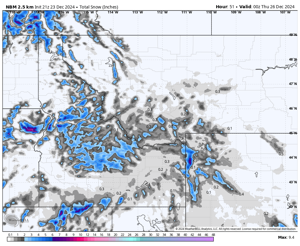
Above is a rough estimate of snow totals through Christmas morning. As you can see, the valleys will struggle to see any snow at all, while the mountains will see a few inches. The Tetons should receive the highest snow totals, in large part because they are the tallest mountains around.
Beyond Christmas
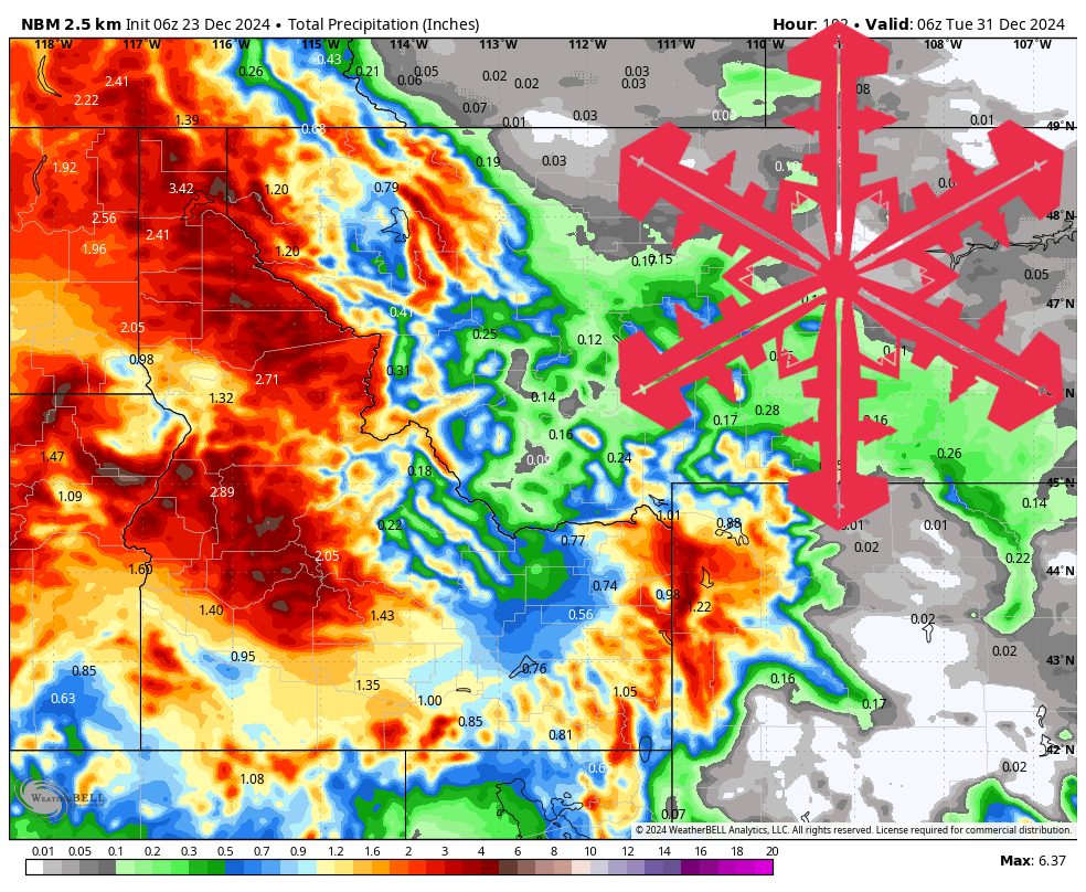
It’s good news for the resorts going forward, as the pattern remains very active through the end of the month. The next storm begins the very next day after Christmas and will have snow levels around 4,000-5,000 feet throughout the storm. There is then a decent chance for snow every day through the 30th, with snow levels varying between 4,000 feet at the lowest and 7,000 feet at the highest. If you’re looking for the best powder, head to Wyoming, where Grand Targhee and Jackson Hole Mountain Resort will stay above the rain/snow line all week and end up with impressive snow totals as a result.
Snowfall totals between now and Jan 1st:
- Tamarack (ID): 24-36″
- Schweitzer (ID): 18-30″
- Sun Valley (ID): 22-32″
- Big Sky (MT): 12-24″
- Jackson Hole (WY): 30-40″
- Grand Targhee (WY): 36-50″
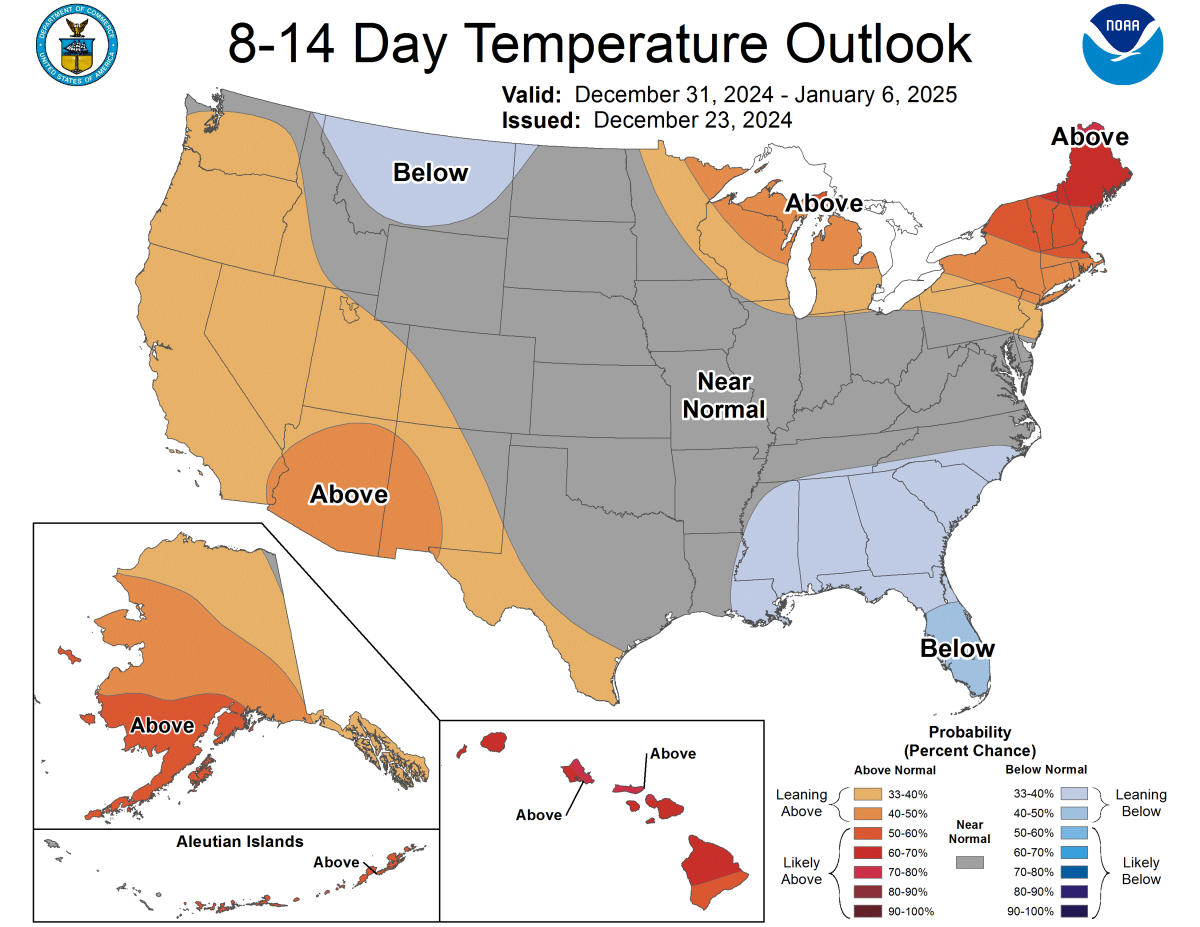
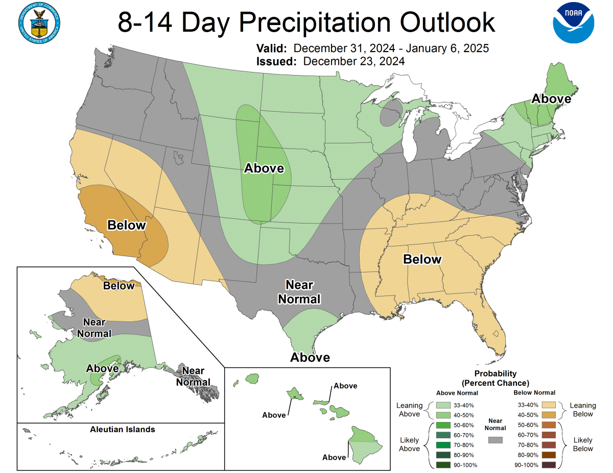
The first week of January looks a lot different, as colder air moves in and snow falls mainly on the lee side of the Rockies:
Source: https://www.cpc.ncep.noaa.gov/products/predictions/814day/
