A series of winter storms will bring rounds of mountain snowfall across the Northern Rockies through this weekend, followed by a short-lived warmup early next week and another potentially wet system late Wednesday. Expect moderate accumulations and generally fair to good snow quality where colder air lingers. Winds will be quite strong at times, creating both exciting storm-riding conditions and occasional challenges on exposed ridgelines. The latter half of next week could reignite fresh snowfall as another small system moves in.
The first disturbance arrives Thursday into Thursday night, ushering in modest snowfall at higher elevations. Snow levels will range from around 2,500 feet in the colder western zones to near 4,000 feet in some eastern sections. Intermittent snow showers will continue into Thursday night, with many mid-mountain areas seeing accumulations of a few inches. SLRs across much of the region will hover in the 10:1 to 15:1 range, translating into fairly light to moderate density snow. Gusty west and northwest winds (topping 25-40 mph) will accompany these showers, potentially impacting lift operations at times but also encouraging quick refreshes on wind-loaded slopes.
The more impactful round develops Friday into Saturday, delivering deeper snow to a broader swath of the northern Rockies. In many locales, this system will begin with snow levels around 4,000 feet or higher on Friday, then crash down near valley floors by Saturday as cooler air filters in. Look for some heavier bursts of mountain snow Friday night into early Saturday, with rates briefly reaching around an inch per hour in favored upslope areas. SLRs will trend in the 8:1 to 12:1 range under the heavier snowfall, then climb back toward 14:1 or so in pockets of colder, post-frontal air. Strong, gusty winds from the northwest will persist into Saturday, enhancing wind-loading on leeward slopes and maintaining plenty of soft turns for those seeking fresh powder.
By Sunday, scattered snow showers linger in the northernmost mountains while warmer air begins building from the southwest. Snow levels will rebound, occasionally jumping from near 3,500 feet to around 6,000 feet by Sunday evening in some areas. Northern Idaho and northwest Montana could still pick up additional light to moderate snow late Sunday into Monday, whereas areas farther south see smaller amounts or even a quick switch to mixed precipitation at lower elevations. Moving into Monday and Tuesday, a strengthening ridge will promote a notable warmup, with mountain temperatures rising and snowmelt accelerating at lower elevations.
Despite the mild spell, late Wednesday into Thursday looks like it could bring a return to unsettled weather, as a new system pushes in with initially high snow levels (7,000-9,000 feet) before potentially dropping lower on Thursday, hinting at fresh mountain accumulations late in the period. Longer-range guidance suggests that the northern tier, including the Northern Rockies, could stay somewhat active in the 8-14 day timeframe, although above-normal temperatures could limit snow quality at times.
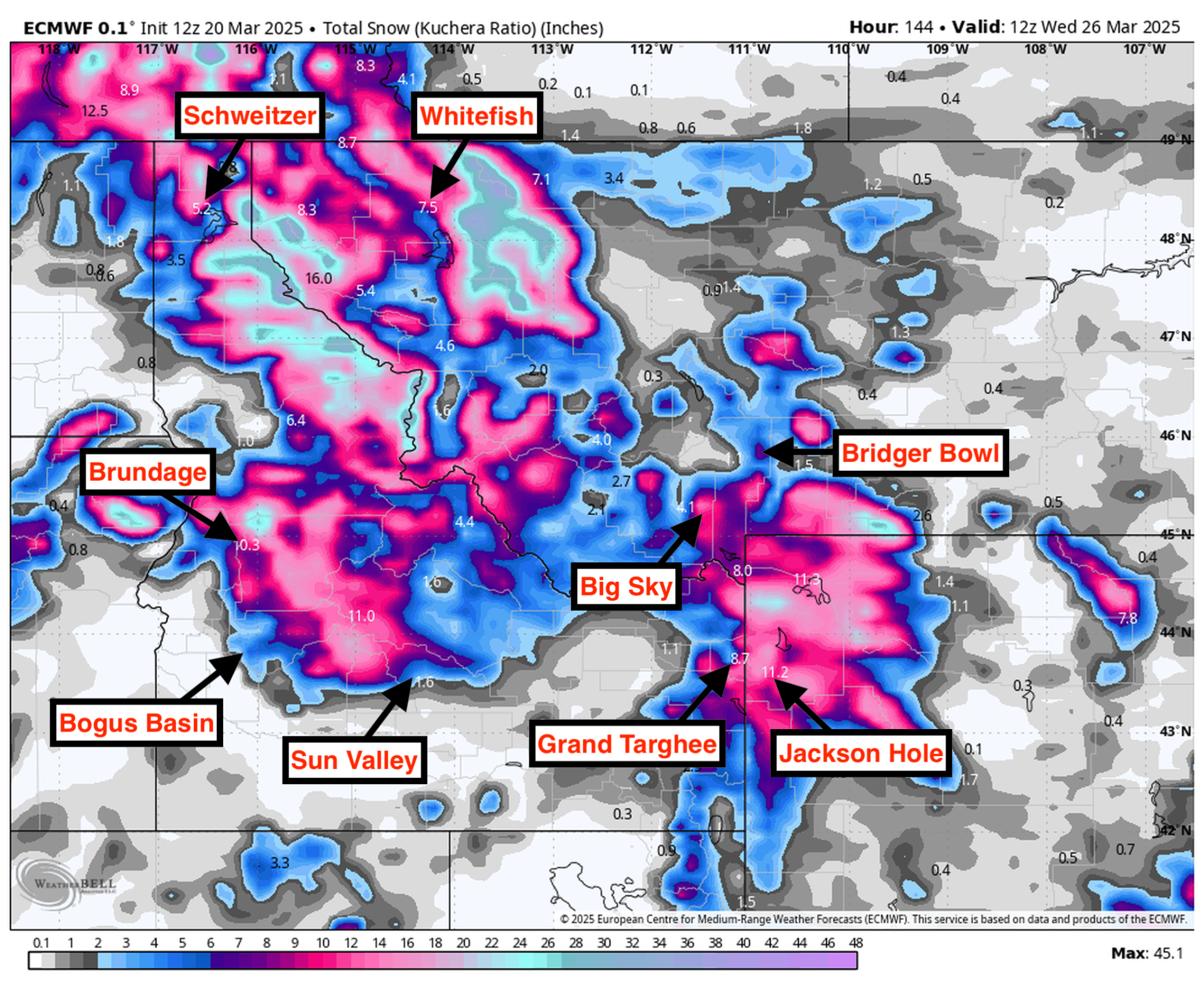
Resort Forecast Totals
- Schweitzer – 9″-15″ total (8″-12″ Thu (03/20) – Sat night (03/22) + 1″-3″ Sun (03/23) – Mon (03/24))
- Brundage – 7″-11″ Thu (03/20) – Sat night (03/22)
- Grand Targhee – 6″-10″ Thu (03/20) – Sat night (03/22)
- Whitefish Mountain – 6″-9″ Thu night (03/20) – Sat night (03/22)
- Jackson Hole – 5″-8″ Thu (03/20) – Sat night (03/22)
- Big Sky – 4″-7″ total (1″-2″ Thu (03/20) – Fri (03/21) + 3″-5″ Fri night (03/21) – Sun (03/23))
- Bogus Basin – 4″-7″ Thu night (03/20) – Sat night (03/22)
- Bridger Bowl – 2″-4″ total (1″-2″ Thu (03/20) – Thu night (03/20) + 1″-2″ Fri night (03/21) – Sat night (03/22))
- Sun Valley – 1″-3″ Fri night (03/21) – Sat night (03/22)