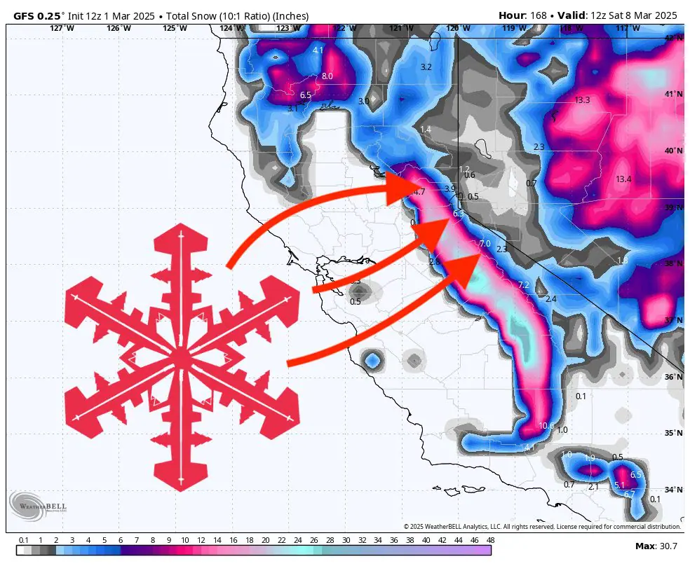
SUMMARY: A series of moderate storms will usher in a welcomed return of winter weather this week, bringing multiple rounds of snowfall and much cooler temperatures to the Sierra. Two main waves will impact ski areas across California, the first moving through from late Saturday night into Monday, and the second arriving midweek from late Tuesday through Thursday. Snow levels will begin relatively high, around 5,000–6,500 feet, but rapidly drop with each storm, eventually lowering to near 4000 feet by later Sunday and again midweek. Snow quality is generally looking good, with SLR values mostly ranging from 11-15:1, promising moderately light and fluffy snow. Winds will be significant at times, particularly during frontal passages, impacting exposed ridgelines and lifts. Looking further ahead, the pattern remains active with colder temperatures and additional storm chances extending into mid-March.
Saturday Night–Monday Storm: After a mild start Saturday, conditions deteriorate overnight into Sunday as the first significant wave moves in. Initially, snow levels will hover around 5,000–6,500 feet, quickly dropping closer to 3,500–4,500 feet Sunday afternoon. Moderate snowfall is expected primarily Sunday afternoon and evening, with totals generally ranging from 4 to 10 inches above 6000 feet. Snow quality will start out fair (SLRs ~10-12:1) but improve significantly by Sunday evening into Monday (SLRs ~13-15:1), resulting in softer, lighter powder. Winds will gust from the southwest and west around 25-35 mph, especially along ridges, possibly affecting lift operations briefly at higher elevations. Areas such as Kirkwood and Mammoth will benefit most, with up to 8 inches possible by early Monday. Additional light accumulations persist through Monday morning before conditions ease into Tuesday.
Midweek Storm (Tuesday Night–Thursday): After a short break late Monday through Tuesday, another, colder system arrives Tuesday night into Wednesday, lasting through Thursday. This wave appears colder and slightly stronger, particularly favoring the southern Sierra near Mammoth and Kirkwood. Snow levels start near 5,500 feet but again quickly drop to around 4,000–5,000 feet by Wednesday night into Thursday. Snowfall totals could reach another 3–7 inches above 6000 feet, with peak elevations likely exceeding half a foot. Snow quality will remain consistently good, especially Wednesday night into Thursday, with SLRs generally ranging from 13-15:1, ensuring continued soft and fluffy snow conditions. Winds may again gust 25-35 mph out of the southwest, possibly higher near ridge crests, impacting exposed lifts and terrain features.
Extended Outlook: Following these storms, brief ridging on Friday and Saturday should yield quieter weather and slightly milder temperatures. However, long-range outlooks indicate another active weather pattern setting up for the second week of March, promising continued snowfall chances, colder-than-average conditions, and potential powder days through mid-March.
Resort Forecast Totals
- Kirkwood – 7″-14” total (5″-8” Sat night (03/01) – Mon (03/03) + 2″-6” Tue night (03/04) – Thu (03/06))
- Mammoth – 5″-12” total (2″-5” Sun (03/02) – Mon (03/03) + 3″-7” Tue night (03/04) – Thu night (03/06))
- Sugar Bowl – 4″-9” total (3″-6” Sat night (03/01) – Mon (03/03) + 1″-3” Tue night (03/04) – Wed night (03/05))
- Palisades Tahoe – 4″-8” total (3″-5” Sat night (03/01) – Mon (03/03) + 1″-3” Tue night (03/04) – Wed night (03/05))
- Heavenly – 2″-6” total (1″-3” Sun (03/02) – Mon (03/03) + 1″-3” Wed (03/05) – Thu (03/06))