Forecast completed 6:00 a.m. on December 24, 2024
Heads up – an updated forecast went up 7am 12/26
Summary
After a terrible start to the 2024-25 winter, Utah’s snowpack is only about half what we expect for this time of year.
The short-term forecast looks as good as it has all year. A preceding storm will impact Utah on Christmas, with follow-up systems arriving Thursday, Friday, and Saturday. Christmas thru New Year’s Day will feature improving riding conditions with soft new snow and quickly improving coverage. Weeklong snow totals in the Cottonwoods may exceed 2-3 feet.
The long-range forecast is much more promising than it has been. A generally snowy weather pattern is expected to last into the beginning of January.
Snowpack Checkup
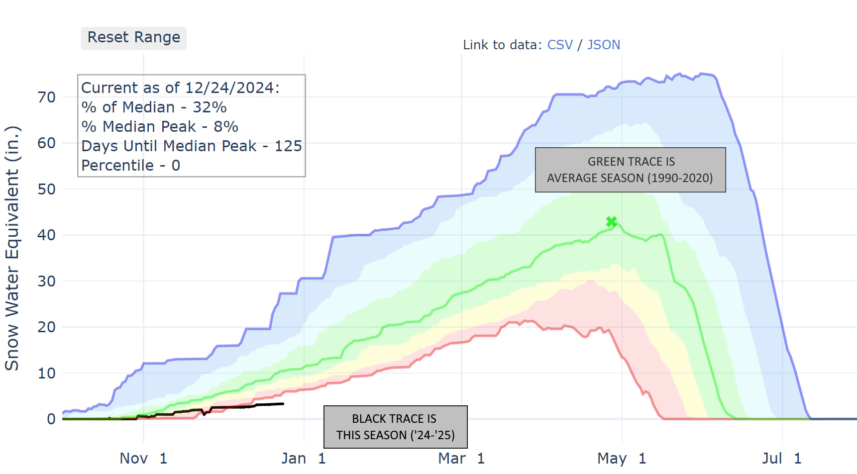
I probably don’t need hard data to convince you of this winter’s abysmal start, but I have some anyway. This map is an excellent resource for checking in on the snowpack, as it gives you access to SNOTEL data from sites across Utah’s high terrain.
One site sits at 9,277′ at Snowbird and has been dutifully recording snowpack data since 1990. Data from this site is plotted below. As you can see, this season is off to the slowest start since the site was put up. This site reports only 32% of the median Dec. 24th snowpack.
Other sites of interest are running dangerously low, too. Brighton’s SNOTEL (at 8,766′) reports 47% of the median snowpack for the date. Thaynes Canyon SNOTEL, representative of Park City & Deer Valley, is also posting its slowest start to winter since observations began in 1989.
Christmas Pow Prospects
We finally have a few decent storms in the forecast.
The first arrives late Christmas Eve. Mountain snow and valley rain showers begin around midnight, with high snow levels falling to nearly 5,000 by Christmas morning. This won’t be a huge snow producer, but all Utah resorts will pick up some new snow, and it won’t be long before the next wave of snowfall moves in.
The best skiing/riding conditions will be found on Christmas morning. Snow tapers off by midmorning Wednesday, by which time you should expect the following:
- Alta, Snowbird, Brighton, Solitude: 5-9″
- Park City & Deer Valley: 4-7″
- Snowbasin, Powder Mountain: 3-5″
- Sundance: 5-8″
- Eagle Point: 4-7″
- Brian Head: 5-7″
- Beaver Mtn: 1-3″
Long Range Outlook
As mentioned, active conditions will continue between Christmas and New Year. Here’s a quick & dirty look at the next couple of storms:
Thursday
Another quick-hitting wave of snow moves across Utah midday Thursday, mostly between 10 a.m. and 3 p.m., though a few snow showers may linger into the evening. Snow levels should be close-ish to valley floors. This won’t be a huge snow producer, but another day of improved skiing is likely. Here’s what you should expect:
- Alta, Snowbird, Brighton, Solitude: 2-4″
- Park City & Deer Valley: 2-3″
- Snowbasin, Powder Mountain: 2-4″
- Sundance: 1-3″
- Eagle Point: 1-2″
- Brian Head: Up to 1″
- Beaver Mtn: 1-3″
Friday
Snow resumes Friday morning continues all day and ends Friday night. Winds look a little stronger on Friday, so don’t be shocked to see gusts to 45 or 50 MPH in the along ridgelines.
Another 5-10″ is likely for the Northern & Central Utah ski areas.
With new snow starting to pile up and strong winds throughout the day, I expect the danger of avalanches to rise by Friday. Follow the avalanche forecast if you intend to venture into the backcountry.
Saturday – Monday
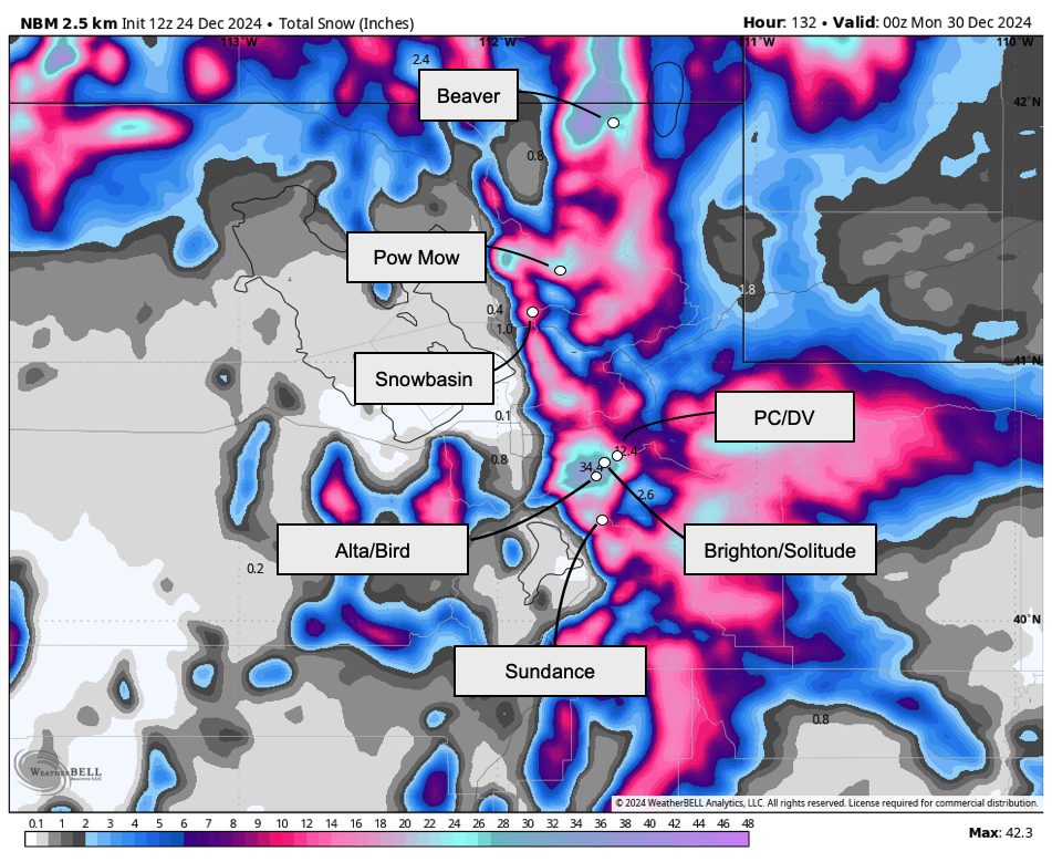
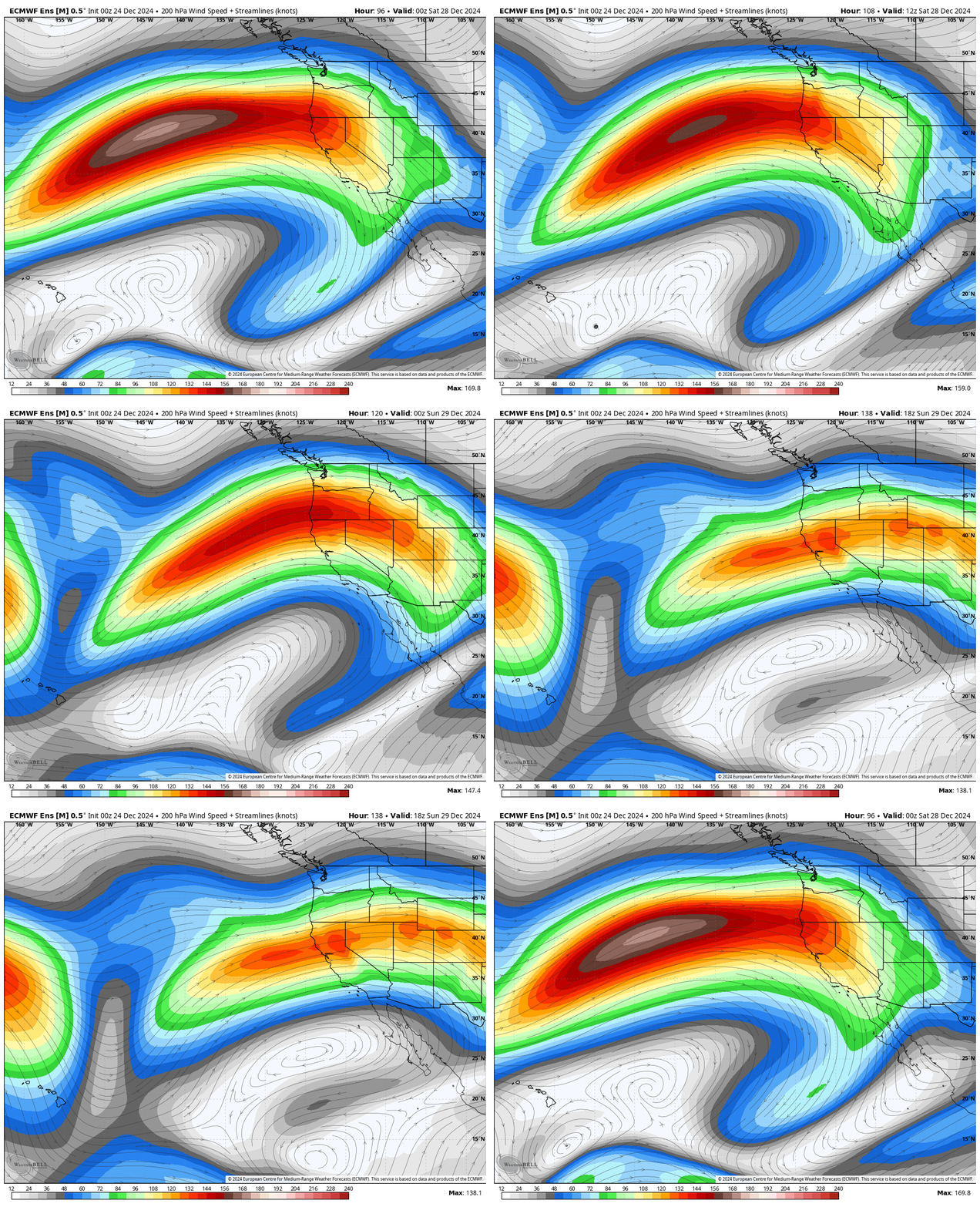
A bunch of fast westerly flow will blast the Western US Saturday through Monday, which will likely bring another wave or two of accumulating snowfall to the Wasatch.
The first chance for snow is Saturday-Saturday night, and it looks very promising. Some model forecasts suggest another 8-16″ for the Wasatch, but I’m still worried it’ll miss to the north. We’ll have to stay tuned but plan to ski Saturday if you can.
A cold front will eventually move across the region on Monday. I shouldn’t speculate much about how much snow will fall, but it’s another chance for a burst of heavy snow.

