Forecast By SnowBrains Chief Meteorologist – Eric McNamee
8:35 PM MST, 12/5/2021
Forecast Summary:
FEET of snow is expected across the western US over the next week as a major pattern change occurs.
The extremely dry November over the west looks to hopefully change going into December as a long-wave trough develops.
Different regions of the west will see rounds of snow at different times.
Short-Term Forecast:
Monday-Wednesday:
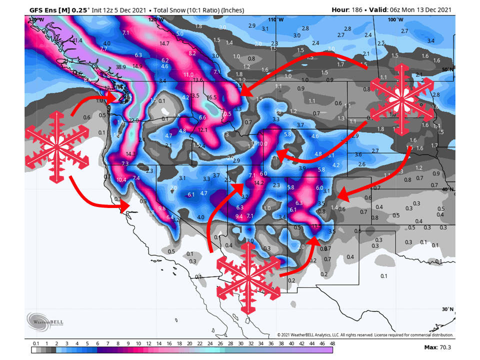
This pattern will start by dropping up to 6″ of snow for portions of the Cascades and 6-10″ for the Northern Rockies through Tuesday as a shortwave trough moves through.
This same shortwave will traverse across the western US, bringing 6-10″ of snow to portions of Colorado.
Around 2-6″ of snow is also expected along the High Sierra of California and the Wasatch Mountains in Utah.
The next trough will start to dig into the PNW Tuesday night, bringing the next round of snow.
This trough looks MUCH colder and potent and will likely bring more widespread heavy snow.
Starting with the PNW, where an additional 8-16″ of snow will fall through Wednesday.
8-12″ is possible in the Northern Rockies from this same shortwave through Wednesday as well.
Long-Term Forecast:
Thursday-Sunday:
Getting into the long-term, the same shortwave will continue to dig and bring HEAVY snow to Utah’s Wasatch, mountains of Colorado, and parts of Wyoming through Friday.
The Sierra will also get in on the action from this shortwave, seeing a healthy amount of snow.
Still too far out to say particular amounts, but these areas will see the bulk of their snowfall during the long-term this week.
Another shortwave trough will bring additional chances of snow to the PNW and Northern Rockies this weekend.
Areas that will likely do the best are the Pacific Northwest, Northern Rockies, Utah, and Colorado.
Extended Forecast:
Sunday and Beyond:
Global ensembles indicate an active pattern will persist in the extended period.
California:
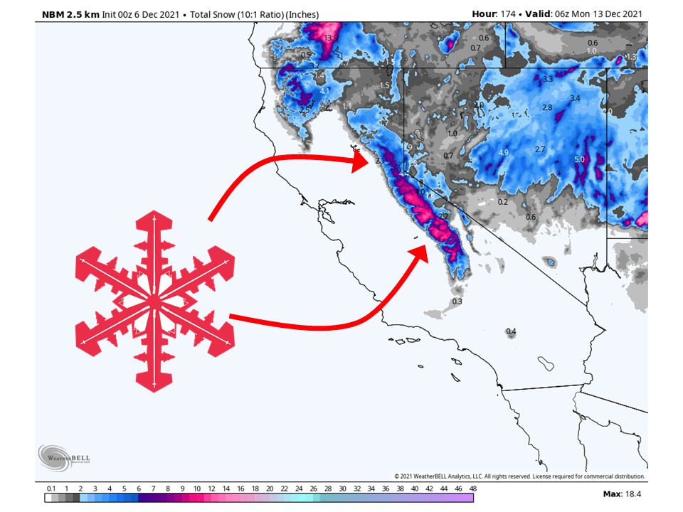
2-6″ of snow is expected across the high Sierra through Wednesday as the initial trough digs down the west coast.
Another trough will move through the state Wednesday, possibly bringing an additional 8-12″ of snow for the Sierra through Friday.
Resorts likely to get the most snow are Boreal, Mammoth, Kirkwood, Sugar Bowl, Palisades Tahoe, Northstar, Homewood, and Heavenly.
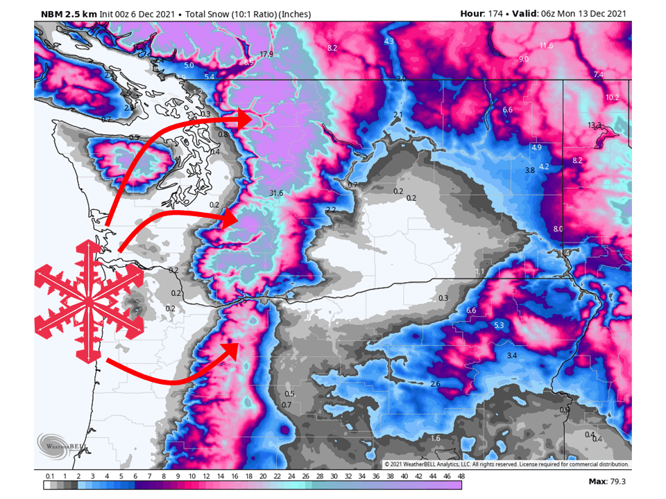
Pacific Northwest:
The Pacific Northwest looks to see 12-24″ of snow through Wednesday as the first two initial troughs move through.
An additional 2-4 FEET of snow is possible through the weekend as more troughs move through the region.
Resorts that look to see the most snow are Mt. Bachelor, Timberline Lodge, Crystal Mountain, Stevens Pass, Alpental, and Mt Baker.
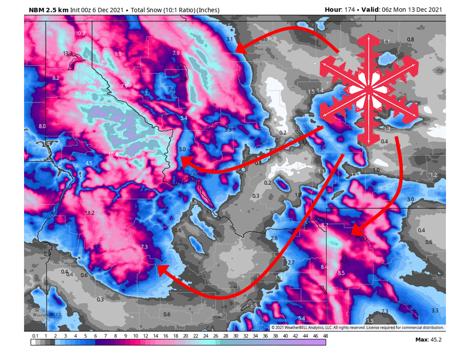
Northern Rockies:
The Rockies look to see 12-24″ of snow through Wednesday as the first two initial troughs move through.
An additional 1-2 FEET of snow is possible through the weekend as more troughs move through the region.
Resorts that look to see the most snow are Jackson Hole, Targhee, Big Sky, Whitefish, Bridger Bowl, and Schweitzer.
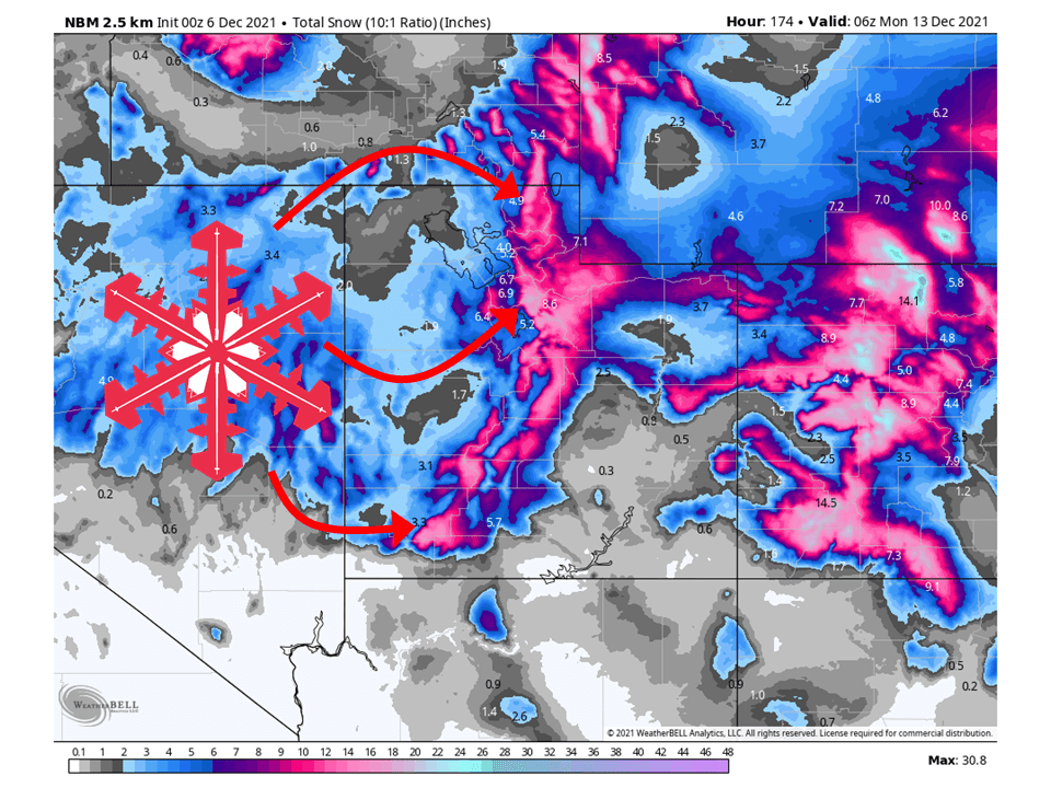
Utah:
Like California, Utah will see 2-6″ of snow through Wednesday from the initial shortwave trough.
The second shortwave moving through the state Thursday/Friday will be much more potent and will possibly bring an additional 8-12″ of snow to most mountains.
Resorts that look favored are Alta, Snowbird, Brighton, Solitude, Park City, Canyons, Deer Valley, Snowbasin, Powder Mountain, Beaver Mountain, and Brian Head.
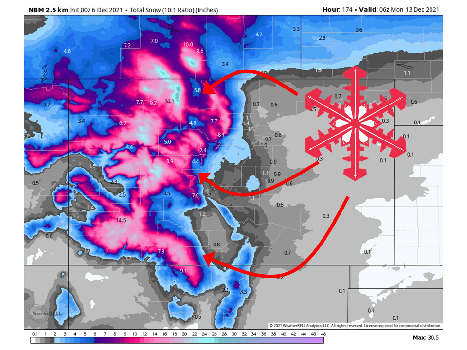
Colorado:
6-10″ of snow is expected through Wednesday in the mountains as the first trough moves through the state.
The second shortwave trough will bring an additional 8-14″ of snow, possibly to parts through the weekend.
Resorts that will see the most snow are Aspen, Steamboat, Vail, Wolf Creek, Telluride, Monarch, Keystone, Crested Butte, and Winter Park.
Extended:
Global ensembles indicate an active pattern will persist in the extended period.