Forecast prepared the evening of Tuesday, February 27
Summary
The Sierra Nevada will see two storms in the next week or so. The first of which will be the biggest snow producer so far this season.
Snow will fall Thursday night-Sunday morning and again at times Tuesday-Friday of next week.
Snow totals from this week’s system will exceed 60″ in favored areas.
Winds will crank in the high terrain on Friday & Saturday, making mountain operations difficult. Any attempts at navigation through high mountain highways will be rough. The author suspects waiting to ski/ride until the storm ends or for the second storm may be smart.
Short Term
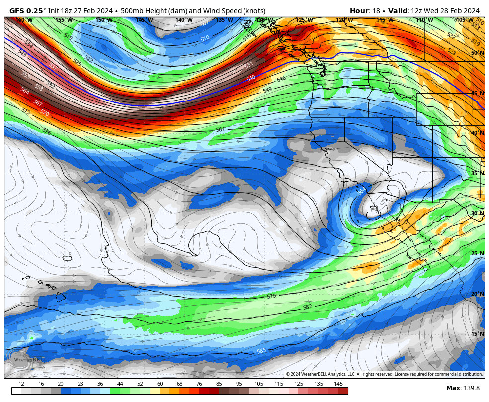
An impressive upper-level trough will bring a prolonged period of moisture-laden onshore flow as it drops into the area:
https://pagead2.googlesyndication.com/pagead/js/adsbygoogle.js?client=ca-pub-8046357598108762
(adsbygoogle = window.adsbygoogle || []).push({});
Mountain snow will begin midday Thursday for most areas and by Friday in Mammoth. Snow continues until Sunday a.m., with extreme snowfall rates at times.
What’s notable about this storm is the prevalence of a ton of cold air. Snow levels will fall from ~6,000′ as the storm begins to a very low ~2,500′ by Saturday. This will allow for fluffier snow and higher snow-to-liquid ratios than the region is accustomed to.
The upper elevations along and just west of the Sierra Crest are forecast to receive 5-9″ of liquid equivalent from this storm. I think snow-to-liquid ratios will get as high as 15:1 at times, so total snowfall will be extremely impressive when things wrap on Sunday morning.
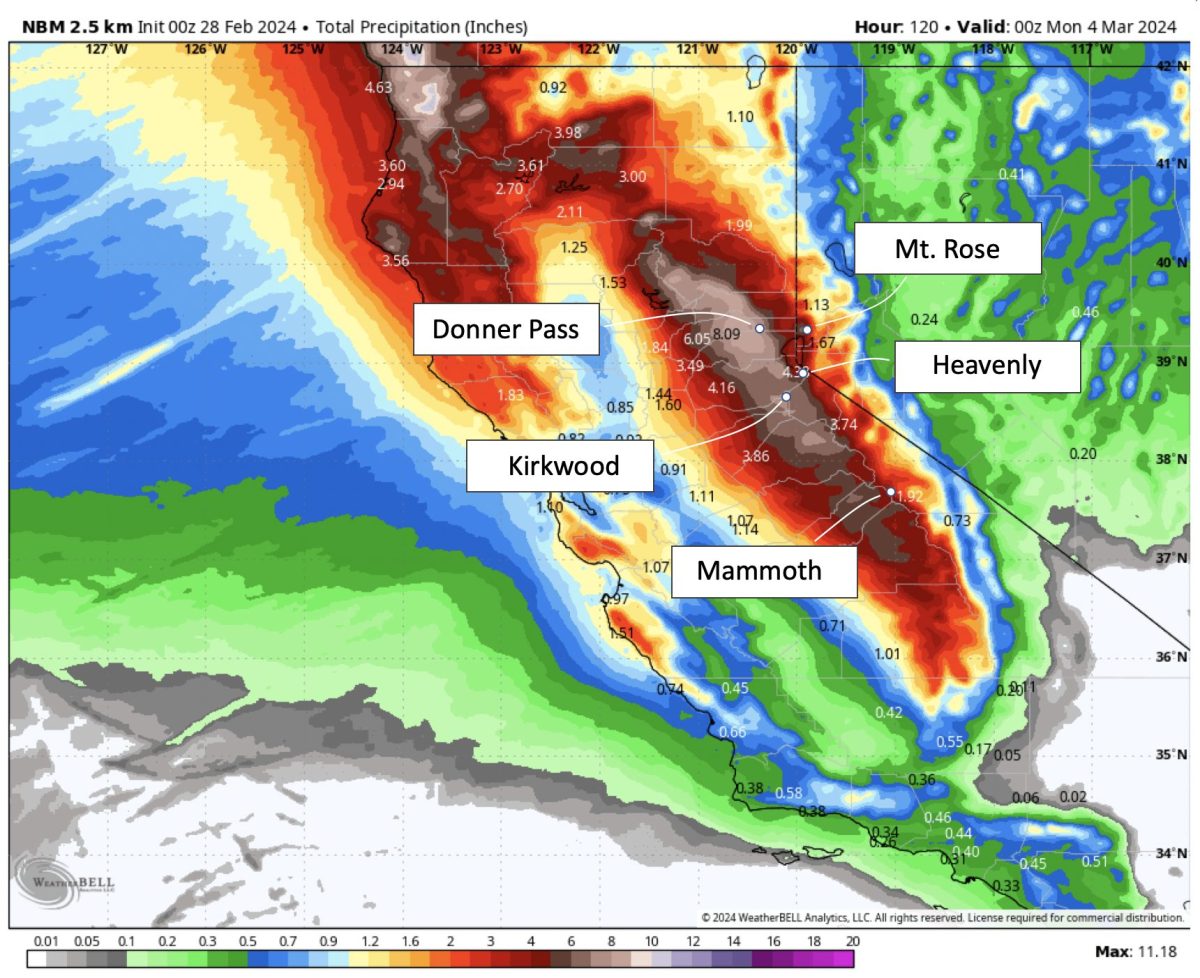
Thursday-Sunday Snow Totals:
- Donner Pass – Boreal, Sugar Bowl, Soda Springs: 70-120″
- Palisades: 60-90″
- Heavenly: 40-65″
- Mt. Rose: 50-80″
- Kirkwood: 60-90″
- Mammoth: 30-50″
If long-duration road closures aren’t your thing, don’t worry. There’s another chance to score freshies next week.
Next Week
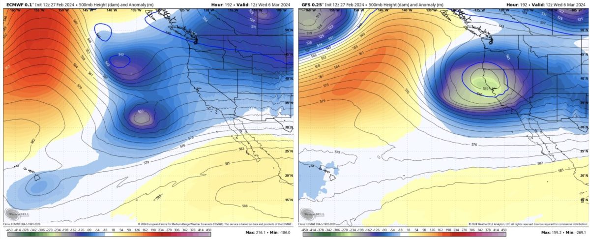
Weather models disagree on how the upper-level pattern will evolve behind the first storm. This isn’t a surprise; we’re still about a week out. Check out the differences in two of the most popular models’ depictions below for the pattern on Wednesday morning – one has a decent storm coming ashore. In contrast, the other has a more fragmented mess over the Pacific.
It’s unclear if we’ll get one medium-large storm or a few smaller ones.
Regardless, there is a strong signal that something good will happen between Tuesday and Friday next week. I won’t be surprised to see another 1-3 feet or so for most resorts.