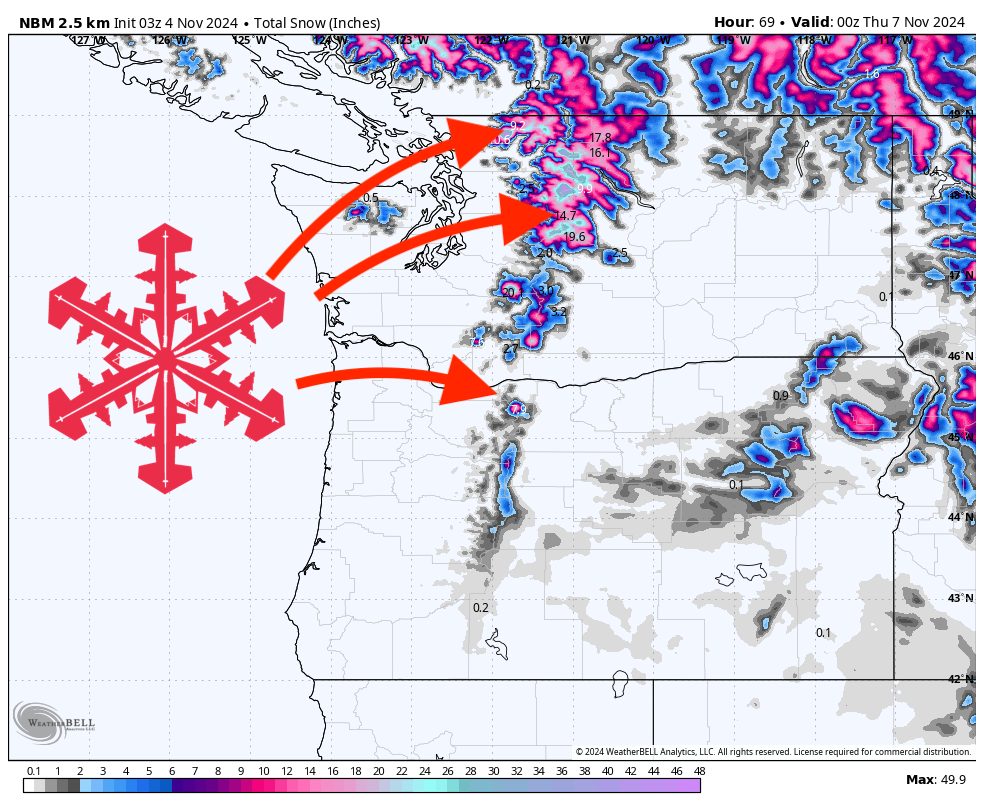
A winter storm is set to impact the Washington Cascades beginning Monday morning, bringing substantial snowfall primarily to northern regions. Snowfall will commence in northern Washington and spread south and east throughout the day, with peak snowfall rates occurring early Monday afternoon. As snow levels drop later in the storm, several resorts can expect impressive accumulations, promising excellent early-season conditions.
Storm Timing and Progression
Precipitation is forecast to begin filling into northern Washington on Monday morning. Throughout the day, the system will spread south and east, encompassing more of the Cascades. Snowfall rates are expected to peak early Monday afternoon before gradually decreasing over Monday evening. The precipitation will continue to diminish through Monday night and into Tuesday morning, with the storm largely concluding by Tuesday evening.
Snow Levels and Temperature Trends
Initial snow levels will start around 4,000 to 4,500 feet near Mt. Baker and approximately 5,000 feet further south by Mt. Hood. As the storm progresses, colder air will infiltrate the region, causing snow levels to drop. By the latter part of the storm, snow levels are expected to decrease to around 2,500 to 3,000 feet near Mt. Baker and about 4,000 feet near Mt. Hood. This decline will enhance snowfall at mid-mountain elevations and improve snow quality.
Snowfall Totals and Regional Impacts
The heaviest snowfall will be confined to Washington and the northern tip of Oregon, with most of the Oregon Cascades receiving minimal snow from this system. Expected snowfall totals at mid-mountain elevations are as follows:
- Mt. Baker: 10–18 inches
- Stevens Pass: 8–15 inches
- Alpental: 6–12 inches
- Crystal Mountain: 4–7 inches
- Timberline: 4–10 inches
- Mt. Bachelor: Trace to 2 inches
Resorts in northern Washington, such as Mt. Baker and Stevens Pass, are poised to receive the most significant accumulations. Further south, snowfall amounts will taper off, with the Oregon Cascades seeing considerably less impact.
Extended Outlook
After the storm concludes by Tuesday evening, a period of quieter weather is anticipated until the next storm rolls into the PNW on Friday/Saturday. Details remain fuzzy, but unfortunately, that storm looks warm and wet; likely rain at the ski areas. Plenty of time for the forecast to change, so keep you fingers crossed for a colder storm than what the models are currently showing!