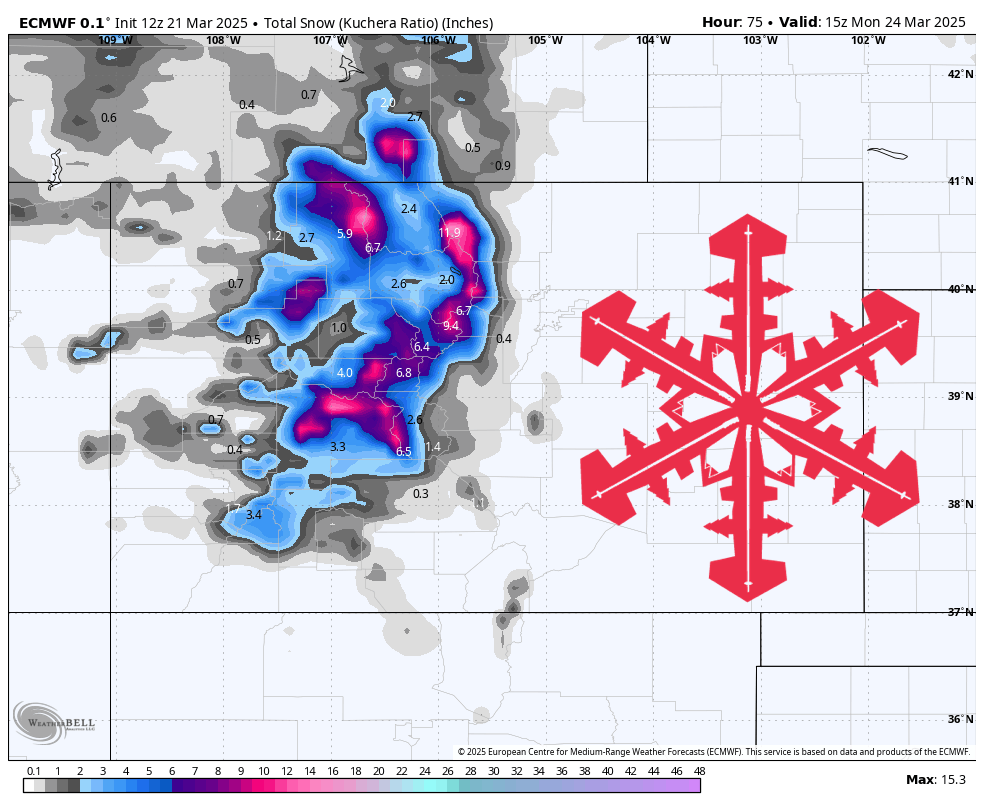
A spring storm will bring fresh powder to Colorado’s mountains from Friday night into Sunday, followed by a return to mostly dry and mild weather next week. Additional accumulations are most likely across the northern and central mountains, with overall moderate snow ratios delivering decent-quality snow. Gusty winds may create brief whiteout conditions on Saturday, especially at higher elevations, before ridging dominates through the midweek period.
A new round of snowfall will arrive late Friday night as moisture streams into the northern and central Colorado mountains. Expect light to moderate snow to develop in the pre-dawn hours, becoming steadier by Saturday morning. Snow ratios will often be in the 10–14:1 range, supporting a reasonably soft and buoyant feel underfoot. Gusty winds will accompany the incoming storm, occasionally reaching 35–50 mph at higher elevations, so anticipate some blowing snow and drifting in open areas. Saturday will bring continued snowfall and occasionally heavier bursts, especially in areas north of I-70.
By Sunday, lingering light snow will persist through the morning in the northern mountains, gradually diminishing by midday. Some spots, particularly around the Park Range, could squeeze out another inch or two before clearing sets in. High pressure then builds strongly into Colorado by late Sunday, ushering in warmer temperatures and mostly dry conditions through midweek. Daytime highs in lower elevations will climb rapidly, reaching well above normal, while only spotty mountain showers may pop up early in the workweek.
Looking further ahead, the medium-range outlook suggests a generally dry pattern over the southwestern states, including much of Colorado. While portions of the northern tier and Northeast could remain active, Colorado’s high country appears poised for warmer than average temperatures. With snowpack levels still quite healthy, the primary concern will be mild afternoons and a potential softening of snow surfaces at lower elevations. Overall, expect spring-like conditions to prevail after this weekend’s round of fresh powder.
Resort Forecast Totals
- Steamboat – 5″-8″ Fri night (03/21) – Sun (03/23)
- Loveland/Arapahoe Basin – 4″-6″ Fri night (03/21) – Sun night (03/23)
- Winter Park – 4″-6″ Fri night (03/21) – Sun night (03/23)
- Crested Butte – 3″-5″ Fri night (03/21) – Sun (03/23)
- Snowmass – 3″-5″ Fri night (03/21) – Sun (03/23)
- Vail/Beaver Creek – 3″-5″ Fri night (03/21) – Sun night (03/23)
- Copper Mountain/Breckenridge – 2″-4″ Fri night (03/21) – Sun (03/23)
- Monarch – 1″-3″ Fri night (03/21) – Sat night (03/22)
- Telluride – 1″-2″ Fri night (03/21) – Sun (03/23)