This forecast was completed at 3:00 a.m. Wednesday, October 16
Forecast Summary
This has been a very mild fall in Utah, but a big change is coming on Thursday and Friday.
A cold front will move through the state Thursday night, bringing valley rain and high mountain snowfall. Check mountain webcams on Friday morning as the storm wraps up.
Beyond this storm, we’ll see another stint of dry weather. Chances for snow may return as soon as the later half of next week.
Short Term Forecast
Our first solid storm of the 2024-25 winter season is on the doorstep.
Cooler air and a few waves of shower activity will impact the northern half of Utah on Thursday. I expect snow levels to struggle to fall much below 9,500’, but lightly accumulating snow can be expected in the highest terrain.
A strong cold front will move in Thursday night, bringing a burst of valley rain and heavy mountain snowfall. Periods of snow will last into Friday morning, slowly tapering off through the day. Much colder air will move in behind the front, briefly dropping snow levels as low as 5500-6000’ as the storm ends.
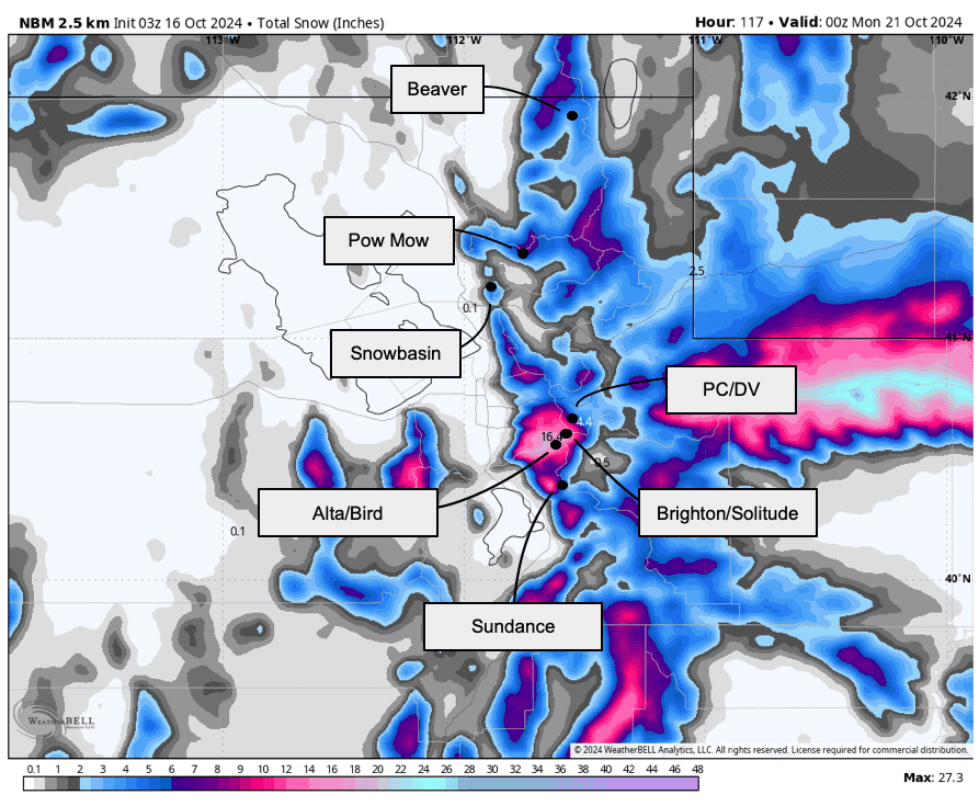
We’ll be dry again by Friday night, but not before some healthy snowfall. Upper elevations of the Park City Ridgeline & both Cottonwood Canyons could all see around a foot of fresh snow.
Snow totals from this storm will be very elevation-sensitive. With that in mind, here’s what I expect to see:
- 10-15” for Alta & Snowbird (monitor Alta’s snow live here)
- 10-15” for Brighton and Solitude
- 8-14” at Park City resorts
- 12-18” for Brian Head, Eagle Point
- 3-4” for Snowbasin & Powder Mountain
Long Range Prospects
Temperatures will climb to above normal values by the weekend and stay warm for most of next week.
Generally, we look to stay pretty mild and dry until the last few days of October. This is unfortunate news for future avalanche conditions – new snow from the incoming storm may sit and degrade in the shady upper elevations for longer than we’d like. I’m concerned it’ll prove to be a poor foundation for the season’s snowpack.