A highly amplified weather pattern is setting up across North America for the next several weeks, shaping snow chances in some classic winter hot spots—while leaving others lacking.
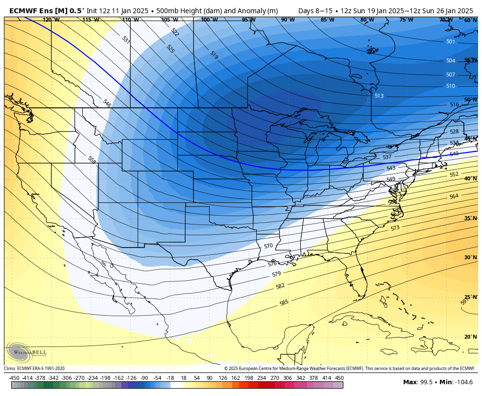
Here’s the breakdown as we move through January and beyond: The persistent ridge over the West and trough over the East will drive much of the temperature and precipitation pattern in the coming weeks.
General Pattern: Ridge West, Trough East

Throughout much of January, there is a strong indication of a persistent ridge of high pressure over the Western United States and a southward dipping trough over the Central and Eastern United States. Such a pattern often sets the stage for warmer-than-normal conditions across much of the West and the Southern Plains, along with colder-than-normal conditions for the Central and Eastern U.S., including a swath from the Northern/Central Plains into the Southeast and portions of the East Coast.
In addition, this ridge/trough setup can direct more Pacific moisture into the Pacific Northwest, while limiting big storm systems in the Desert Southwest and Southern California. Overall, this leads to an active storm track for some areas and relatively dry conditions for others.
Pacific Northwest & Northern Rockies
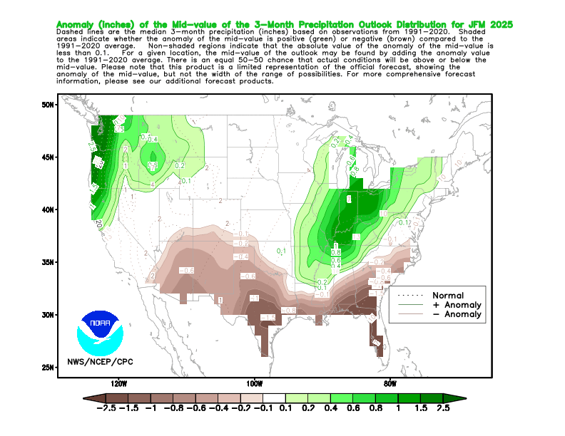
Above-average precipitation is favored in these regions through January, thanks to the storm track riding the ridge’s northern flank. This bodes well for the Washington and Oregon Cascades, as well as the mountains of northern Idaho and western Montana. Frequent shots of moisture should deliver periodic fresh snowfall—some of which could be quite substantial if storms align properly with cold enough air aloft.
The farther inland you go (especially into Idaho and Montana), the potential remains good for repeated moderate snow events. Conditions look solid for continued reloads of fresh powder, so keep an eye out for those quick-hitting impulses.
California’s Sierra Nevada
While the Pacific Northwest stays active, signals for Northern and Central California are more mixed. Central and southern parts of the Sierra may see fewer big storm events overall. However, any eastward shift in the ridge could open a short-lived window for a decent storm or two.
Temperatures are likely to average near or slightly above normal, so snow lines may fluctuate more than desired. Expect good conditions in higher elevations when storms do arrive, but don’t be surprised if lower elevations see more rain/snow mix events.
Intermountain West (Utah, Colorado, Wyoming)
Ridging favors warmer-than-normal conditions for many areas, especially from Utah southward. Still, storms cresting the ridge and dropping into the Rockies could bring a handful of decent snow days, especially to northern Utah and northwest Colorado, and into western Wyoming.
Southern Colorado is at risk for longer dry spells, though small disturbances sliding under the ridge can still pop up. Keep an eye out for short-notice storms that may produce enough snow to refresh the slopes between longer breaks.
Southwest U.S.
A drier pattern is expected across Arizona, New Mexico, and southern portions of Utah and Colorado. Any mountain snow there will likely be more sporadic, with the best chances tied to marginal storms slipping under the ridge.
Above-normal temperatures may also limit lower-elevation snowfall. Expect the best bets for powder at higher elevations and be prepared for inconsistent intervals of snow.
Northern and Central Plains, Midwest, and Great Lakes
A colder-than-normal forecast translates to potential for occasional snow events as storms slip east of the Rockies. Some seasonal signals suggest that the Great Lakes region in particular may tap into periodic moisture, boosting lake-effect or synoptic snowfall episodes.
Along with the temperatures, timing and track of each storm system will determine who gets the fresh accumulations. Northern Plains states may see quick-hitting clippers that bring lighter but frequent snowfall.
Northeast and Mid-Atlantic
Troughing over the eastern half of the country signals below-normal temperatures, which could set the stage for snow events. However, whether that lines up with substantial moisture remains somewhat uncertain.
Short-lived cold snaps could coincide with coastal or clipper systems to produce moderate snow for interior and higher-elevation areas of the Northeast. Farther south, the Mid-Atlantic’s snow prospects hinge on timely phasing of cold air and Atlantic moisture.
Alaska
The forecast leans toward above-normal temperatures for much of southern and southwestern Alaska, with greater chances for snowfall in western and northern sections of the state. Southeast Alaska could see near or slightly below-normal precipitation, but confidence is mixed.
Elevated ridging could pull warmer Pacific air inland, limiting big snow events in some southern regions. That said, a few colder systems can still swing in and create decent snowfall, especially farther north.
Looking Beyond January
While the current pattern is expected to persist through January, there could be gradual shifts in February. Lingering impacts resembling a weak La Niña may keep the Pacific Northwest and northern tier more active, while much of the southern tier likely continues to see below-normal precipitation.
If the ridge in the West loosens its grip, we may see an increase in storms further south by late winter. However, signs of that remain modest, and transitions to more neutral conditions may reduce confidence in strongly directional forecasts.
Bottom Line
Expect the West to stay mild overall, with the best odds of consistent snowfall from the Pacific Northwest into the Northern Rockies. The Sierra, Intermountain West, and Southwest may be more hit-or-miss, with higher terrain still seeing some notable snow, but longer breaks between storms.
Cold air over the Central and Eastern U.S. could set the stage for snow events, though timing with moisture remains key. The Great Lakes and Northern Plains look to be in a good position for multiple shots of snow in the coming month, while those in the East can keep fingers crossed for a few colder and snowier stretches aligning with passing systems.