This summer outlook first appeared on the Farmer’s Almanac
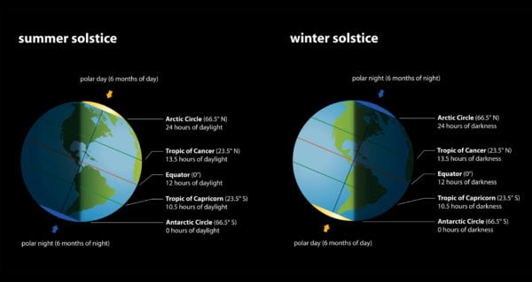
Summer in the Northern Hemisphere officially began on Saturday, June 20, 2020, at 5:44 p.m. EDT, with the arrival of the Summer Solstice. This marked the longest day of the year and the moment when the Sun reaches the Tropic of Cancer, its highest point. For those who live in the Southern Hemisphere, this is the shortest day of the year and the arrival of winter. The solstice happens at the same moment for everyone, everywhere on Earth.

For many, summer is the most anticipated season of the year. But these are uncertain times. We understand that the coronavirus pandemic will most likely put a crimp in plans and summer vacations may be staycations. But we know that many are looking forward to warmer temperatures and seeing nature in full bloom.
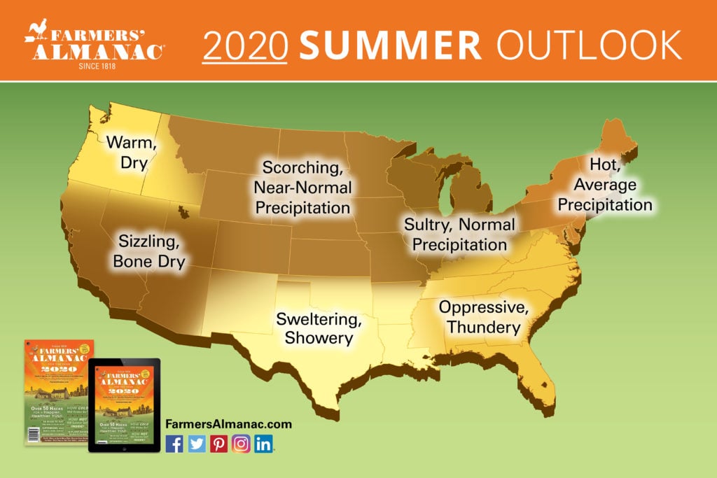
Will summer sizzle or fizzle? Here’s what we’re predicting for the U.S. and Canada.
2020 U.S. Summer Forecast
How Hot Will Summer Be?
Summer starts on a stormy note in most regions. July runs hot for much of the nation, with well-above-normal temperatures predicted.
Summer Weather: Wet or Dry?
Much of the country will see near-normal precipitation, but the far West will be drier-than-normal, and it will be wet across the southern Plains and the Gulf Coast through Florida.
2020 Hurricane Outlook

A hurricane might threaten Florida during the first week of June, just as “meteorological summer” begins, and a subtropical disturbance could affect parts of the Atlantic Seaboard during the third week of June. Then things should quiet down during July and August before ramping up again in mid-September with a tropical storm threat along the Gulf Coast.
A hurricane threat for the mid-Atlantic and Northeast is predicted at the same time. Typically, tropical cyclone activity over the Atlantic and. The Caribbean Sea increases exponentially during the second week of August and reaches its peak on September 10.
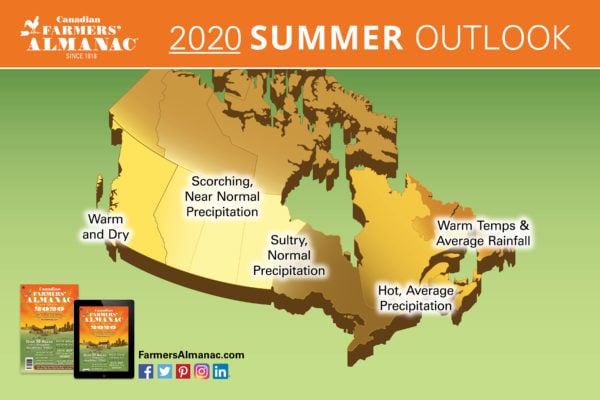
2020 Canadian Summer Forecast
According to the 2020 Canadian Farmers’ Almanac, summer heat will arrive in full force by July with much of the nation sweltering with above to much above normal temperatures. Much of the country will see near-normal precipitation, but the Far West will be drier than normal.

As far as the tropics are concerned, the Maritimes will need to monitor an offshore subtropical disturbance during the third week of June. Then things should quiet down in July and August before ramping up again in mid-September with a hurricane threat for the Maritimes, and another potential hurricane could take a swipe at Cape Race to the Avalon Peninsula just a week later. Typically, tropical cyclone activity over the Atlantic and the Caribbean Sea increases exponentially during the second week of August and reaches its traditional peak on September 10.