The National Weather Service has issued a Winter Weather Advisory for Oregon and Washington. A cold front is moving through, which will turn precipitation from rain to snow.
Mt. Hood is expected to see 3-7″ of new snow today.
NOAA Has Issued A Winter Weather Advisory For:
Oregon
Washington
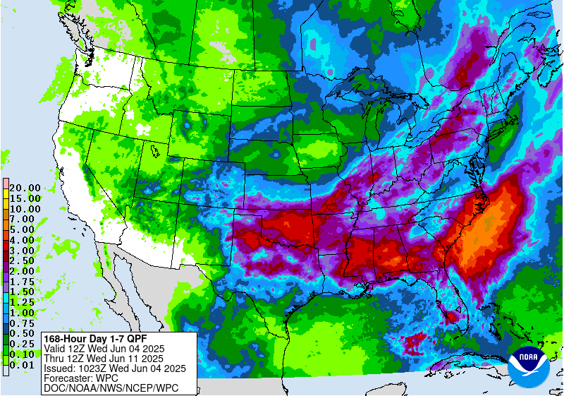
7 day GEM Model shows snow for the West. Image: Tropical Tidbits7 day precipitation totals. Image: NOAA
Snow levels in Oregon are expected to hover around 5,000ft throughout the day today. The heaviest snow accumulations will be above 6,000ft.
Additional Storm Info:
Fire extinguisher is on the way. Image: NOAA Portland, ORSnow is in the forecast for Timberline Lodge, OR. Image: NOAA
Mt. Hood, OR: 3-7″ of Snow Above 6,000ft Today
* SNOW ACCUMULATIONS...3 to 7 inches in the southwest Washington
 Cascades and mainly around Mount Hood in the north Oregon
 Cascades.
- NOAA Portland, OR
Wet & Cool weather expected in Oregon this week. Image: NOAA Medford, ORFlood Risk Today in Oregon. Image: NOAA Portland, OR
Mt. Hood Winter Weather Advisory:
URGENT - WINTER WEATHER MESSAGE
National Weather Service Portland OR
202 AM PDT Wed Sep 20 2017
Including the cities of Government Camp,
Coldwater Ridge Visitors Center, Mount St. Helens,
and Wind River Valley
...WINTER WEATHER ADVISORY IN EFFECT UNTIL 2 PM PDT THISAFTERNOON...
The National Weather Service in Portland has issued a Winter
Weather Advisory for snow, which is in effect until 2 PM PDT this
afternoon.
* TIMING...Until 2 pm PDT this afternoon.
* SNOW LEVEL...Around 5000 feetin the southwest Washington
Cascades and 5500 feet in the north Oregon Cascades.
* SNOW ACCUMULATIONS...3 to 7 inchesin the southwest Washington
Cascades and mainly around Mount Hoodin the north Oregon
Cascades.
* IMPACTS...Roads above 5500 to 6000 feet will be snow covered and slick. Use chains or traction devices.
6-10 day temperature outlook. Image: NOAA6-10 day precipitation outlook. Image: NOAA