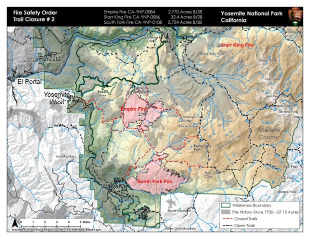
Yosemite National Park in California is on fire.
6 Fires are currently burning in and very near the park:
- Railroad Fire = 1,000 acres
- South Fork Fire = 5,191 acres
- Empire Fire = 4,125 acres
- Starr King Fire = 32 acres
- Porcupine Fire = 2.2 acres
- Yosemite Creek Fire = .75 acres
- Knob91 Fire = .39 acres
Highway 41 between Oakhurst & Yosemite is closed.
Glacier Point Road is closed.
Many trails are closed.
Mandatory evacuations are in place for the community of Sugar Pine and Sugar Pine Camp with an evacuation advisory for the community of Fish Camp.
RAILROAD FIRE:
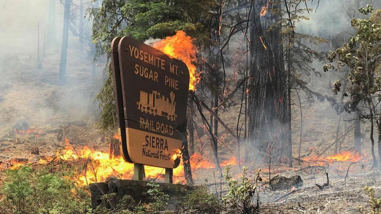
Approximate Location
37.434 latitude, -119.651 longitude
Incident Overview
Railroad Fire, Sierra National Forest (NF), California.
The Railroad Fire started August 29, 2017 at approximately 1300 hrs. West of Highway 41, near the community of Sugar Pine, South of Yosemite National Park and Fish Camp.
It is a vegetation fire burning on the Sierra NF. The fire is burning in steep terrain, with difficult access and heavy fuel loading. Potential for this fire is high.
Mandatory evacuations are in place for the community of Sugar Pine and Sugar Pine Camp with an evacuation advisory for the community of Fish Camp.
There are 100 structures threatened.
Highway 41 is in a hard closure from Westphal to the South entrance to Yosemite National Park. Yosemite visitors are to use Highway 49 and Highway 140 for entrance to the National Park.
Presently the fire has consumed approximately 1000 acres and is 5% contained, cause of the fire is under investigation.
Resources on this fire consist of 26 Fire Engines, 7 Hand Crews, 3 Helicopters, 10 Air Tankers
Total Personnel: 350
Assisting Agencies: CAL FIRE, Madera County Sheriffs Office and Madera County Fire.
Additional resources are on order.
Tomorrow at approximately 1000hrs a Type 2 Incident Command Team (IMT), will take over the incident command from the Sierra NF.
Basic Information
| Current as of | 8/29/2017, 9:49:48 PM |
|---|---|
| Incident Type | Wildfire |
| Cause | Unknown |
| Date of Origin | Tuesday August 29th, 2017 approx. 01:00 PM |
| Location | West of Highway 41, near the community of Sugar Pine |
| Incident Commander | Sierra National Forest |
Current Situation
| Total Personnel | 350 |
|---|---|
| Size | 1,000 Acres |
| Percent of Perimeter Contained | 5% |
| Fuels Involved | Brush and Timber |
SOUTH FORK FIRE:
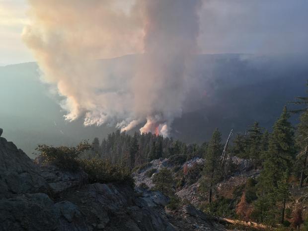
Approximate Location
37.538 latitude, -119.598 longitude
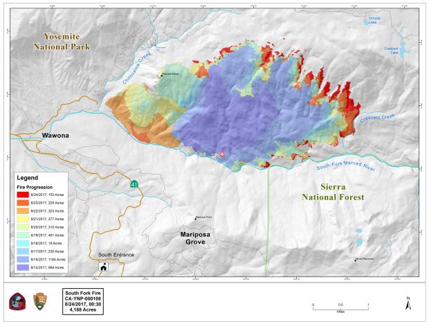
Incident Overview
The north flank of the fire was the most active yesterday as it burned into heavy pockets of fuel. The south and west flanks of the fire are contained, some smoke will be visible as logs and brush burn in the interior. Crews will continue to patrol and monitor the flanks closest to the community of Wawona and Mariposa Grove. Crews are continuing containment strategies on the north-west edge of the fire and to keep fire south and south-east of Chilnualna Creek. The north and east flank of the fire is continuing to burn in the wilderness, and will be monitored by aircraft due to inaccessible and steep terrain. As fire continues into the high country it will hit some pockets of heavy vegetation with little fire history but slow down with natural granite barriers and sparse vegetation which will limit smoke production. This high country wilderness area has few high values at risk.
Basic Information
| Current as of | 8/29/2017, 2:47:32 PM |
|---|---|
| Incident Type | Wildfire |
| Cause | Unknown |
| Date of Origin | Sunday August 13th, 2017 approx. 02:30 AM |
| Location | .75 mile east of the community of Wawona |
| Incident Commander | Ty Crowe IC3 |
| Incident Description | Supression |
Current Situation
| Total Personnel | 101 |
|---|---|
| Size | 5,191 Acres |
| Percent of Perimeter Contained | 44% |
| Fuels Involved | Timber (Litter and Understory) Brush (2 feet) |
| Significant Events | The following trail and area closures are in place until further notice:
•The Swinging Bridge Trail on both the north and south sides of the South Fork of the Merced River. •The Chilnualna Falls Trail from Wawona Trailhead to the top of Chilnualna Falls. •The two mile connecting trail heading north from the top of Chilnualna Falls to the intersection of the Buena Vista Trail. •The Chilnualna Creek Trail from the top of Chilnualna Falls east to the intersection of the Buena Vista and Buck Camp trails (Just east of Johnson Lake). •Turner Meadow Trail •Turner Meadow intersection east to Buena Vista trail •Off-trail areas in the vicinity of the South Fork Fire Area, including the swimming holes north of Chilnualna Creek. • All climbing routes on and around Wawona Dome are closed. |
Outlook
| Planned Actions | Mop up and suppression repair on the west flank of the fire. Monitor and check the fire spread near the S. fork of the Merced River on the SE side of the fire. Monitor fire spread on the north and east flanks. |
|---|---|
| Remarks | Crews continue to hot spot and cold trail the southeast portion (Div J) in an effort to halt the eastern spread of the fire. Weather is forecasted to get hotter and drier with expected increases in fire behavior until the high pressure system moves out and clouds and moisture move over fire area.The fire is located in the South Fork of the Merced River, with very steep and inaccessible terrain. |
Current Weather
| Weather Concerns | A strong upper level ridge of high pressure centered over the Great Basin will continue to bring well above normal temperatures and light, terrain-driven winds to the fire through Tuesday with little diurnal change in humidity. A southwesterly flow aloft will become established over the fire by this afternoon and remain westerly through midweek as a weak upper level trough passes by to our north. Although a few thunderstorms could pop up over the higher elevations of Yosemite Tuesday and Wednesday, they will remain well east of the fire. |
|---|
EMPIRE FIRE:
Approximate Location
37.644 latitude, -119.618 longitude
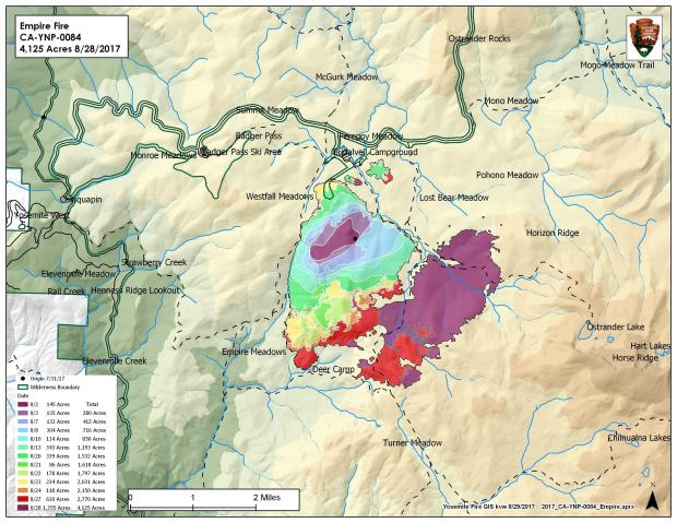
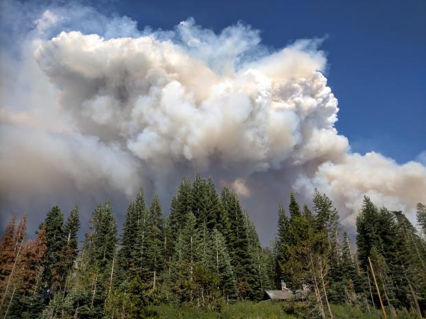
Due to a very dry air mass fire activity increased yesterday on the eastern flanks of the fire burning in heavy pockets of down and dead vegetation. The west and northwest flanks of the fire are contained and showed minimal activity. Fire crews are implementing a perimeter control strategy for the north, west, and southern flanks of the fire to protect Bridalveil Campground, Yosemite Ski and Snowboard Area, Yosemite West subdivision, Wawona Road (Highway 41), and Glacier Point road. Strategy for the east flank of the fire is to steer fire east deeper into the wilderness where there is sparse vegetation and natural granite barriers which will slow spread and limit smoke production. This high country wilderness area is very steep and rugged and has few high values at risk.
Fire management personnel is implementing this strategy on three sides of the fire to limit further smoke production in heavy fuels..
Today crews will be working to secure the Deer Camp trail from Alder Creek east for 3/4 of a mile. Glacier Point road is closed to the public due to fire fighter safety to conduct tree felling and vegetation clearance. Additional crews and engines are on order to support these operations.
Basic Information
| Current as of | 8/29/2017, 2:04:58 PM |
|---|---|
| Incident Type | Wildfire |
| Cause | Lightning/natural |
| Date of Origin | Tuesday August 01st, 2017 approx. 08:45 AM |
| Location | 1 Mile east of Badger Pass Ski Area, directly adjacent to Bridalveil Crk. Campground Bridalveil in Yosemite’s Wilderness |
| Incident Commander | Tom Garcia, ICT3 |
| Incident Description | Management |
Current Situation
| Total Personnel | 75 |
|---|---|
| Size | 4,125 Acres |
| Percent of Perimeter Contained | 40% |
| Fuels Involved | Red Fir Timber (Litter and Understory), Dormant Brush, Hardwood Slash
Pockets of green leaf manzanita and chinquapin brush as well as heavy dead and down material |
| Significant Events | The following trail and area closures are in place until further notice:
• Glacier Point Road • Bridalveil Campground • Ostrander Trail • Bridalveil Trail • Alder Creek Trail • Mono Meadow Trail • Turner Meadow Trail All closed trailheads and junctions will be posted with a trail closure order and map. |
Outlook
| Planned Actions | Continue to implement firing operations from the area of Turner Meadow Junction toward Deer Camp
with the intention of tying the firing operation into Deer Camp and securing the southern flank of the fire to the western flank of the fire by end of shift 8/31/17. Continue to monitor and secure the northern flank of the fire above the Bridalveil Creek Campground. Continue to check up and secure the perimeter of the 50 acre spot fire to the east of Bridalveil Creek Campground. |
|---|---|
| Projected Incident Activity | 12 hours: Begin firing on the south flank from the area of Tuner Meadows toward Deer Camp
24 hours: Continue firing operation on the south flank from the area of Turner Meadows toward Deer Camp. 48 hours: Complete all firing operations by end of shift hold line and monitor fire. 72 hours: Continue to reevaluate fire behavior hold and monitor fire . Crews will be strategically positioned to monitor fire and allow the fire to naturally progress east further into the wilderness. |
Current Weather
| Weather Concerns | A strong upper level high pressure center over the great basin
will continue to bring above normal temperatures and light, terrain-driven winds to the district through the weekend with little diurnal change in humidity’s. A weak system moving through Northern California will slightly cooler temperatures by a few degrees on Wednesday. There is a slight chance of afternoon/early evening thunderstorms over the higher elevations of the southern Sierra Nevada through Thursday. |
|---|
ALL FIRES IN YOSEMITE:
by Yosemite National Park
Fire Update August 29th, 2017
|
August 29, 2017
There are multiple fires burning in Yosemite National Park’s wilderness Smoke will be present due to a high pressure system which brings higher temperatures and lower relative humidities. Thunderstorms are possible over the high country. Thunderstorms bring gusty winds and hazardous lightning. South Fork Discovered: 8/13/17 The north flank of the fire was the most active yesterday as it burned into heavy pockets of fuel. The south and west flanks of the fire are contained, some smoke will be visible as logs and brush burn in the interior. Crews will continue to patrol and monitor the flanks closest to the community of Wawona and Mariposa Grove. Crews are continuing containment strategies on the north-west edge of the fire and to keep fire south and south-east of Chilnualna Creek. The north and east flank of the fire is continuing to burn in the wilderness, and will be monitored by aircraft due to inaccessible and steep terrain. As fire continues into the high country it will hit some pockets of heavy vegetation with little fire history but slow down with natural granite barriers and sparse vegetation which will limit smoke production. This high country wilderness area has few high values at risk. Area and trail closures are in place follow posted closure orders and maps. Empire Discovered: 8/1/17 Due to a very dry air mass fire activity increased yesterday on the eastern flanks of the fire burning in heavy pockets of down and dead vegetation. The west and northwest flanks of the fire are contained and showed minimal activity. Fire crews are implementing a perimeter control strategy for the north, west, and southern flanks of the fire to protect Bridalveil Campground, Yosemite Ski and Snowboard Area, Yosemite West subdivision, Wawona Road (Highway 41), and Glacier Point road. Strategy for the east flank of the fire is to steer fire east deeper into the wilderness where there is sparse vegetation and natural granite barriers which will slow spread and limit smoke production. This high country wilderness area is very steep and rugged and has few high values at risk. Area and trail closures are in place including: Glacier Point road, Bridalveil Campground, and multiple trail closures. Starr King Discovered: 8/2/17 Activity has picked up and smoke will be visible from Glacier Point, Washburn Point, and Sentinel Dome. Yosemite Creek Discovered: 8/3/17 Porcupine Discovered: 8/2/17 Knob 91 Discovered: 8/4/17 |
When is BLM sending support?
Bad journalism. The Railroad fire is not in Yosemite. The park is the size of Rhode Island, and, yes, there are fires in the wilderness because of lightning strikes, but your headline is inflammatory and unnecessary. Fire is a natural part of a wilderness and most of them don’t approach populated parts of the park. The South Fork and Empire fires were exceptions. Some roads have been closed and are opening up today. I notice you use YNP reports to bolster your story without really identifying where all these fires are. Most are in unpopulated wilderness with no threat to human life and little to no impact on visitor areas.
Thanks for the note, Judith. It is very clearly stated that these fires are in or nearby Yosemite. Each fire is individually located in the article including GPS coordinates. We also included all the maps we could find that clearly show exactly where these fires are located. Thanks, miles
I hope things are good on the otherside near yosemite park campground, my sister works there, Amy, an my mom an sister live still on otherside. Prayers to my family up there. Please Father keep them safe
I saw the original Yosemite Firefall.
I think that you meant ‘ Trails are closed in Yosemite.’
I saw that too, LOL. Someone didn’t proofread..