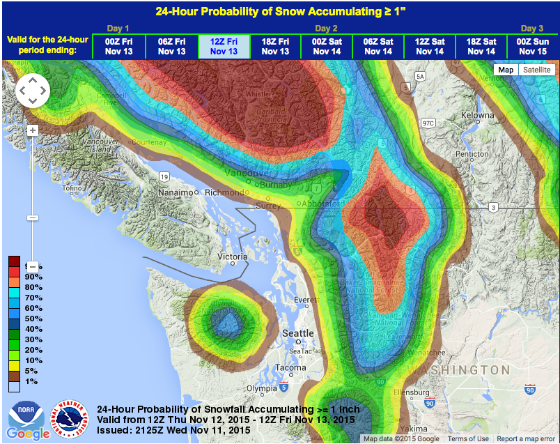
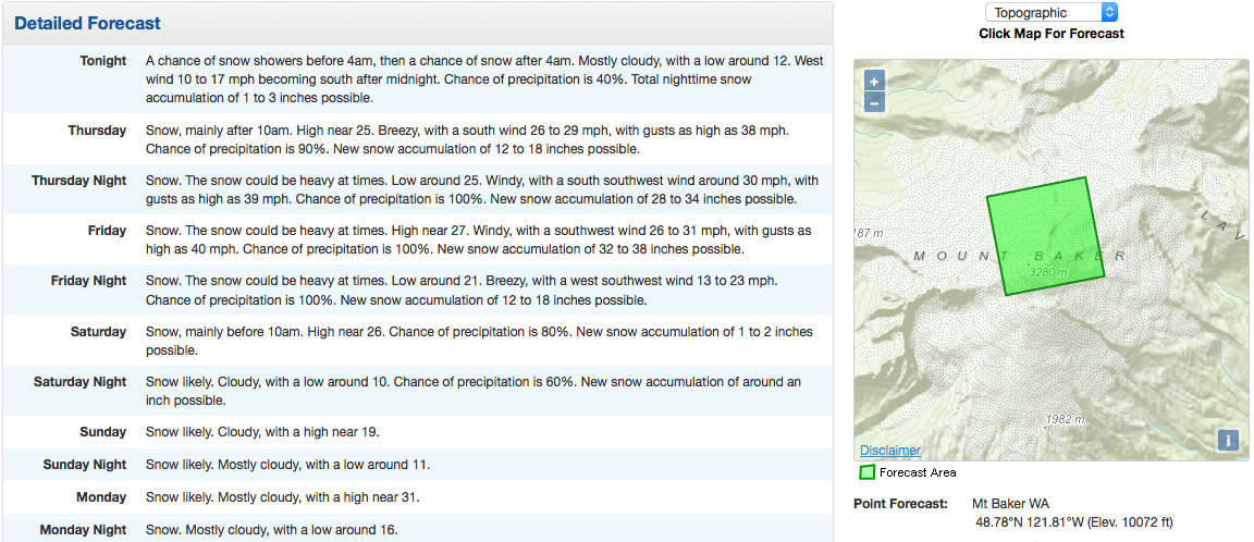
A powerful storm is about to clobber Washington state with waves up to 22-foot tall, winds up to 50mph, and snow up to 110-inches deep on 10,781-foot Mount Baker all in the next 2 days.
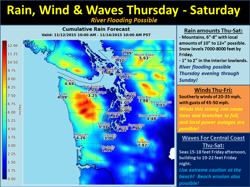
That’s 22-foot waves, 50mph winds, and up to 110-inches of snow all in 2 days… Wow.
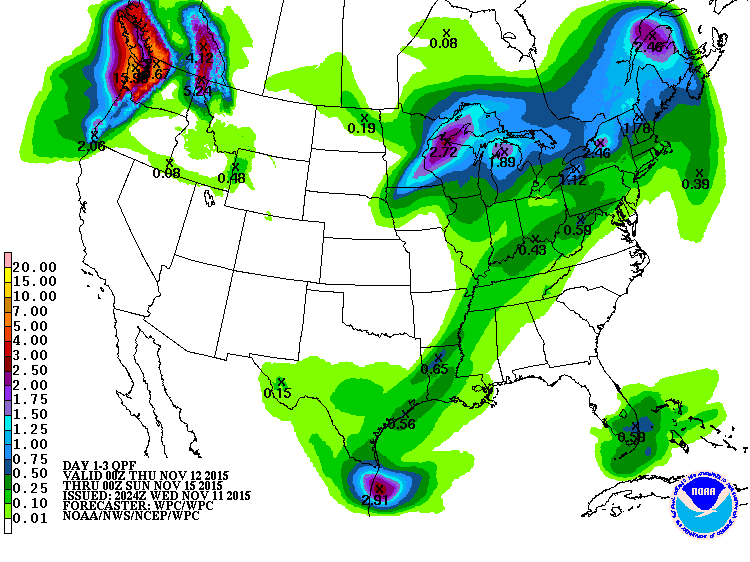
“The mountains could receive 6 to 8 inches of rain with locally higher amounts of 10 to 12+ inches possible…
There will also be strong southerly winds of 20-35 mph with gusts of 45-50 mph Thursday through Friday…
Then, there will be large waves of 15 to 18 feet Friday, building to 19 to 22 feet Friday night for the central coast.” – NOAA Seattle, WA today
10-12″ of liquid precipitation would translate to 10-12′ of snow above snow line and snow line is forecast to be no higher than 7,500-feet.
SNOW LEVEL CHART for MT. BAKER:
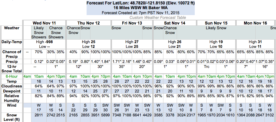
Snow levels are forecast to start low around 2,000-feet tomorrow before rising to about 7,500-feet on Friday during the heaviest precipitation and then dropping back down to 4,000-feet on Saturday. Peaks above 7,500-feet are going to get buried in snow.
Unfortunately, there are no ski resorts in Washington with elevations above 7,000-feet…
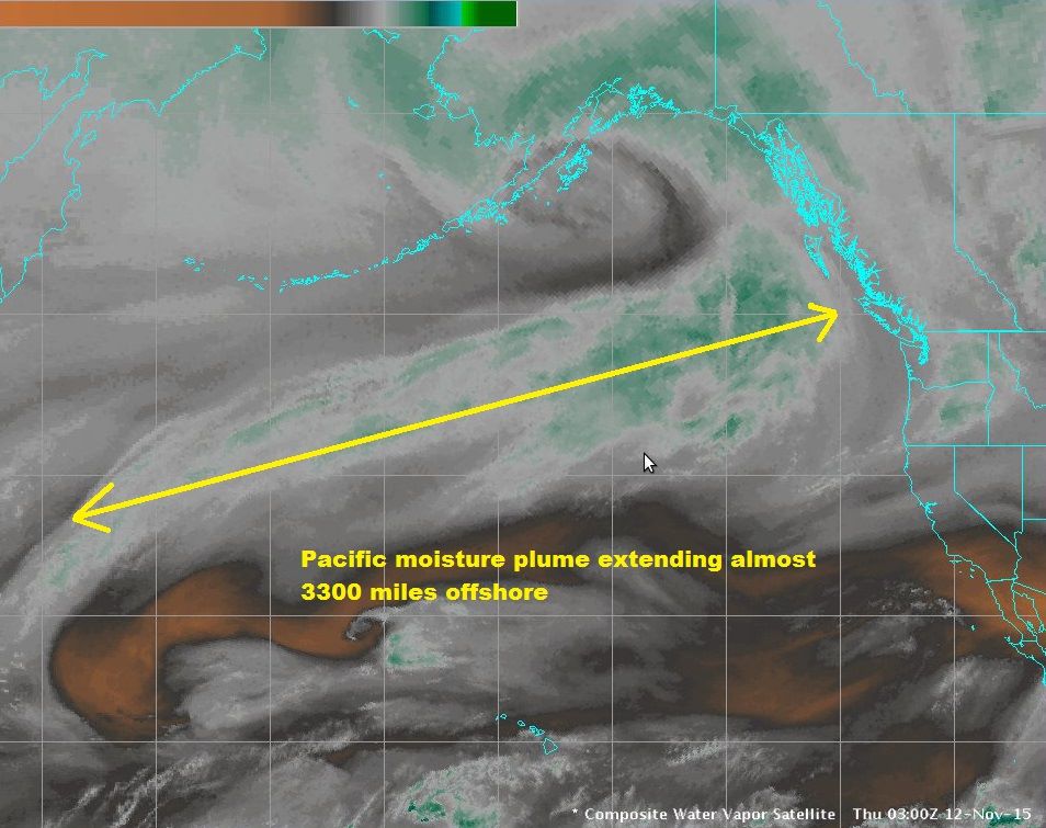
NOAA is saying that the mountains might see up to 10-12″ of rain. If all of that comes in as snow above 7,500-feet, that would translate to 10-12′ of snow…
“We are looking at several concerns with the weather for Thursday through Saturday. First, there will be a lot of rain. The mountains could receive 6 to 8 inches of rain with locally higher amounts of 10 to 12+ inches possible, which could lead to river flooding Thursday evening through Sunday morning. The lowlands are expected to get 1 to 2 inches during this time. There will also be strong southerly winds of 20-35 mph with gusts of 45-50 mph Thursday through Friday, which can cause trees and branches to fall, and cause local power outages. Then, there will be large waves of 15 to 18 feet Friday, building to 19 to 22 feet Friday night for the central coast. This will lead to high surf conditions at the beaches, with beach erosion possible in some areas. Keep up with the latest forecasts and stay safe!” – NOAA Seattle, WA today
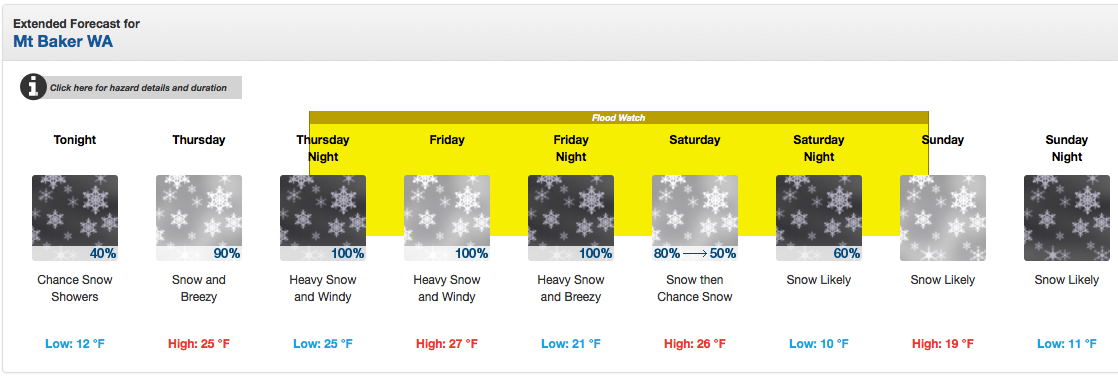
Please be careful out there, Washington. A Flood Watch has been issued for a huge swath of the state. If you drive up on a flooded roadway, “Don’t Drown, Turn Around.”
**Update: A Winter Weather Advisory has been issued at 4am Thursday that states that the road to Mt. Baker and the road to Paradise on Mt. Rainier will see 3-11″ of snow today below 5,000-feet before snow levels rise above 5,000-feet. See full advisory below:
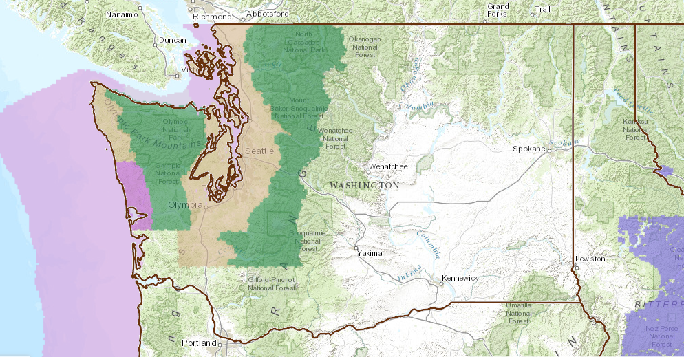
WINTER WEATHER ADVISORY:
URGENT - WINTER WEATHER MESSAGE
NATIONAL WEATHER SERVICE SEATTLE WA
357 AM PST THU NOV 12 2015

CASCADES OF WHATCOM AND SKAGIT COUNTIES-
CASCADES OF PIERCE AND LEWIS COUNTIES-

...WINTER WEATHER ADVISORY IN EFFECT FROM 10 AM THIS MORNING TO 8 PM
PST THIS EVENING...

THE NATIONAL WEATHER SERVICE IN SEATTLE HAS ISSUED A WINTER WEATHER
ADVISORY...WHICH IS IN EFFECT FROM 10 AM THIS MORNING TO 8 PM PST
THIS EVENING.

* SOME AFFECTED LOCATIONS...MOUNT BAKER HIGHWAY...THE ROAD TO
  PARADISE ON MOUNT RAINIER.

* TIMING...SNOW WILL DEVELOP LATE THIS MORNING AND CONTINUE THROUGH
  EARLY THIS EVENING...BEFORE CHANGING TO RAIN.

* ACCUMULATIONS...3 TO 11 INCHES OVER MOUNT BAKER AND 2 TO 8
  INCHES AROUND PARADISE ON MOUNT RAINIER...BEFORE THE SNOW
  CHANGES TO RAIN THIS EVENING.

* SNOW LEVEL...AROUND 2500 FEET TODAY AT MOUNT BAKER AND AROUND
  3000 FEET AT MOUNT RAINIER TODAY. THE SNOW LEVEL WILL RISE TO
  ABOVE 5000 FEET EARLY THIS EVENING...WITH SNOW CHANGING TO RAIN.

* MAIN IMPACT...WINTER DRIVING CONDITIONS.
***
FLOOD WATCH for WASHINGTON:
FLOOD WATCH
NATIONAL WEATHER SERVICE SEATTLE WA
253 PM PST WED NOV 11 2015

CLALLAM-GRAYS HARBOR-JEFFERSON-KING-LEWIS-MASON-PIERCE-SKAGIT-
SNOHOMISH-THURSTON-WHATCOM-

...FLOOD WATCH IN EFFECT FROM THURSDAY EVENING THROUGH SUNDAY
MORNING...

THE NATIONAL WEATHER SERVICE IN SEATTLE HAS ISSUED A

* FLOOD WATCH FOR PORTIONS OF NORTHWEST WASHINGTON AND WEST CENTRAL
  WASHINGTON...INCLUDING THE FOLLOWING COUNTIES...IN NORTHWEST
  WASHINGTON...CLALLAM...GRAYS HARBOR...JEFFERSON...MASON...SKAGIT
  AND WHATCOM. IN WEST CENTRAL WASHINGTON...KING...LEWIS...PIERCE...
   SNOHOMISH AND THURSTON.

* FROM THURSDAY EVENING THROUGH SUNDAY MORNING

...HEAVY RAIN COULD CAUSE RIVER FLOODING THIS WEEKEND..

HEAVY RAIN IS FORECAST AT TIMES THURSDAY AFTERNOON THROUGH
SATURDAY MORNING. THE CASCADES AND OLYMPICS ARE FORECAST TO
RECEIVE SIX TO EIGHT INCHES GENERALLY...WITH SOME EIGHT TO TEN
INCH BULLSEYES IN THE NORTH CASCADES AND UP TO TWELVE INCHES IN
THE OLYMPICS. THE LOWLANDS ARE FORECAST TO GET ONE TO TWO INCHES.

RAINFALL THIS HEAVY WOULD CAUSE FLOODING ON MANY AREA RIVERS. THIS
INCLUDES ANY RIVERS FLOWING OFF THE CASCADES FROM THE NOOKSACK IN
THE NORTH TO THE COWLITZ IN THE SOUTH. ALSO ANY OLYMPIC PENINSULA
RIVERS COULD FLOOD. EVEN THE RIVERS OF SOUTHWEST WASHINGTON SUCH
AS THE CHEHALIS AND ITS TRIBUTARIES COULD FLOOD. SOME FLOODING
COULD OCCUR AS EARLY AS LATE THURSDAY NIGHT. FLOODING IS LIKELY TO
BE MORE WIDESPREAD ON FRIDAY AND FRIDAY NIGHT. IF SOME OF THE
LONGEST RIVERS FLOOD...THE LOWER REACHES MAY NOT FALL BELOW FLOOD
STAGE UNTIL SUNDAY.

THERE IS STILL CONSIDERABLE UNCERTAINTY ABOUT WHERE THE HEAVIEST
RAIN WILL FALL. RECENT MODEL RUNS SHOW THE HEAVIEST RAIN OVER THE
NORTH CASCADES AND OLYMPICS BUT SOME OLDER RUNS HAD THE HEAVIEST
RAIN OVER THE CENTRAL CASCADES AND EVEN FARTHER SOUTH. SINCE THERE
IS UNCERTAINTY THE FLOOD WATCH COVERS EVERY RIVER FLOWING OFF THE
CASCADES AND OLYMPICS.

PRECAUTIONARY/PREPAREDNESS ACTIONS...

A FLOOD WATCH MEANS CONDITIONS ARE FAVORABLE FOR FLOODING BUT
FLOODING IS NOT IMMINENT OR OCCURRING. MONITOR THE LATEST
FORECASTS FROM THE NATIONAL WEATHER SERVICE AND BE READY TO ACT
QUICKLY IF FLOODING IS OBSERVED OR A WARNING IS ISSUED.
Please add my address to you notify list. Thanks!