
NOAA just released their latest El Nino/La Nina discussion and they’re saying that there is a 75% chance of a La Nina developing this coming Fall and Winter.
“La Niña is favored to develop during the Northern Hemisphere summer 2016, with about a 75% chance of La Nina during the fall and winter 2016-17” – NOAA, today
NOAA issued a La Nina Watch for the USA on April 18th, 2016.
We’ve got our fingers crossed for a Strong La Nina. Strong La Ninas have been very good for snow in the USA.

The last time we had a Strong La Nina was in 2010/11 and the USA got huge snowfall totals. Check out the list below:
2010/11 “Strong La Nina” Snowfall Totals:
- Alpine Meadows, CA = 852″
- Squaw Valley, CA = 811″
- Mt. Baker, WA = 808″
- Alta, UT = 723″
- Mammoth, CA = 668″
- Mt. Bachelor, OR = 665″
- Whistler, B.C. = 622″
- Jackson Hole, WY = 557″
- Jay Peak, VT = 376″

EL NIÑO/SOUTHERN OSCILLATION (ENSO) DIAGNOSTIC DISCUSSION
issued by
CLIMATE PREDICTION CENTER/NCEP/NWS
and the International Research Institute for Climate and Society
12 May 2016
ENSO Alert System Status: El Niño Advisory/ La Niña Watch
Synopsis: La Niña is favored to develop during the Northern Hemisphere summer 2016, with about a 75% chance of La Nina during the fall and winter 2016-17
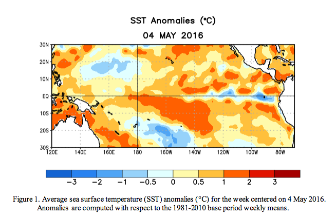
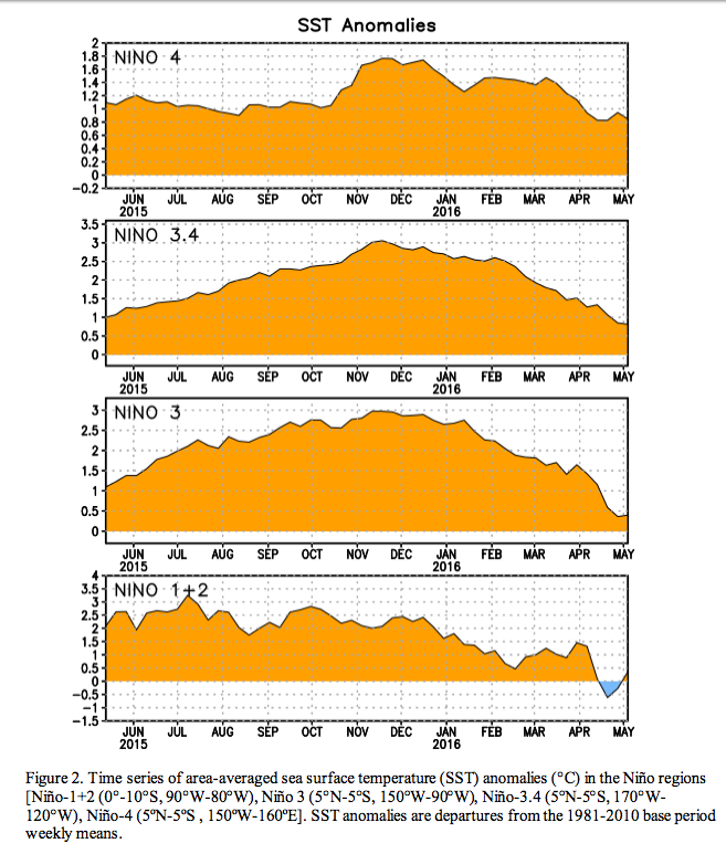
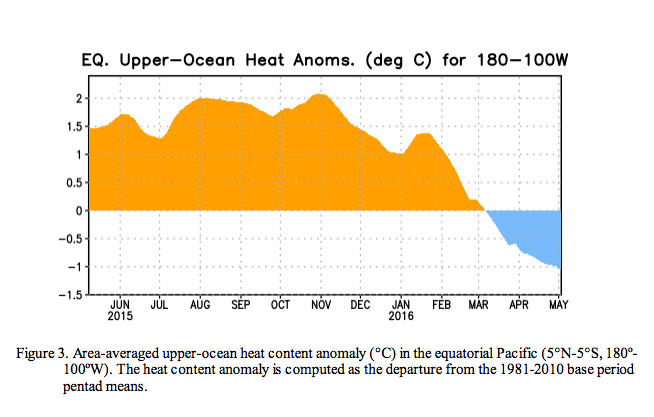
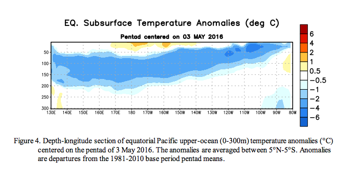
During the past month, sea surface temperature (SST) anomalies decreased across the equatorial Pacific Ocean, with near-to-below average SSTs recently emerging in the eastern Pacific (Fig. 1). The latest Niño region indices also reflect this decline, with the steepest decreases occurring in the Niño-3 and Niño-1+2 regions (Fig. 2). The surface cooling was largely driven by the expansion of below-average subsurface temperatures, which extended to the surface in the eastern Pacific (Figs. 3 and 4). While oceanic anomalies are clearly trending toward ENSO-neutral, many atmospheric anomalies were still consistent with El Niño, such as the negative equatorial and traditional Southern Oscillation indices. Upper-level easterly winds persisted over the central and eastern Pacific, while low-level winds were near average. Enhanced convection continued over the central tropical Pacific and was suppressed north of Indonesia (Fig. 5). Collectively, these anomalies reflect a weakening El Niño and a trend toward ENSO neutral conditions.
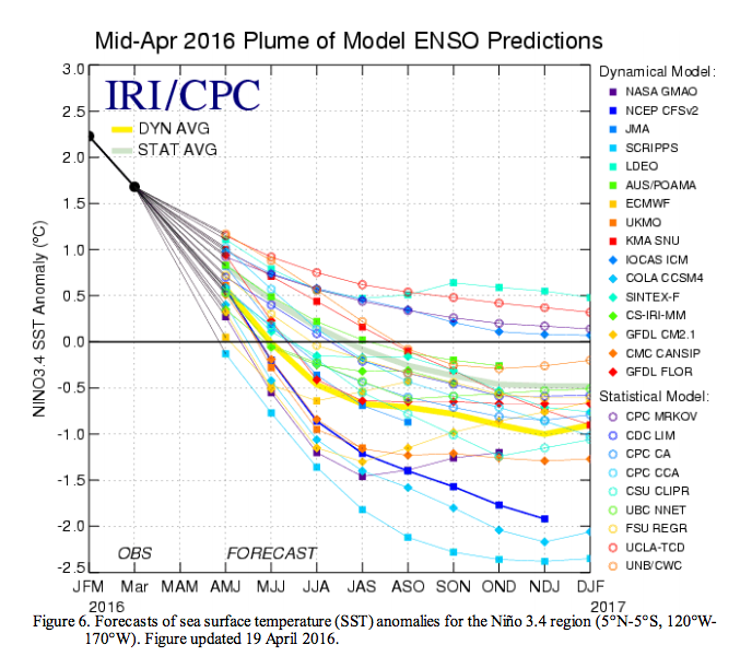
Most models predict the end of El Niño and a brief period of ENSO-neutral by early Northern Hemisphere summer (Fig. 6). The model consensus then calls for increasingly negative SST anomalies in the Niño 3.4 region as the summer and fall progress. However, there is clear uncertainty over the timing and intensity of a potential La Niña (3-month Niño-3.4 SST less than or equal to -0.5°C). The forecaster consensus favors La Niña onset during the summer, mainly weighting the dynamical models (such as NCEP CFSv2) and observed trends toward cooler-than-average conditions. Overall, La Niña is favored to develop during the Northern Hemisphere summer 2016, with about a 75% chance of La Nina during the fall and winter 2016-17 (click CPC/IRI consensus forecast for the chance of each outcome for each 3- month period).
Casey, you must remember how KW was that season. Closer to 900″
Now all they need to do is tell me on what days it will snow 😉