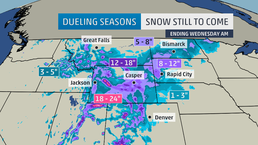
Snowfall forecast for Western USA looking solid… image: theweatherchannel.com
NOAA and The Weather Channel are forecasting “the first larger scale snowstorm of the season” hitting the West this week and dropping up to 24″ of snow in the next 3-days.
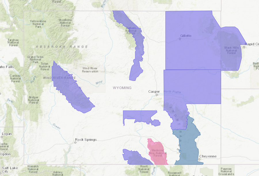
The Weather Channel is calling for 18-24″ of snow in the Wind River Range, WY in the next 3-days.
NOAA has issued Winter Storm Warnings, Winter Storm Watches, and Winter Storm advisories in Wyoming.
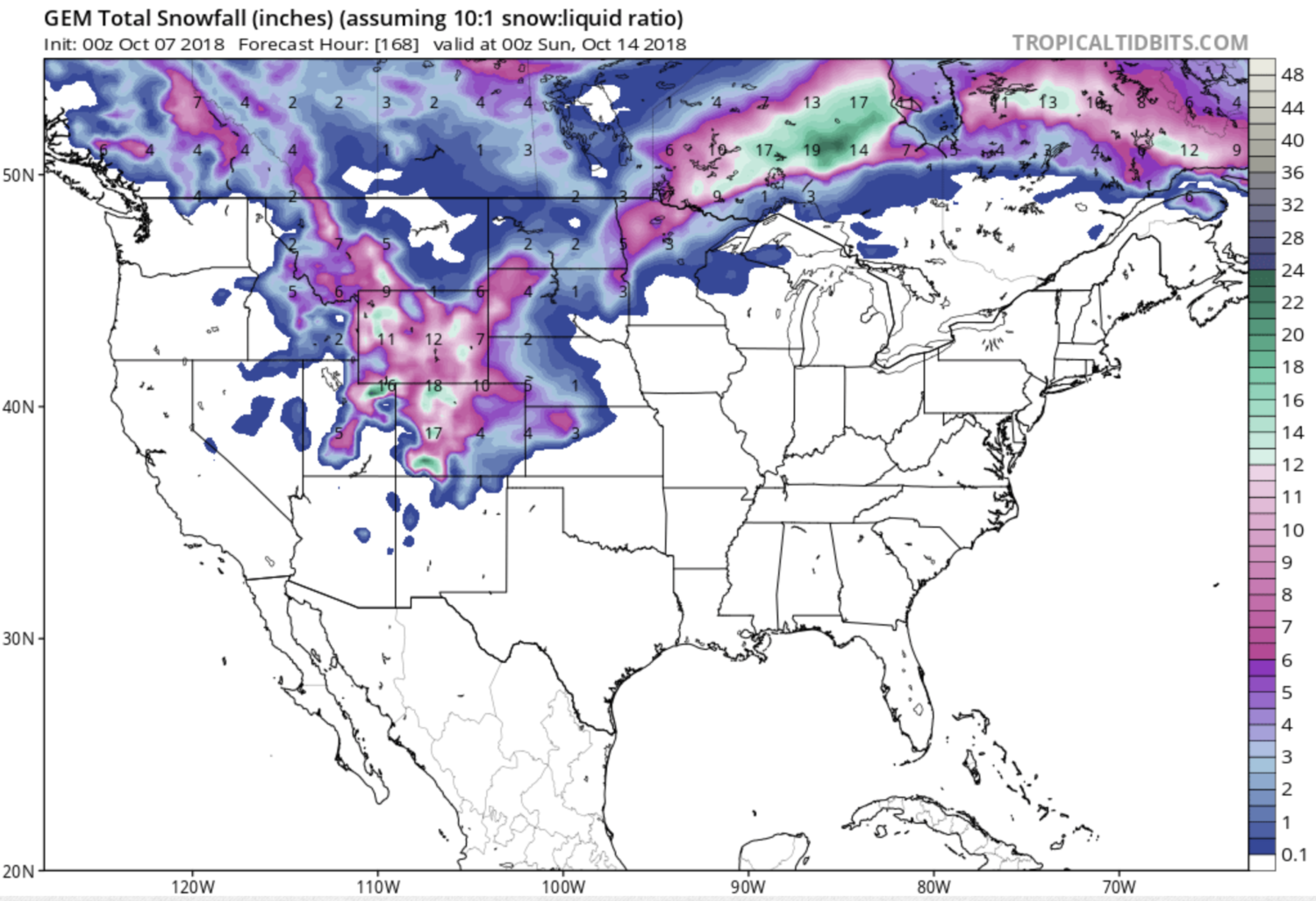
The GEM snowfall model is talking about up to 18″ of snow in northern, central, and southern Colorado in the next 7-days
“This first larger scale snowstorm of the season in the West will put down a blanket of snow across a large area of the mountain West.I think it will be too warm overall for significant snow in high population centers like Salt Lake City and Denver. However there will likely be travel impacts, especially across high terrain like the I-80 corridor through Wyoming. Above is the snowfall forecast through Wednesday. Note those higher snow totals are for locations waaay up, above 8-10 thousand ft. and the snow falls over the course of 2-3 days.” – Tom Niziol, The Weather Channel
7-day snowfall totals looking big in CO… image: tropicaltidbits.com
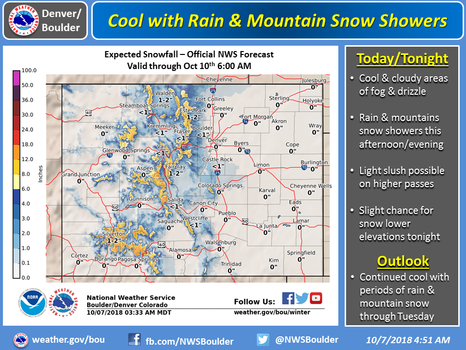
“A strong upper level trough will continue to sit over the Great Basin today, bringing continued widespread precipitation across the area. Rain will occur in the valleys with high elevation snow. Snow levels will start off around 10,000 feet again but will be rising to 12,000 feet this afternoon as warm air still remains in place ahead of this system in response to the south-southwest flow, resulting in wet roads at the passes. With the warmer air in place and warmer road temperatures, conditions at the passes may be more slushy to wet rather than snow-packed. Regardless, ample moisture will keep plenty of showers in the forecast through Tuesday as this system sits over Utah and Arizona through Monday before finally lifting across our region. Colder air will finally move in as this system moves across the area Monday, resulting in snow levels lowering to around 10,000 feet, and down to 8,000 feet by Monday evening into Tuesday. There is still lots of uncertainty with regards to snow levels, the impacts seen and how much snow will actually accumulate at the passes. Temperatures will continue to run below normal overall due to clouds and showers.” – NOAA Grand Junction CO, today
Image: noaa denver co, today
“Rain and snow showers are expected to move across the mountains this afternoon and evening. Snow level may fall below 10000 feet under the stronger showers and produce a quick inch or two of snow. Outside of the stronger showers, the snow level is expected to remain above 10000 feet. Snowfall amounts are expected to be less than 4 inches over the higher areas through tonight. High mountain passes may see a light slushy accumulation on the roads under the stronger showers. In addition, areas of fog are expected over parts of the foothills and plains through tonight.” – NOAA Denver CO, today
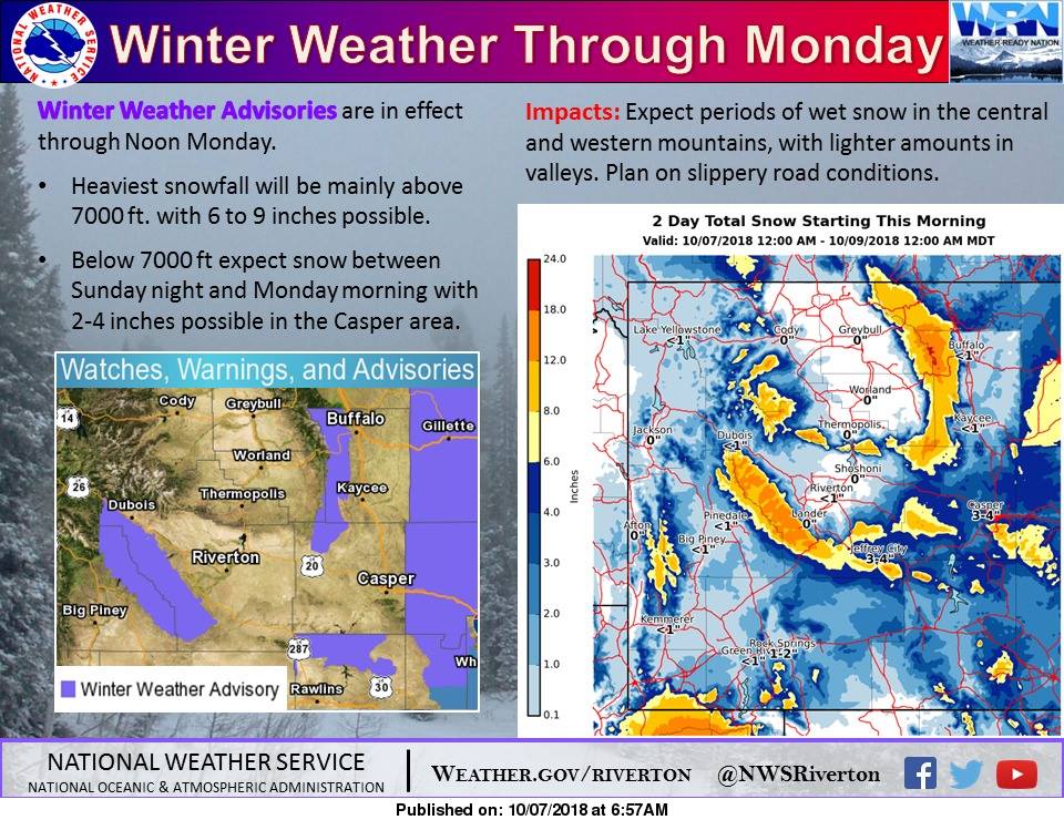
Up to 18″ of snow forecast in WY by Monday. image: noaa riverton wy, today
Winter Storm Warning for Wyoming Today/Tomorrow:
...EARLY SEASON STORM TO BRING WIDESPREAD SNOW TO SOUTHEAST
WYOMING TONIGHT THROUGH LATE MONDAY...
...WINTER STORM WARNING REMAINS IN EFFECT UNTIL MIDNIGHT MDT
MONDAY NIGHT...
* WHAT...Heavy snow expected. Total snow accumulations of 8 to 14
inches, with localized amounts up to 18 inches, are expected.
* WHERE...Snowy Mountain Range. Highest amounts above 9000 feet.
* WHEN...From 6 PM this evening to midnight MDT Monday night.
* ADDITIONAL DETAILS...Expect extremely dangerous or impossible
travel conditions with slick, snow covered roads and very low
visibilities.
- NOAA Riveton WY, today
THE WEST!!!! The only west I know has a coast