This forecast first appeared on AccuWeather
A strengthening El Niño will make this winter different than last year in part of the United States. It will be colder with plenty more snow for millions of people who live in major cities, but that won’t be the case everywhere.
The cold season is upon us, and AccuWeather’s long-range forecasters say El Nino will play a major role in our winter, impacting who could see above-average snowfall.
The upcoming winter is shaping up to be much different than last winter, especially across the central and eastern United States, and AccuWeather forecasters say one month may leave the biggest impression.
“February can be an active and intense month,” AccuWeather Lead Long-Range Meteorologist and veteran forecaster Paul Pastelok said.
One of the driving forces this winter will be the strengthening of El Niño, which will play a significant role in the weather across the United States throughout the entire winter season. The pattern is marked by warmer-than-normal waters in parts of the tropical Pacific Ocean, a counterpart to La Niña, which has ruled for the past three winters.
AccuWeather forecasters explain everything you need to know about the impending cold, snowy weather and what the major pattern shift means for the season ahead in a complete region-by-region breakdown of the 2023-2024 winter forecast.
El Niño to flex its muscles
“El Niño is upon us,” Pastelok said. “It came on strong here in late summer, and it will continue to be strong and a dominating factor going into our winter forecast.”
El Niño is a regular, large-scale climate phenomenon that occurs when the water temperatures near the equator of the central and eastern Pacific Ocean are above the historical average for months at a time. The change in water temperatures reshapes the jet stream and, ultimately, weather patterns in various parts of the world — including North America.
The influence El Niño has on the weather is amplified during the winter months, especially when El Niño is strong, like what is anticipated this winter.
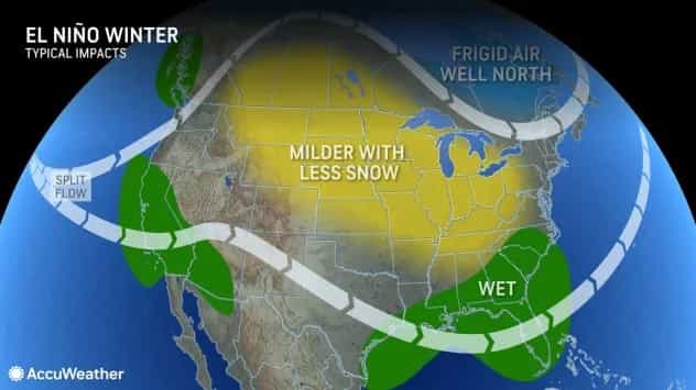
However, Pastelok warns that every El Niño is different and that the weather patterns this winter may vary from recent winters when El Niño was present.
Northeast: Get your snow shovels ready
This winter’s weather in the Northeast is expected to be much different than last winter across most of New England and the mid-Atlantic.
Some of the first snowfall accumulations of the season are typically linked to the effect of lakes when cold air blows over the comparatively warm waters of the Great Lakes to produce snow. Two bursts of prolific lake-effect snow pummeled Buffalo, New York, during the first part of the winter season last year. The first took place in mid-November and unloaded up to 6 feet of snow and was followed by a deadly lake-effect blizzard just days before Christmas.
“We’re not expecting what we saw last year,” Pastelok said. Still, folks who live downwind of the Great Lakes should still prepare for bouts of lake-effect snow from late autumn through the start of 2024.
While Buffalo may not receive as much snow as it did last winter, the millions of people who live along the Interstate 95 corridor are predicted to see more powder than they did during the 2022-2023 season.
The window for snow-producing nor’easters will open in late January through February, which could dish out hefty snowfall amounts to Boston, New York City, Philadelphia, and beyond. “That will be our best opportunity to see some of these big Northeast systems,” Pastelok said.
An early-season nor’easter can’t be ruled out either, as the ingredients for a snowstorm may come together sometime in November.

Last winter, Boston received only 12.4 inches of snow, New York City measured only 2.3 inches, and a snow shovel wasn’t even needed in Philadelphia, where just 0.3 of an inch accumulated throughout the entirety of the winter. Much higher snowfall amounts are predicted this year, with AccuWeather long-range meteorologists forecasting 38-44 inches in Boston, 18-26 inches in New York City and 16-24 inches in Philadelphia — all around the historical average.
The uptick in snowfall will benefit skiers and snowboarders across the region. There may be some lulls in the snow season that could result in short-term setbacks for ski resorts, but a stormy end to the winter will help to prolong the ski season across the Appalachians.
Southeast: Winter to bring uptick in severe weather
A tumultuous weather pattern may unfold over the Southeast this winter, AccuWeather forecasters warn.
“El Niño tends to favor severe weather in Florida and the Gulf Coast states,” Pastelok said.
In addition to El Niño, water temperatures in the Gulf of Mexico continue to run above the historical average. These two factors will create the “perfect setup” for severe weather and tornadoes across the Gulf Coast during the winter, Pastelok explained.
Multiple severe weather outbreaks swept across the region during the first part of 2016 amid a strong El Niño, including a tornado outbreak in Florida on Jan. 17 and a more widespread severe weather event along the Gulf Coast on Feb 23. By the end of February, the number of tornado reports across the U.S. was above the historical average due to severe weather events across the Southeast.
In between the spells of severe weather will be the opportunity for chilly air to make its way as far south as the Gulf of Mexico.
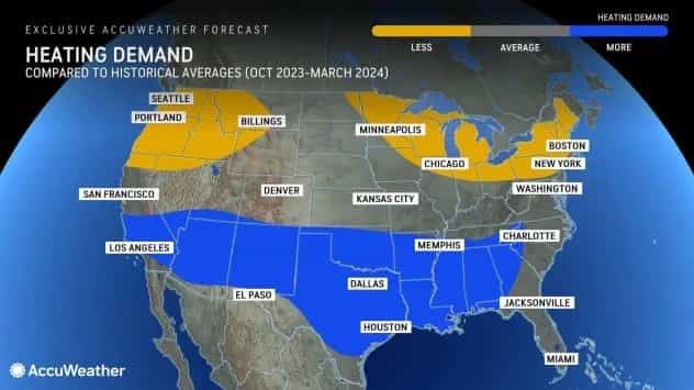
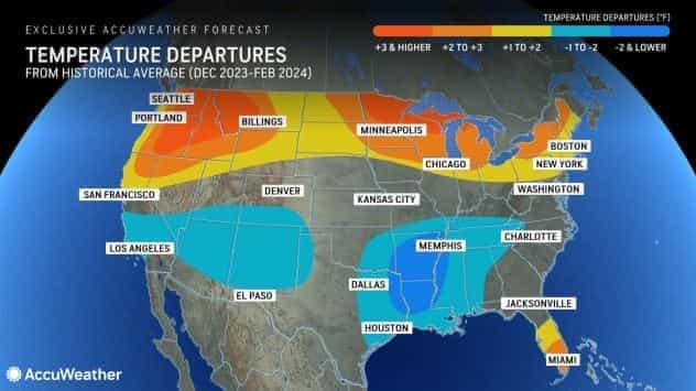
January and February are projected to be much colder across the Southeast when compared to last winter. The result will be a higher heating demand, including in Atlanta, New Orleans, Dallas, and Houston.
The lower temperatures may also be accompanied by the chance of snow and ice across part of the Southeast. Pastelok said that the highest risk for wintry precipitation will be across the Tennessee Valley and the northern extent of the Gulf Coast states. The chance of damaging winter storms will be lower in Texas, but the state could still get one or two storms throughout the season that feature wintry precipitation.
Central US to ride weather rollercoaster
Last winter was one of the snowiest in recent history across the Midwest, a boon for ski resorts across the region as snow frequented the region throughout the season. Minneapolis measured 90.3 inches of snow, the third-snowiest winter in the city since record-keeping began in the 1870s.
This winter is not expected to be a repeat of last year, with the seasonal snowfall totals forecast to be less than half of the totals from last year.
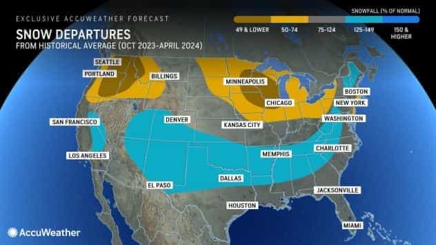
The less frequent snowfall will be accompanied by fewer cold waves, especially during the first part of the winter.
“December should be mild overall across the Midwest and Great Lakes with just a couple of brief, chilly periods,” Pastelok explained. This pattern will carry over into the start of 2024, but the season could take a blustery turn during the second half of winter.
A shift in the polar vortex could open up the gates of the Arctic to unleash frigid air across the central and midwestern U.S. late in the winter, resulting in some of the coldest conditions of the season.
The tumbling temperatures will make energy bills noticeably higher than in the first half of the winter season. Even with the late-season intrusions of Arctic air taken into account, the overall energy demand for the season across the northern Plains and Midwest is predicted to be near to below the historical average.
If the Great Lakes remain primarily ice-free during the first half of the winter, blasts of bitterly cold air later in the winter could trigger some spells of lake-effect snow.
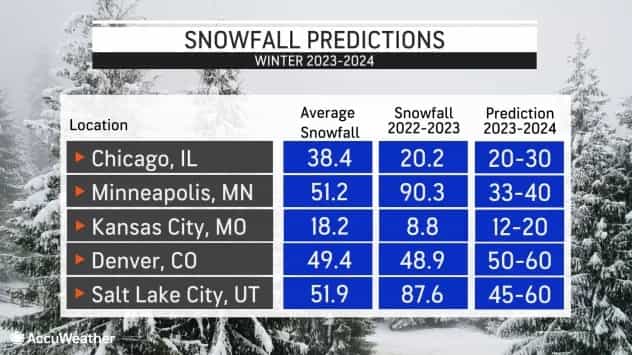
Farther south, snowfall is forecast to be closer to slightly above the long-term historical averages.
Last winter, Kansas City measured only 8.8 inches of snow, less than half of the typical snowfall totals for an entire winter. This year, AccuWeather meteorologists say that between 12 and 20 inches will accumulate in the city.
Seasonal snowfall totals may exceed the historical average in Denver, where 49.4 inches is the historical average for the entire season. AccuWeather is projecting a seasonal accumulation of 50 to 60 inches this winter.
Any precipitation that falls across the central U.S. will help to boost water levels on the Mississippi River, which are near all-time record lows for the second consecutive year. Pastelok said that water levels across the waterway will likely remain low throughout winter before levels return closer to the historical average.
Western US: El Niño to fuel atmospheric rivers
Last winter was one for the history books in California as an onslaught of atmospheric rivers dumped monumental snowfall in the mountains that helped ski resorts remain open until July and flooding rainfall that filled many water reservoirs across the region.
A repeat is possible this winter across California, Nevada, and the Four Corners region, which includes Utah, Arizona, New Mexico, and Colorado, due to the anticipated weather patterns shaped by El Niño. Most El Niños typically result in a stormy pattern over California with frequent rain and mountain snow, while storms largely miss the Pacific Northwest.
The upcoming season does look like it will follow the traditional El Niño pattern, with the jet stream directing storms into California, Nevada, and the Four Corners. This differs from the El Niño of 2015-2016, when storms largely avoided California. Pastelok added that cooler waters southeast of Hawaii could cause the storm track this winter to focus on areas south of Southern California occasionally.
The projected storm track will also send storms over the Four Corners and central and southern Rockies.
Excellent ski conditions are expected in Utah, Arizona, Colorado, and New Mexico for the second year in a row; however, snowfall totals may not reach the benchmarks from last season.
The storm track will help to fill water reservoirs that remain below historical averages due to years of drought, including Lake Mead and Lake Powell.
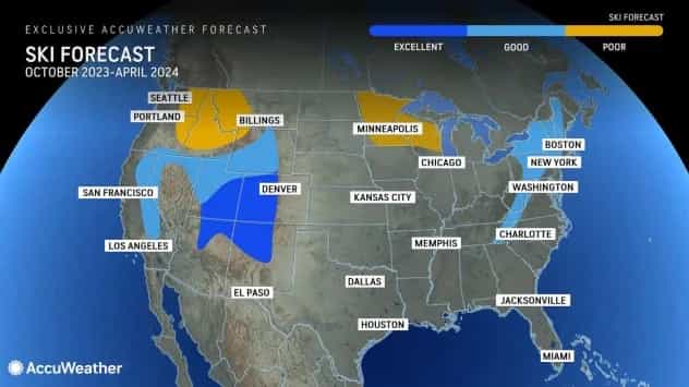
Meanwhile, the predominant storm track is expected to stay south of the Northwest during the heart of the winter season. Some storms may side-swipe areas along and west of Interstate 5 in Washington and Oregon, but the bulk of the rain and mountain snow will miss the Cascades and northern Rockies.
Drought conditions have progressively worsened across Washington and Oregon since the start of the summer, according to the U.S. Drought Monitor. With the most significant winter storms likely missing the region, the drought may expand and worsen through the first part of 2024.
Heating and energy demand
“In the United States, our AccuWeather long-range forecast prediction is for it to be colder this winter than it was last year, with temperatures closer to normal,” AccuWeather Founder & Executive Chairman Dr. Joel N. Myers said. “We expect to see an increase in U.S. demand for heating overall compared to last year, even though many places in the North will still average below historical demand.”
For instance, in New York, heating degree days are predicted to be 4% below the historical average, compared to 15% below last year, which is an 11-12% increase over last year. A similar story will unfold in Boston and the rest of New England.
“The Southern states, including Texas, will also see an increase in percentages of heating degree days (HDD) and perhaps may even exceed historically normal energy demands this year,” Myers said.
