As we’re well into fall now, the NOAA is starting to nail down its forecast for the upcoming winter. These outlooks have been consistently updated every month since last year, but with winter fast approaching, forecasters can start being more specific and accurate. They were updated last week on September 21st, 2023.
- Related: Farmers’ Almanac 2023/24 Winter Forecast: A Return Of Traditional Winter Weather: The Brrr Is Back!
Here’s what next winter might hold for the US:
El Niño conditions are present, as represented in current oceanic and atmospheric observations. A continuation of El Niño is extremely likely this Fall and Winter, with over a 95 percent chance through January-February-March (JFM) 2024. Additionally, a strong El Niño is likely by late Fall and early Winter, with approximately a 70 percent chance of occurrence during the November-December-January (NDJ) 2023-24 season.
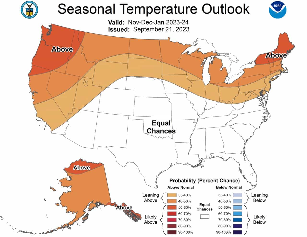
TEMPERATURE
From November-December-January (NDJ) through March-April-May (MAM), impacts from the ongoing El Niño strengthen as above normal temperatures are favored across the northern CONUS and persist across Alaska. EC is indicated across the southern CONUS as El Niño favors cooler than normal conditions for most of the region while recent trends favor warm. A small area of enhanced below normal temperature probabilities are indicated for parts of the Southwest and southern High Plains during JFM and FMA where El Niño composites yield a cold signal and recent trends are relatively weak. After MAM, the forecast pattern increasingly reflects trends with above normal temperatures generally favored across the Northeast during Spring and then expanding across the entire eastern third of the CONUS by the early Summer.
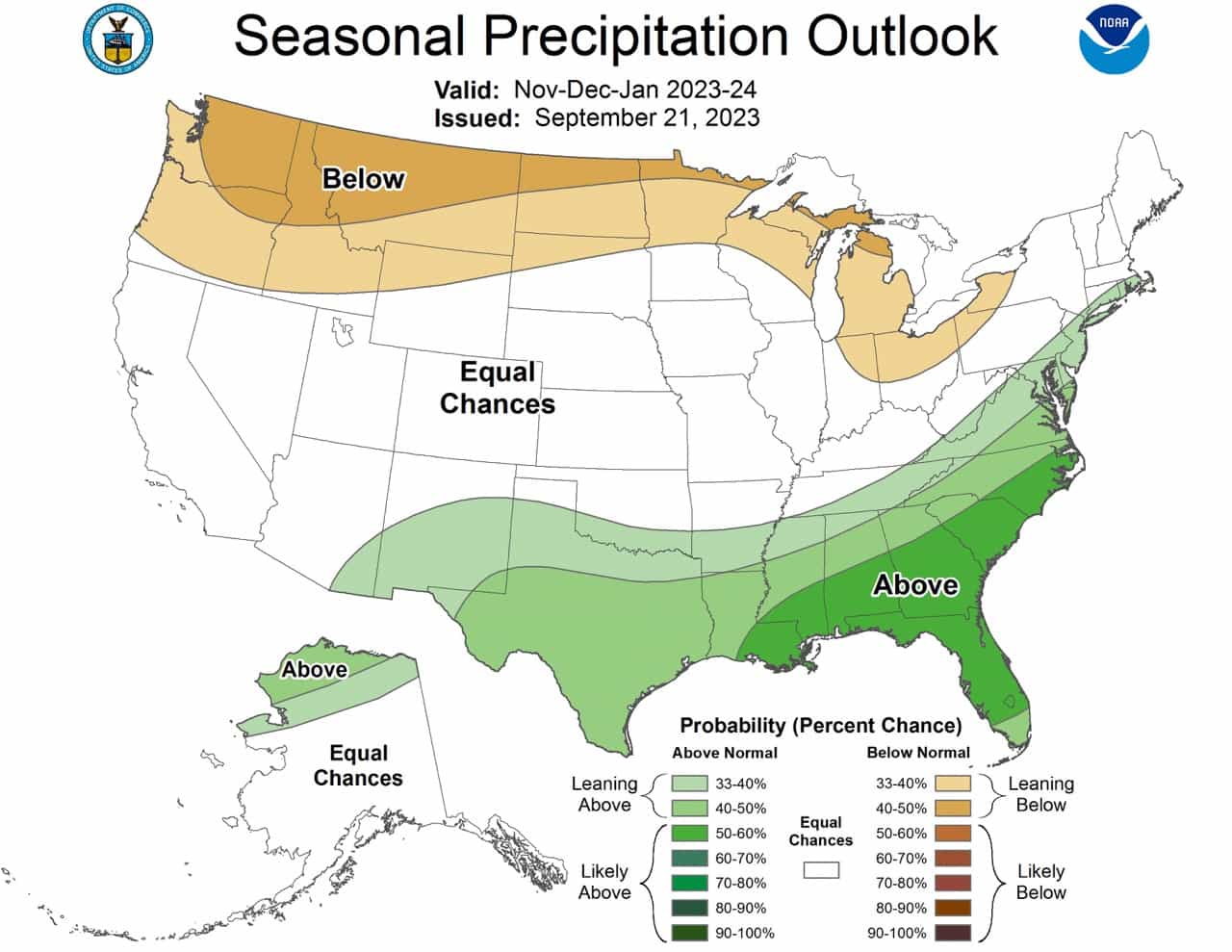
PRECIPITATION
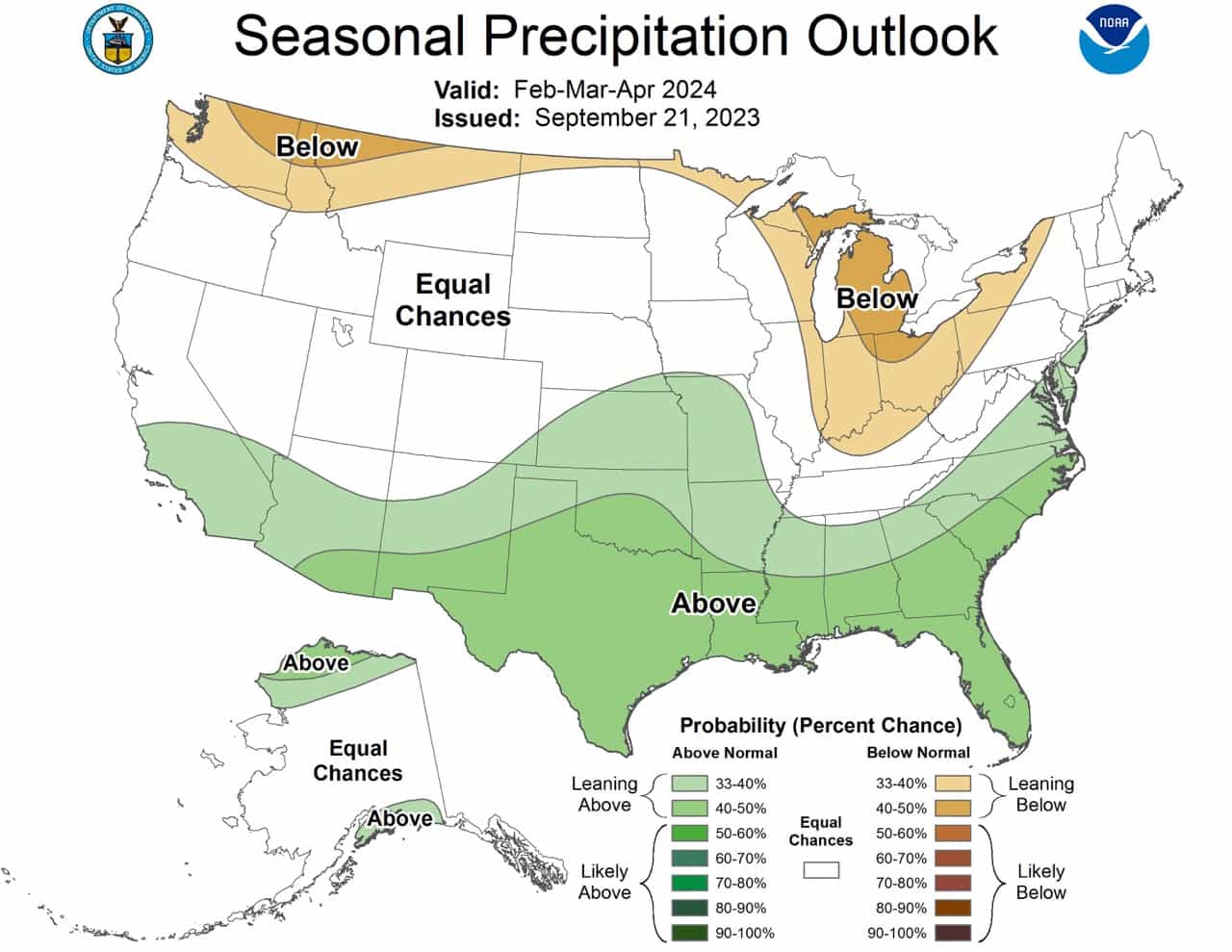
During the winter months, impacts from El Nino are expected to increase, and above normal precipitation is favored for most of the Southern Tier of the CONUS from NDJ to February-March-April (FMA). Additionally, above normal precipitation is favored along much of the Eastern Seaboard during the core of the winter as an East Coast storm track is generally favored during El Niño winters. Conversely, below normal precipitation is more likely across much of the Northern Tier, particularly for the northwestern CONUS and the Great Lakes region. Uncertainty is high across the West Coast as El Niño tends to favor wet along much of the California coast while trends favor dry. Given the increased possibility of a strong El Niño event, a tilt toward above normal precipitation is indicated for Southern California. A tilt toward above normal precipitation is also indicated across the North Slope of Alaska through FMA, consistent with recent trends . Confidence in potential ENSO impacts decreases substantially as we head to next Spring and Summer, resulting in increased uncertainty and coverage of EC across much of the nation. However, during late Winter and early Spring (FMA), guidance from the CFSv2 and other models yields a wet signal across the Southern and Central Plains. The wet signal generally progresses eastward across the Southeast by early Summer (April-May-June (AMJ)) and then to the Mid-Atlantic and Northeast by the middle of the summer (June-July-August (JJA), consistent with trends.
Nov, Dec, Jan
Dec, Jan, Feb


Jan, Feb, Mar


Feb, Mar, Apr

We all know that if the weather is abnormally bad, it is Trump’s fault, and he will be indicted.
These are probabilities & not forecasts. They are basing it on El Niño, but no one knows yet if El Niño will be mild, moderate, strong or very strong. It’s nearly certain it’s not 1982 very strong. Likely not even strong, so that’s great if you like it colder in the East. Mild or moderate tend to cause colder from MN Eastward & to the South into Fla with the wet storms near Gulf Coast & more snows Atlanta to NY up the coast.
CPC is great at getting it right on milder winters, since most have been the last 25 years, but it’s not good at guessing cold ones. The first time I noticed that was 1995-96 when it put probability of mild, then changed it in January after it had been very cold for months. 0
It’s the weather for crying out loud. Can’t you leave politics out of it?
I live for these kind of predictions, but I gotta ask, does anyone track how well these forecasts pan out? Like, how well did NOAA do in predicting last year’s warm and wet eastern winter and western snow?
Why not he’s.guilty of everything else.He’s a criminal. Just waiting for those cuffs!!!!!
Well we all know if the weather IS below normal it is Trumps fault and he will be indited criminally for it
Some who isnt a weather geek, how do you read these maps ????
It’s going to snow Washington REDSKINS all winter
You guys NEVER get our weather forecast even near right. I live in N. Central NC just below the Va. state line. The weather here is a “crap shoot” all year !!!! Just my opinion. I am an amateur meteorologist and you guys just dont seem to know what you are doing….lol. I foresee a much colder than normal winter ( strong El Nino ) with a back to “normal” snow forecast for this area
( 10 in or more for the season ). C’mon get with it….better to be wrong about cold and snow than to just say it ain’t happening !!!!!! I DO believe in climate change…it’s just NOT MAN MADE !!!
Let’s see whose right on ’23-’24, shall we ?
mfbigray@yahoo.com
didnt expect to see any below normal temps considering this agency is a Biden mouth piece