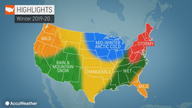
We’ve had the Farmer’s Almanac, and the Old Farmer’s Almanac both give us their winter predictions. The NOAA has had their say, and every local meteorologist in every state has chimed in with their opinion too. So now it’s the turn of AccuWeather. Here is their annual winter forecast for the lower 48. As 2019 comes to a close, AccuWeather’s long-range forecast team predicts an active winter season will get underway for the northeastern United States. The Southeast, however, is more likely to be targeted by rain than wintry weather.
Meanwhile, ample snowfall during winter in California will help stave off drought conditions come springtime. And will Arctic air surging down from a disturbance in the polar vortex make a return this winter?
Take a look below at a complete region-by-region breakdown.
Southwest and California
A cool, unsettled pattern is in store for the Southwest and California this season.
“At times, these areas could also have back-and-forth conditions, between some periods of dry weather and some active weather in the early winter, which is not really typical,” AccuWeather Expert Long-Range Forecaster Paul Pastelok said.
In California, the winter will yield enough precipitation to stave off drought conditions into the spring.
“I think they will get ample snowfall, just enough that will fill those reservoirs up in the spring and early summer. It’s the late summer, of course, that becomes more critical,” Pastelok said.
A normal season in terms of snowfall will also translate to decent ski conditions for resorts in California.
North/Central Plains and Midwest
Last January the polar vortex unleashed a record cold snap across much of the US, but at least for the first part of winter, the polar vortex isn’t expected to make a debut, according to Pastelok. While Pastelok cautioned that predicting exactly how the polar vortex will behave several months out is difficult to do, he stated that it could still be a key player in part of the winter.
“The polar vortex is particularly strong this year, and that means that frigid air is likely to remain locked up over the polar region early in winter,” Pastelok said. Instead, cold air that could reach the Midwest at times early in the season is likely to originate from a Siberian Connection, rather than straight from the North Pole, and that has implications on just how cold it will get.
However, conditions may change and allow the polar vortex and accompanying Arctic air to bust loose later during the winter, he said. With such a pattern expected this winter, milder-than-normal weather will kick off the season in December across the northern and central Plains states. But it won’t last for long. Arctic air is expected to surge into the region at points during the season, although it’s too soon to tell exactly where the coldest conditions will take hold. Pastelok predicts near- to below-normal snowfall across the northern Plains, with near- to above-normal totals in the central Plains.
Further east, in the Upper Midwest and Great Lakes, cold air will encourage a number of lake-effect snow events. Residents will want to stock up on shovels, as an above-normal season for snowfall is in the offing.
Northwest
In the Northwest, wintry weather will be more scarce than usual. Strong high pressure over the region is likely to lead to drier conditions and above-normal temperatures.
“I can see some places this winter in the Northwest being about 20 to 40 percent lower on the snowfall compared to average,” he said.
The deficit is likely to hinder the region’s ski season and will continue to affect the weather into springtime.
“For those who rely on hydropower: If water levels are down, it could have an effect on cost.”
Northeast
Despite a few cold spells across the Northeast during autumn, winter’s chill won’t arrive until at least the end of 2019. AccuWeather Expert Long-Range Forecaster Paul Pastelok said,
“I think you’re going to see a touch of winter come in in December. But I think its full force will hold out until after the new year.”
Once the wintry weather does get underway, an active season will be in store.
“Whether or not it’s snowstorms, ice storms or mixed events, I do feel this is going to be an active year for the Northeast,” he said.
Above-normal snowfall could be in store for areas from New York City to Boston. Meanwhile, cities farther south, including Washington, D.C., and Baltimore, will be more likely to get a mix of rain and snow.
Southern Plains
The southern Plains will experience a “back-and-forth” weather pattern for much of the winter. Pastelok said, “When we say ‘back and forth,’ we’re talking about extremes.”
“In January, you may get a couple of chilly air masses, but it’s offset by December and February when the temperatures actually end up being above normal,” he said.
Early on, the region may get a few wintry events with snow and ice before milder air returns.
“The cold air will be lacking from time to time,” Pastelok said. “The best chance of getting any significant chill is probably in January for Dallas and Oklahoma City.”
Southeast
While the Northeast braces for snow and cold, the Southeast is more likely to experience a wet couple of months. Water temperatures from the Gulf of Mexico to the Southeast and mid-Atlantic coasts are running higher than normal, Pastelok said. As storms move into the east early on in the season, the warm water could generate a significant amount of rain.
However, it’s not out of the question that the region could experience a winter storm, similar to last season, which brings snow or ice to areas like Winston-Salem, Charlotte or Asheville.