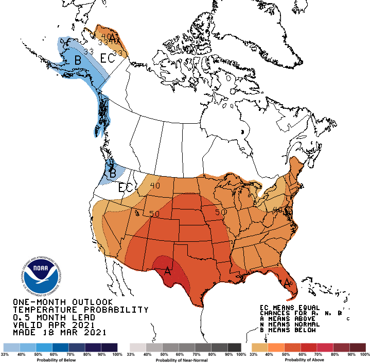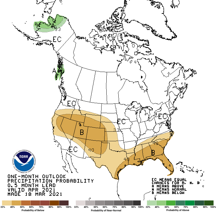
The NOAA has just released its outlook for April 2021. With the exception of the PNW, it’s looking warmer and drier than normal for the majority of the country. Time to top up those goggle tans!
- Related: NOAA Mar-Apr-May Outlook: Above Normal Temps and Lower Than Normal Precipitation For Most of CONUS
The full discussion below:
The April 2021 temperature outlook favors above-normal monthly mean temperatures for nearly all of the CONUS, with the exception of the Pacific Northwest, eastward into parts of the northern Intermountain West, and southward along much of the immediate coastline of California. This outlook is supported largely by dynamical model forecast guidance, from the models of the NMME and IMME, which are in very good agreement over much of the CONUS. Decadal temperature trends contribute to higher probabilities for above-normal temperatures across the southern tier of the CONUS and into the Northeast region. A soil moisture deficit across much of the western CONUS may contribute to increased probabilities of above-normal temperatures in some regions of the West, particularly the Southwest, where model guidance leads to probabilities exceeding 60 percent in some areas of southeastern New Mexico and western Texas. A much larger area of probabilities for above-normal temperatures exceeding 50 percent over the West is supported by the consensus forecast of the NMME. Typical temperatures observed during April under La Nina conditions were considered, and support increased chances of below-normal temperatures over parts of the Pacific Northwest. Dynamical model guidance, as well as persistent impacts of La Nina, favor increased probabilities for below-normal temperatures across southern Mainland Alaska into the Alaska Panhandle, while decadal temperature trends are the primary forcing leading to likely above-normal temperatures across northwestern coastal areas of Mainland Alaska and the North Slope.
For precipitation, consistent dynamical model forecast guidance from models of the NMME and typical La Nina impacts in spring favor below-normal precipitation stretching from California and southern Oregon eastward across the Central and Southern Rockies into the Central and Southern Plains, the Lower Mississippi Valley, and much of the Southeast region. Increased precipitation variability and decreased predictability in dynamical model forecasts leads to a lower probability for below-normal precipitation for some areas of the Southern Plains. Equal Chances (EC) of above, near and below-normal precipitation are indicated for remaining areas of the CONUS, including drier areas of the Southwest. Inconsistency between the typical above-normal precipitation signal due to La Nina and dynamical model forecasts of below-normal precipitation for parts of the eastern Central Plains leads to a forecast of EC for this area in the April outlook.
The consensus of dynamical model forecast guidance favors above-normal monthly total precipitation amounts for parts of the southern Alaska Panhandle, supported by typical impacts of La Nina conditions. La Nina conditions support above-normal precipitation for western Mainland Alaska, as does the consensus of dynamical model guidance. EC is forecast for remaining areas of Alaska, where climate signals are weak and dynamical model forecasts are inconsistent.
