This article was originally published on climate.gov
La Niña continues! It’s likely that the La Niña three-peat will happen: the chance that the current La Niña will last through early winter is over 70%. If it happens, this will be only the third time with three La Niña winters in a row in our 73-year record. ENSO (El Niño/Southern Oscillation, the whole La Niña and El Niño system) has the greatest influence on weather and climate during the Northern Hemisphere cold season, so forecasters pay especially close attention when it looks like ENSO will be active in the winter.
Hopelessly Devoted to You
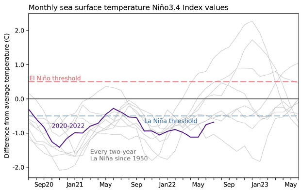
La Niña is present when the sea surface temperature in the east-central Pacific Ocean is at least 0.5 °C (0.9 °F) cooler than the long-term average, along with evidence of a stronger atmospheric circulation above the equatorial Pacific. In July, the sea surface temperature in the Niño-3.4 region of the tropical Pacific, our primary monitoring region, was 0.7 °C cooler than average (average = 1991–2020) according to the ERSSTv5 dataset. This makes 21 of the past 24 months with a deviation from average below -0.5 °C.
We Go Together
The average circulation of the atmosphere over the tropical Pacific—called the Walker circulation—makes a giant loop: rain and rising air over the very warm waters of the far western Pacific and Indonesia, west-to-east winds at high altitudes, descending air and drier conditions over the relatively cooler central/eastern Pacific, and the east-to-west trade winds near the surface. La Niña’s cooler-than-average central/eastern Pacific acts to strengthen this circulation, with more rain than average over Indonesia, less rain over the central tropical Pacific, and stronger upper-level and lower-level winds. In turn, those stronger low-level trade winds cool the surface further, and help to keep warm water piled up in the far western Pacific.
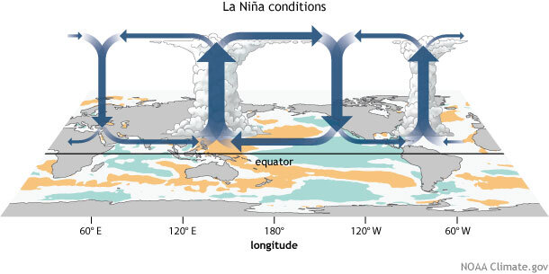
July recorded all the expected strengthened Walker circulation features, including substantially stronger-than-average trade winds. The trade winds led to the cooler-than-average surface temperature strengthening over the month, a tendency we can see in the weekly measurements, which started July at -0.5 °C and ended at -1.0 °C. While the weekly anomaly is useful for monitoring current conditions, ENSO is a seasonal phenomenon, so conditions must remain for several months to qualify, and to affect global weather patterns. Michelle gets into this in more detail in her internet-ancient—but still entirely relevant—post.
Rock ‘n Roll Is Here to Stay
Another outcome of the stronger trade winds during July was the development of an upwelling Kelvin wave, cooler-than-average water that travels west-to-east under the surface of the equatorial Pacific. As the trade winds drag the surface waters westward, cooler water is drawn up from the deeper ocean.
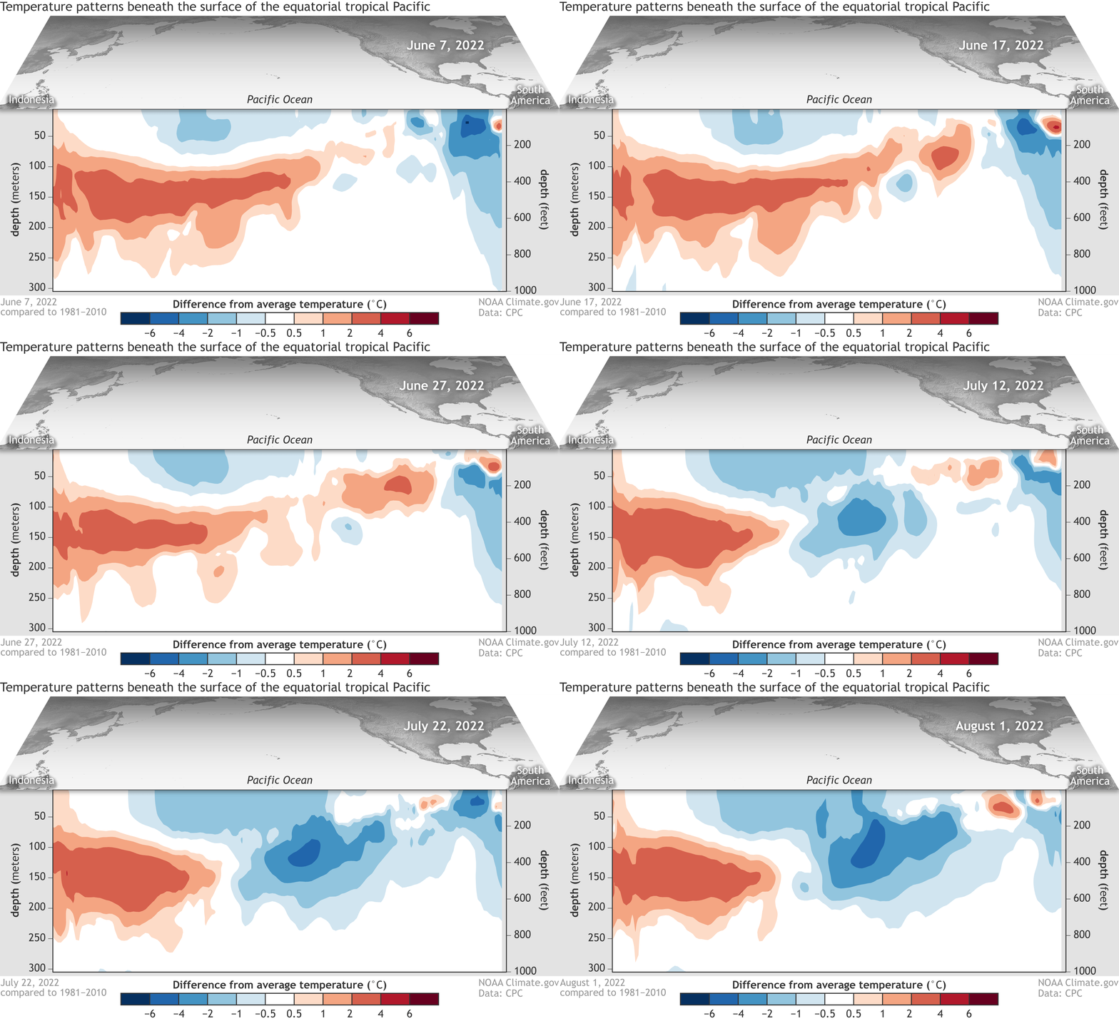
This upwelling Kelvin wave will provide a source of cooler water to the surface over the next couple of months, which in turn provides increased confidence to the short-term La Niña forecast. With most of our computer models predicting La Niña will last into the winter, forecaster probabilities are fairly confident through December–February.
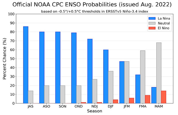
Several models are predicting that La Niña will transition to neutral in January–March, and the forecast team provides even chances (47%) for either outcome (La Niña or neutral). It would be pretty rare for the event to terminate so early in the year. If La Niña does decay to neutral in January–March 2023, it would be only the 4th time in the 24 La Niña winters we have on record.
Greased Lightning
As I mentioned up above, La Niña’s greatest influence on weather and climate is during the winter. Also, of course, La Niña can be conducive to an active Atlantic hurricane season, something reflected in NOAA’s recent update to the outlook.
During summer, local processes are more important for determining weather patterns, including the North American Monsoon. This year, the Monsoon has contributed to some devastating floods, but also provided much-needed rain for the drought-stricken Southwest. I checked in with our consultants for the North American Monsoon post, Zack Guido and Mike Crimmins. They have an excellent podcast with tons of fascinating detail about the Monsoon, so check it out if your interest is piqued!
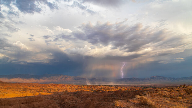
Mike had this to say about this year’s Monsoon:
We just crossed through the typical middle of the season (early August), and the first half was really good for just about all of the Southwest. Over 80% of Arizona and New Mexico are observing near-average or better rainfall so far this season, and more than half of the region at above-average or better! The whole season started with some epic rains over New Mexico that helped end their record fire season, and the moisture and storms have kept coming ever since.
This year has been interesting and different from last year’s very wet monsoon. Last year we had great monsoon moisture and two unusual large upper-level low pressure systems bring several days of widespread rain in July and August of last year. We haven’t really had anything big like that this year, just sustained deep moisture and the occasional wiggle in the upper-level flow to help organize precipitation into lines of storms from time to time. It has felt a bit more like a solid, active season that hasn’t needed any special tricks to stack up the precipitation totals across the region.
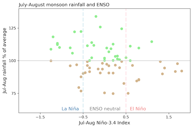
The relationship between La Niña and the Monsoon is not strong , but I asked Mike if he could speculate a little. He had this to say:
I am not sure of the influence of La Niña this year, but it certainly could be there. Some research on ENSO and the monsoon suggest that La Nña is correlated with an early start to the season in Arizona and New Mexico and wetter-than-average conditions through July. The signal then decays through August. This season follows that pattern, but I’m not sure of the causal links.
You’re the One That I Want
The Monsoon has helped with the Southwest drought, something Tom discusses in his recent coverage of the August climate outlook. However, La Niña often contributes to dry winters through the West, so we’re far from out of the woods, drought-wise. Stay tuned here—we’ll keep you up to date on all things ENSO.