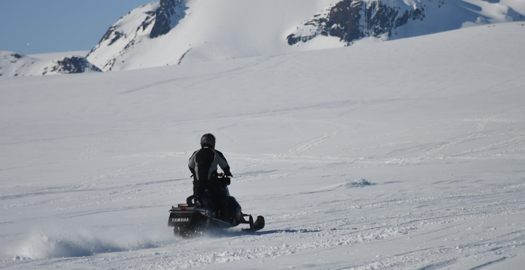
A snowmobiler was killed in an avalanche in Squaw Creek area in Lincoln County, WY, on February 17th, 2021. A group of eight snowmobilers triggered and were caught in the avalanche in the area up Greys River Road at around 1:30 pm.
One of the group, a 55-year-old man, was buried for 20-minutes before he was dug out. Attempts to revive him with CPR were unsuccessful.
The avalanche forecast was ‘considerable’ for the area at that time.
Below is the full report from Bridger-Teton Avalanche Center.
Avalanche Comments
Squaw Creek Avalanche Accident
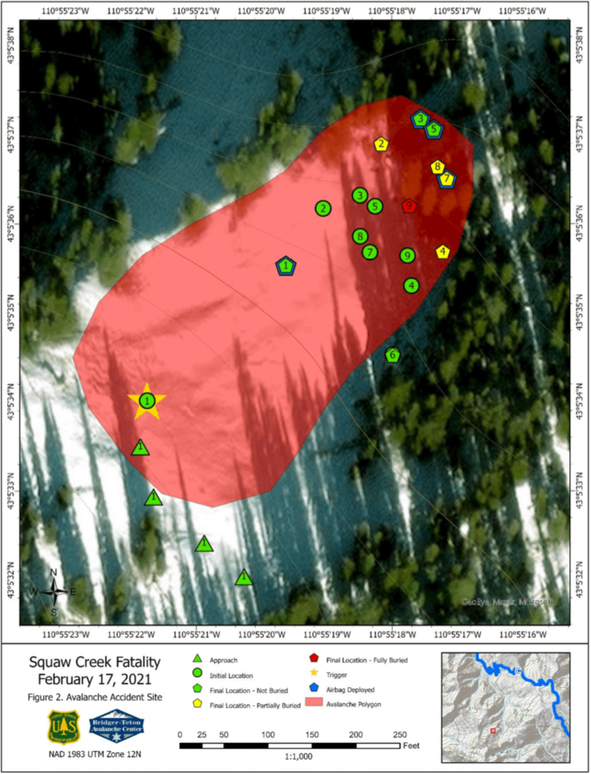
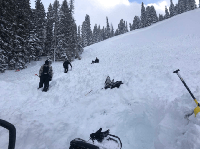
On February 17, 2021, a group of nine snowmobilers were riding in the Squaw Creek Drainage southeast of Alpine, Wyoming in the Salt River Range. The group was experienced and familiar with this terrain and the current avalanche hazards. When the accident occurred one rider (rider 1) rode onto a steep slope from above. He triggered a 2 to 3-foot-deep soft slab avalanche that caught seven other members of the party. That rider rode his sled down the slope into the run-out zone. He was not buried in the avalanche debris and immediately began to rescue other members of the party who had been caught. His sled was partially buried.
Rider 1 uncovered Rider 2 who was buried in the avalanche debris with just his face showing. Riders 1 & 2 and other members of the group (Riders 3,4,5 & 6) that were not buried or only minimally buried, uncovered the heads of Riders 7 and 8 who were buried and pinned under their running sleds with only their helmets showing above the avalanche debris. The group quickly established that all members of the party were accounted for except one person (Rider 9) who was completely buried.
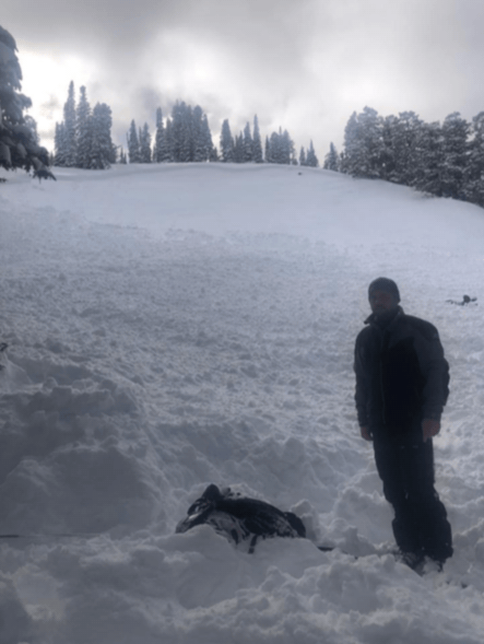
A transceiver search was conducted by some, as other members of the group further excavated Riders 7 & 8 for the purpose of gaining access to their transceivers and turning them off. The searchers homed in on Rider 9’s signal and confirmed his location with a probe strike. Strategic shoveling techniques were used to excavate Rider 9. He was found to be face-up, head downhill beneath 4 to 5 feet of avalanche debris. He had an airbag but did not deploy it. He and his sled had been swept into a treed area at the base of the slope. His sled was damaged by impacts to the trees and he had signs of trauma. CPR was administered but he did not survive.
All members of the group were wearing airbags. Four of them were deployed. They included the rider who was not caught in the slide (Rider 6) and Riders 1, 3, and 7. This slide was reported to have been a soft slab avalanche that was 2 to 3 feet deep. It is estimated to have been 285 feet wide and ran 580 feet down the slope. It occurred on a northeast aspect at an elevation of 8,300. The vertical drop of this slide is estimated to have been 250 feet. It produced avalanche debris that was up to ten feet deep and ran into a treed area at the base of the slope (SS-AMu -R2-D2).
Backcountry Avalanche Forecast
On February 17 the avalanche danger scale rating for the Southwest Trails/Greys River forecast area was Considerable (Level 3) at all elevations. That morning’s avalanche advisory listed persistent slabs and wind slabs as potential avalanche type problems. The wind slab problem was delineated on aspect/elevation diagrams on all aspects above an elevation of 9,000 feet and on all but west aspects at elevations from 7,500 to 9,000 feet. There was a possible likelihood of triggering a small to large wind slab avalanche in that delineated terrain. The potential to trigger a large to very large persistent slab avalanche was likely on all aspects above an elevation of 7,500 feet and on west through north to southeast aspects below that elevation. This accident occurred on a northeast aspect at an elevation of 8,300 feet. The general avalanche advisory read:
Avalanche conditions are dangerous. New snow continues to increase the load on persistent weak layers that formed earlier in the season. Humans who venture onto steep avalanche-prone slopes are likely to trigger large to very large slab avalanches. These dangerous slides are likely to be un-survivable. Expert snowpack and terrain analysis skills are essential for safe travel in avalanche terrain today.
The wind slab avalanche problem description read:
In steep terrain above 7,500 feet west to southwest to northwest winds have formed wind slabs on leeward aspects. These slabs could be human-triggered. They are likely to be 1 to 3 feet deep. These surface slabs could step down to weak layers deeper in the snowpack and become a large to very large persistent slab avalanche.
The persistent slab avalanche problem description read:
Large to very large slab avalanches could be easily triggered by a person on a variety of aspects. These slabs could be three to six feet deep.
Weather Summary
The Bridger-Teton Avalanche Center operates five specialized, remote weather stations in the Greys River area. Three of these are used to monitor weather conditions in this area. A wind station on one of the summits of Deadman Mountain at an elevation of 10,300 feet is located 14 miles southeast of the accident site. Precipitation stations are located at an elevation of 9,000 feet on Blind Bull Summit and at an elevation of 6,500 feet at the Box Y Lodge. These stations are located 18 and 16 miles southeast of the accident site, respectively.
Skies were partly to mostly cloudy on February 17. Cloud cover was more extensive over the higher terrain which experienced off and on snow showers and brief breaks in the cloud cover. Temperatures at all three of our remote stations were in the single digits in the morning hours and fell back into the single digits by sunset. Afternoon highs peaked in the mid-teens around 3 pm at the Deadman Mountain station (10,300 feet) and at the Blind Bull station (9,000) feet. Afternoon temperatures rose into the ’20s at the Box Y Lodge (6,500) feet. Both of the snowfall stations received 0.02 inches of moisture during the day on February 17. Winds were from the northwest at around 20 miles per hour with higher gusts during the 24 hours before the accident occurred.
Snowpack Summary
Wind, air temperatures, and snowfall data from the three remote weather stations operated by the Bridge-Teton Avalanche Center are monitored daily from early October through May. That data and field observations are used to monitor the development of the structure of the snowpack in this area.
The period from January 27 to February 17 was unusually snowy. Conditions were mostly cloudy with some new snow nearly every day. New snow totals during this period were 77 inches at both the Blind Bull and Box Y Lodge stations. There was a brief break in this storm cycle on February 8 & 9. This area received 2 to 3 feet of snow after that break and 3.5 to 4.5 feet of snow from January 27 to the February 8 break in the storm cycle.
This accident involved a soft surface slab avalanche that was 2 to 3 feet deep. The storm cycle continued in this area until February 23. Due to overhanging hazards in this area, this accident site was not visited.
Events Leading to the Avalanche
This group was comprised of riders who live in Wisconsin and Michigan. Members of the group have been riding in the mountains of the western United States since the late 1990s and in the Alpine area since 2012. All nine had some avalanche classroom training and two had field training. They arrived in Alpine on February 13 and had been riding in this area for 3 days before the accident occurred. They were aware of the current avalanche hazard and reviewed the local avalanche hazard bulletin every day. They talked about the details of the hazard and did beacon checks at the trailhead every day.
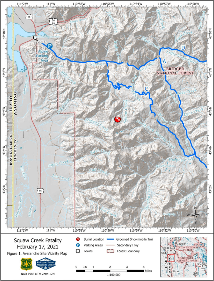
The accident site is located 7 miles southeast of Alpine, WY. The group rode in the vicinity of the accident site during the morning hours on February 17. Riders 1 & 2 went to the slope where the accident was to occur and rode up and down it about a dozen times and side-hilled across it while the other riders were playing in nearby terrain. Rider 1 got stuck in the upper portion of the accident slope. Rider 2 stopped and helped Rider 1 get unstuck. Rider 2 felt the slope settle while he was helping Rider 1 get unstuck. After Rider 1 was able to ride again they went and got the other riders and brought them to the slope. They reported that this slope was not steep except for the very top portion of the slope. When the slope did fail the riders involved were surprised at how far the slide propagated across the slope.
Rescue Summary
The group performed its own rescue. After all members of the group were accounted for a call for organized help was made with a cell phone. At this time the one rider who was fully buried had been uncovered. It was determined that he was unresponsive, not breathing, and did not have a pulse. CPR was conducted for 45 minutes. The party estimated that he had been buried for about 8 to 10 minutes. The cause of death was determined to be asphyxia by the Lincoln County Coroner.
Cell phone coverage was spotty. The Lincoln Co. Search & Rescue (LCSAR) volunteers received notification of this accident at 15:46. At 16:48 Teton County Search & Rescue volunteers were contacted and requested to respond to the scene with a helicopter. That helicopter and a short-haul rescue team arrived at the site at 17:48. That crew removed rider 9’s body from the accident site. Members of the LCSAR arrived at the accident site via snowmobile and escorted the remaining members of the party to Alpine.
Comments
All of the fatal accidents that we investigate are tragic events. We do our best to describe each one to help the people involved and the community to better understand them. We offer these comments in the hope that they will help people to avoid future avalanche accidents.
Eight out of nine members of a group were caught by an avalanche on a slope that had previously been tracked by two members of the group. The group had rescue gear and conducted their own rescue. One rider, who was fully buried, did not survive.
Avalanche Details
- Location: Squaw Creek Drainage, Salt River Range
- State: Wyoming
- Date: 2/17/2021
- Time: 1:30 PM
- Summary Description: 8 Snowmobilers Caught
- Primary Activity: Snowmobiling
- Primary Travel Mode: Snowmobile
- Location Setting: Backcountry
Number
- Caught: 8
- Partially Buried, Non-Critical: 7
- Partially Buried, Critical: 0
- Fully Buried: 1
- Injured: 0
- Killed: 1
Avalanche
- Type: SS
- Trigger: AM – Snowmachine
- Subcode: u (unintentional)
- Size – Relative to Path: R2
- Size – Destructive Force: D2
- Sliding Surface:
Site
- Slope Aspect: Northeast
- Site Elevation: 8,300 feet
- Slope Angle: 37 Degrees (estimated)
- Slope Characteristic: Steep Hillside
List of Attachments:
- Figure 1 – Accident Site Vicinity Map
- Figure 2 – Accident Site Map
- Figure 3 – Site Photograph
- Figure 4 – Site Photograph
- Figure 5 – Site Photograph
Information was provided by Lincoln and Teton County Search & Rescue volunteers and members of the group involved. This report was produced by Bob Comey and Chris McCollister from the Bridger-Teton Avalanche Center.