This post is taken from The Farmers’ Almanac and was written by Caleb Weatherbee
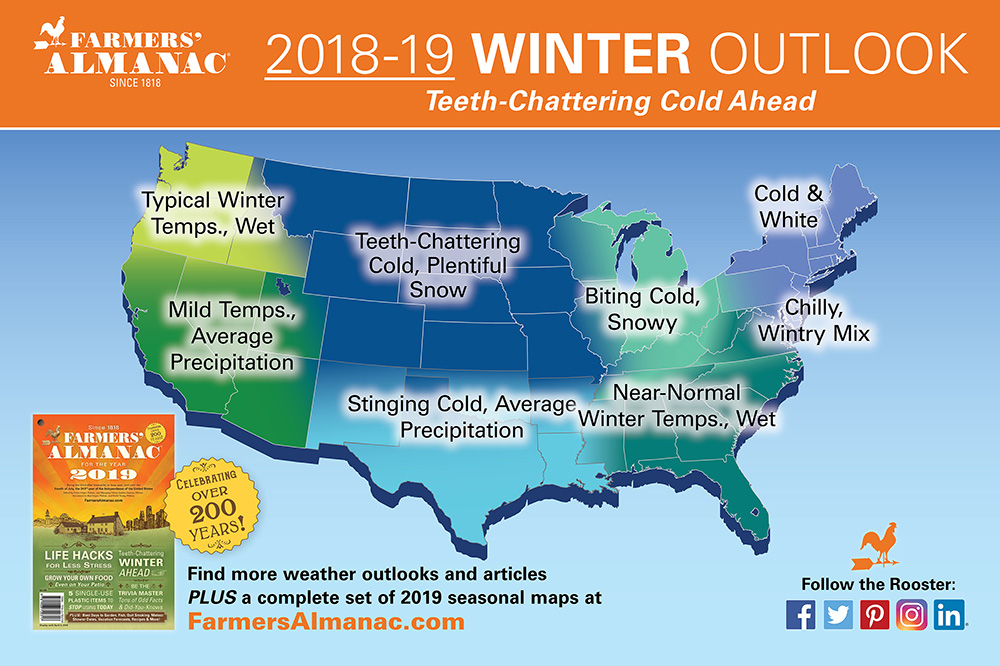
Every year, right before we launch our newest weather forecast for the winter, we like to take a look back at last year. Our winter prediction for 2018-19 brought about a lot of attention and controversy. In our long-range outlook, which we released in August 2018, we called for “teeth-chattering cold and unusually snowy and/or wet conditions across the Pacific Northwest, Northeast, and Mid-Atlantic States.” We forewarned that the coldest temperatures would arrive in February and predicted a stormier-than-normal March, which would push snow totals to above normal for the northern/central Rockies and Plains.
Here’s last year’s forecast: Farmers’ Almanac 2018/19 Winter Outlook:

So what happened? Here are some winter 2018-19 highlights:
- A late January Arctic blast resulted in Chicago having subzero temperatures for 52 straight hours. No all-time records were broken in the Windy City, but the low temperature of -23°F was close to breaking the all-time record of -27°F. On January 29th, Chicago’s wind chill dipped to -52°F! That’s some teeth-chattering cold!
- On January 31st, 2019, the all-time coldest record for Illinois was reported in Mt. Carroll at -38°F.
- February kicked off on a frigid note from Minnesota and Wisconsin east through the Great Lakes into upstate New York and across to New England. High temperatures were as much as 30°F colder than normal, and low temperatures were subzero or in the single digits for most areas. Strong winds created dangerously low wind chills, causing some schools to close.
- For the first time on record, Los Angeles went an entire February without once hitting 70°F. And the City of Angels registered this past February as its coldest month since 1962, with temperatures averaging about 5 degrees colder than normal.
- And the month of February across the contiguous U.S. averaged nearly 2°F below normal, ranking it in the coldest top third in 125 years of record keeping.
Snowfall?
- Caribou, Maine, had its snowiest January ever, with 59.8 inches, and 165 had its snowiest January ever, with 59.8 inches, and 165 inches total for the winter months!
- Record snowfall and cold temperatures were reported from Washington State to Wisconsin in February. Eau
- Claire, Wisconsin, set a record for all-time snowiest month with 53.7 inches.
- Sea-Tac Airport (Seattle) saw its snowiest February (20.2 inches) since record-keeping first began in 1945.
- On February 20th, the first measurable snowfall (½ inch) in more than a decade fell in Las Vegas, Nevada. And the very next day, a total of 35.9 inches of snow was measured at Pulliam Airport (just south of Flagstaff, Arizona)—a new 1-day record.
- Omaha, Nebraska, saw its all-time snowiest winter with 46.1 inches.
Statistically Speaking
Sounds like a pretty accurate forecast, doesn’t it? You may be surprised to learn that climatologists have indicated that winter 2018-19 turned out to be slightly warmer(1.2°F) than normal, statistically speaking.
The reason? Taking into account the 90-day interval from December 1st to February 28th (defined as “meteorological winter”), the mean temperature was 33.4°F or 1.2°F above average. Yet, the last week of January through February, and into early March, temperatures averaged more than 2°F below normal nationwide. But overall, January was 2.6°F above normal, and December was 2.9°F above normal.
However, we would contend that the overall 1.2°F above-normal winter temperature was of little solace to the folks in the southeast U.S. who were digging out of their big pre-Christmas snowfall, or the folks around the Great Lakes and Plains who were enduring hours of subzero temperatures and life-threatening wind chills in late January!

What’s in Store for Winter 2019-20?
We release our extended forecast next week, so be sure to keep your eyes on our home page so you don’t miss a thing!