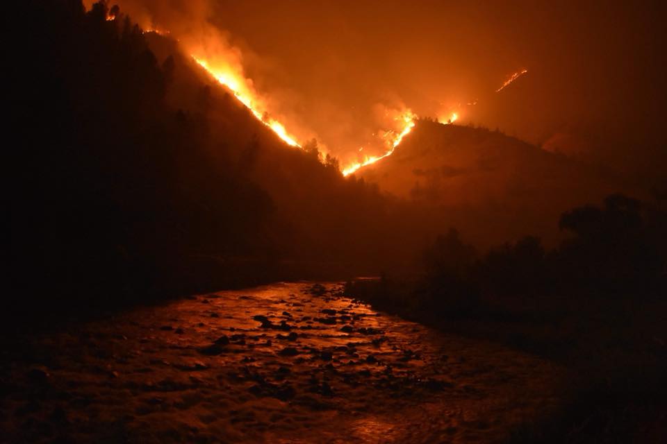
Firefighters battling a huge fire in the Sierra Nevada will face increasingly difficult conditions this week as a heat wave sets in. Officials say the Ferguson Fire has scorched nearly 53 square miles/36,102-acres of timber and brush west of Yosemite National Park, and 16 percent of its perimeter is contained Tuesday evening. The fire sent thick plumes of smoke and ash into the air, leading to very unhealthy air quality alerts in the region.

The National Weather Service says a widespread heat advisory including the fire area will be in effect Tuesday afternoon through Thursday evening for high temperatures ranging from 103 to 108 degrees, reports Discover Magazine.
More than 3,000 firefighters are battling the fire, which broke out July 13. One firefighter died the following day and six others have been injured.

And a series of other fires are also raging. The Substation Fire near Portland, Oregon, has torched 79,000 acres and forced 75 households to evacuate. It’s just one of 160 wildfires scorching southern Oregon. As of Monday morning, the fire is 92 percent contained. The Department of Environmental Quality recorded “hazardous” air in Shady Cove, Oregon Sunday morning, the worst in the United States, with very unhealthy air in Ashland, Medford and Klamath Falls.
In the contiguous United States, only Colorado has more acreage burning right now, where wildfires have already ripped through 175,000 acres, and the ensuing rains have brought mudslides along the freshly denuded landscape.

In the map above, check out the broad swath of red and orange colors through much of the western part of North America, including almost all of California and Oregon. This is where temperatures are forecast to be above normal over the next three days. This cannot be a happy map for the people who have been called in to fight the fires.
Ferguson Fire Update
July 23, 2018 / 7 PM Update
Ferguson Fire Info Line: (530) 377-6221 Media Line: (530) 377-6424
Engines: 194 Water Tenders: 45 Helicopters: 16 Crews: 91 Dozers: 52 Total Personnel: 3,311
https://inciweb.nwcg.gov/incident/article/5927/44242/
A Ferguson Fire community meeting is scheduled for Tuesday July 24th, 2018 at 11 a.m. at the Yosemite Valley Auditorium, 9035 Village Drive, Yosemite National Park, CA. 95389. Representatives from the Unified Command of CAL FIRE, the U.S. Forest Service and the Mariposa County Sheriff’s Office will present an overview of the current situation and actions underway to contain it. Parking is available along Village Drive or in the Yosemite Village Parking Area.
Firefighters are making good progress building lines to help contain the 36,102-acre Ferguson Fire. The fire stands at 16% containment with one nonresidential structure reported destroyed. Because of the efforts of crews throughout the fire area, dozens of homes have been saved.
North of the Merced River, the fire is now burning on the Stanislaus National Forest. Firefighters are making good progress with road widening and line construction using a mix of heavy equipment and hand crews in the Montgomery Gulch area. Line construction is moving steadily east toward Eagle Peak and Buena Vista.
To the south, crews completed the line from Jerseydale to the Wawona campground to protect Wawona and Yosemite National Park.
The fire was relatively inactive for most of the day because of a day-long inversion that settled in. Most of the activity was to the south near Chowchilla Mountain but also a now-contained 10-acre slop over east of Jerseydale that crews have in check.
Aerial firefighting resources being utilized include a pair of DC-10 tanker planes and a fleet of helicopters whose use has been instrumental to slow the fire’s spread.
Along the western edge of the fire area, firefighters have been successful with operations to protect structures in Jerseydale and are now mopping up areas on that edge of the fire to ensure it remains within their containment lines. Just to the north, strategic firing operations along the Sweetwater drainage are complete and have provided even more protection for communities further west.
Weather forecasts are calling for hotter and drier air throughout the week as conditions align for critical and extreme fire weather in the coming days.
Yosemite National Park remains open. For information on Yosemite National Park, go to: nps.gov/yose
or call 209-372-0200.
Mandatory Evacuations: Areas that are currently under a mandatory evacuation include:
• Incline Road from Foresta Bridge to the last BLM campground
• Jerseydale/ Mariposa Pines
• Cedar Lodge/ Indian Flat Campground
• Savage’s Trading Post
• Sweetwater Ridge
• El Portal Trailer Court
• Rancheria Flat – Government Housing
• Old El Portal
• Yosemite View Lodge
• Foresta
• Yosemite West
• Anderson Valley
• Old Yosemite Road
Advisory Evacuations: This is NOT an Evacuation Order. This is an advisement only of a potential Evacuation Order should conditions change.
• Lushmeadows Community
• Ponderosa Basin Community
• Triangle Road from Jerseydale Road to Highway 49 South including all side roads.
• Darrah Road from Triangle to Sherrod Road.
• East side of Highway 49 South from Darrah Road to Harris Road – This includes Boyer Road, Woodland Area, Wass Road, Tip Top Road.
Evacuation Center(s): New Life Christian Fellowship: 5089 Cole Road, Mariposa, CA 95338.
Road Closures: Highway 140 is closed from the entrance of Yosemite National Park to 1.5 miles West of Midpines. Incline Road, River Road from Briceburg to the gate at Railroad Flat and all Campground areas along Highway 140 closed. Hites Cove / Jerseydale Road, Foresta Road, Anderson Valley Road and Old Yosemite Road.
Animal Shelters: Small animals SPCA of Mariposa County 5599 California 49, Mariposa, CA 95338
Large animals 5007 Fairgrounds Road, Mariposa, CA 95338.
###
CAL FIRE CAL FIRE Madera-Mariposa-Merced U.S. Forest Service-Stanislaus National Forest