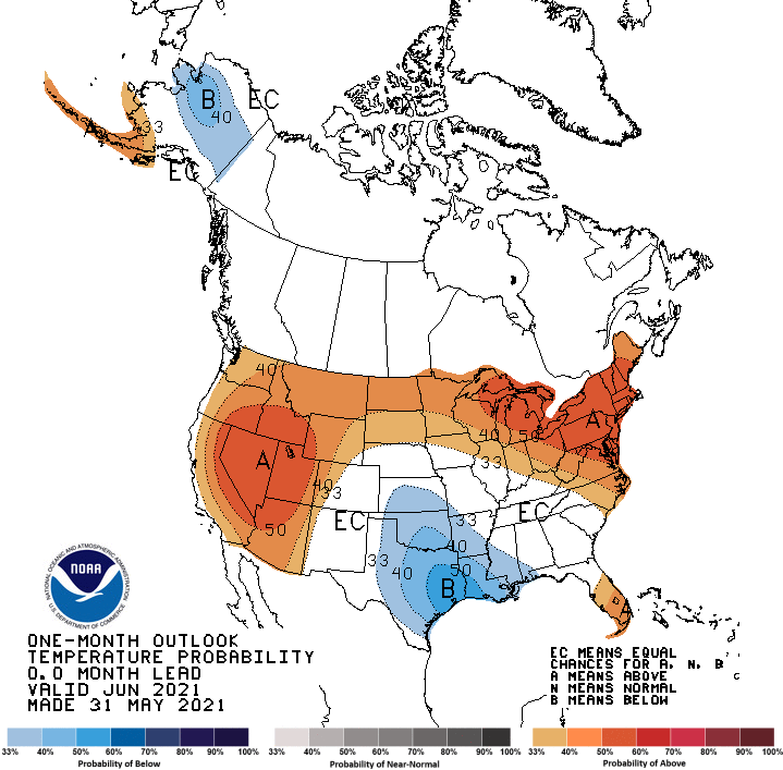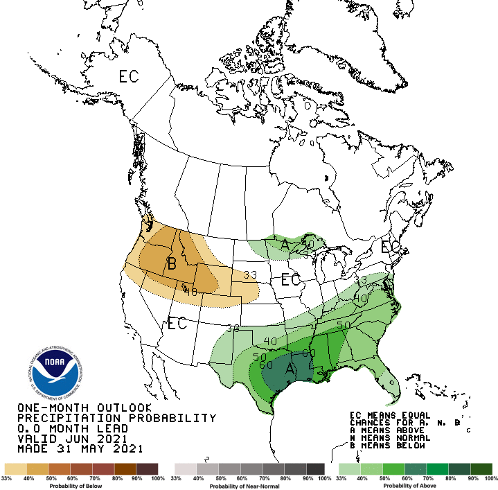
The NOAA has just released an updated 30-day outlook for June 2021. Expect warmer than average temperatures in the west, northeast, and across the northern plains and Great Lakes. For precipitation, expect the PNW to be drier than normal, and the southern High Plains to be wetter than normal.
Full text discussion below:
30-DAY OUTLOOK DISCUSSION FOR JUNE 2021

The update to the June 2021 temperature and precipitation outlooks are driven
primarily by the most recent short-, medium- and extended-range model guidance
as well as the most recently available subseasonal and monthly integrated
forecast products. The MJO has become less coherent in recent weeks and does
not play as much of a role in the updated outlook, while soil moisture
anomalies continued to inform the June temperature outlook.

Changes to the June temperature outlook are generally small overall. The
outlook continues to favor above-normal temperatures in an inverted horseshoe
pattern encompassing areas from the Southwest CONUS to the Pacific Northwest
across the northern Plains and Great Lakes to the Northeast and mid-Atlantic.
Strong ridging anticipated during much of the first half of June increases odds
for above-normal temperatures for the Northeast, Great Lakes and mid-Atlantic
compared to the mid-month outlook. Also, highest probabilities for above-normal
temperatures in the western CONUS have been shifted to the northwest and are
now focused in the central Great Basin and western Rockies where ridging and
warmer-than-normal temperatures (some potentially extreme) are likely during
the first week of June.

The most substantial change in the updated June outlook, is the inclusion of
favored below-normal temperatures for the southern Plains, lower Mississippi
Valley and western Gulf coast. The mid-month outlook did note the uncertainty
in this region and potential cooler temperatures with a forecast area of
Equal-Chances (EC) due to negative 500-hPa heights indicative of weakened
sub-tropical ridging and enhanced cloudiness and precipitation. Model guidance
through the end of May 2021 across time scales has become more clear and
increased the likelihood of the conditions described above. Substantial further
support for this addition is the recent heavy rainfall, especially for parts of
east Texas and Louisiana, which has maintained or increased anomalously wet
surface conditions across this region. Some minor changes are made in Alaska in
the update, but forecast confidence is low and only very slight tilts from
climatological odds are depicted for the state.

For precipitation, the updated June 2021 outlook illustrates some minor
adjustments in general from the mid-month outlook. Favored below-normal
precipitation remains for the northern Rockies and Pacific Northwest, but has
been removed from parts of the eastern Southwest and southern High Plains.
Model guidance favors some rainfall early in the month in this region where
normal precipitation totals are relatively low.

In addition to the potential MJO influence noted in the mid-month discussion
below, model guidance across time scales has increased confidence for
above-normal precipitation for a region from Texas to the lower Ohio Valley,
mid-South, Gulf coast, Southeast and lower mid-Atlantic. Greatest odds are for
parts of eastern Texas and Louisiana.

Other minor changes include the addition of a small region of favored
above-normal precipitation for parts of the northern Plains and upper
Mississippi Valley, but confidence is low. High uncertainty due to varying
signals in the available forecast tools across time scales in Alaska has led to
a forecast of EC for the state of Alaska in the updated June outlook.
