This post first appeared on the NASA Earth Observatory website and was written by Lindsey Doermann.
An early-November snowstorm dropped feet of snow on the plains of eastern Colorado and northeastern New Mexico and gave a boost to Rocky Mountain snowpack. While fresh powder is a common sight on the range’s lofty peaks this time of year, the accumulations measured on the plains have far exceeded monthly averages in some areas, according to news reports.
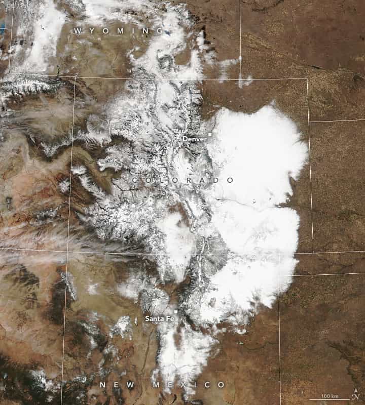
This image, acquired by the VIIRS (Visible Infrared Imaging Radiometer Suite) on the NOAA-20 satellite on November 10, 2024, shows an expansive blanket of snow across eastern Colorado and New Mexico, along with a coating of white in mountainous areas to the west. Though the preceding days’ snowfall was not the season’s first measurable accumulation in the Rockies, parts of the high country picked up significant amounts of powder, including 24 inches (60 centimeters) in the town of Breckenridge, about 50 miles (80 kilometers) west-southwest of Denver.
The storm did bring Denver’s first accumulation of the season—and it was a big one. Twenty inches (50 centimeters) fell from November 5-9, making it the city’s 11th largest snowstorm on record since 1882, according to National Weather Service records. More than 75,000 people in Colorado, mostly in the Denver metro area, lost power at the height of the storm, according to news reports.
Areas of northeastern New Mexico, including the towns of Las Vegas and Sapello about 40 miles (64 kilometers) east of Santa Fe, saw as much as 40 inches (100 centimeters) of snow. The intense wintry weather shut down some major roadways but also enabled multiple ski areas in the state to open earlier than usual.
Like much of the United States, about one-third of the state of Colorado was experiencing some level of drought at the beginning of November, according to the U.S. Drought Monitor. It remains to be seen if the recent storm will alleviate these conditions in parts of the state. Still, mountain snowpack acts as a natural reservoir, providing a steady supply of water in other seasons. As of November 11, snowpack (in terms of snow water equivalent) in the San Juan and Sangre de Cristo ranges in the southern Rockies was at least double the average for this time of year.
NASA Earth Observatory image by Lauren Dauphin, using VIIRS data from NASA EOSDIS LANCE, GIBS/Worldview, and the Joint Polar Satellite System (JPSS). Story by Lindsey Doermann.