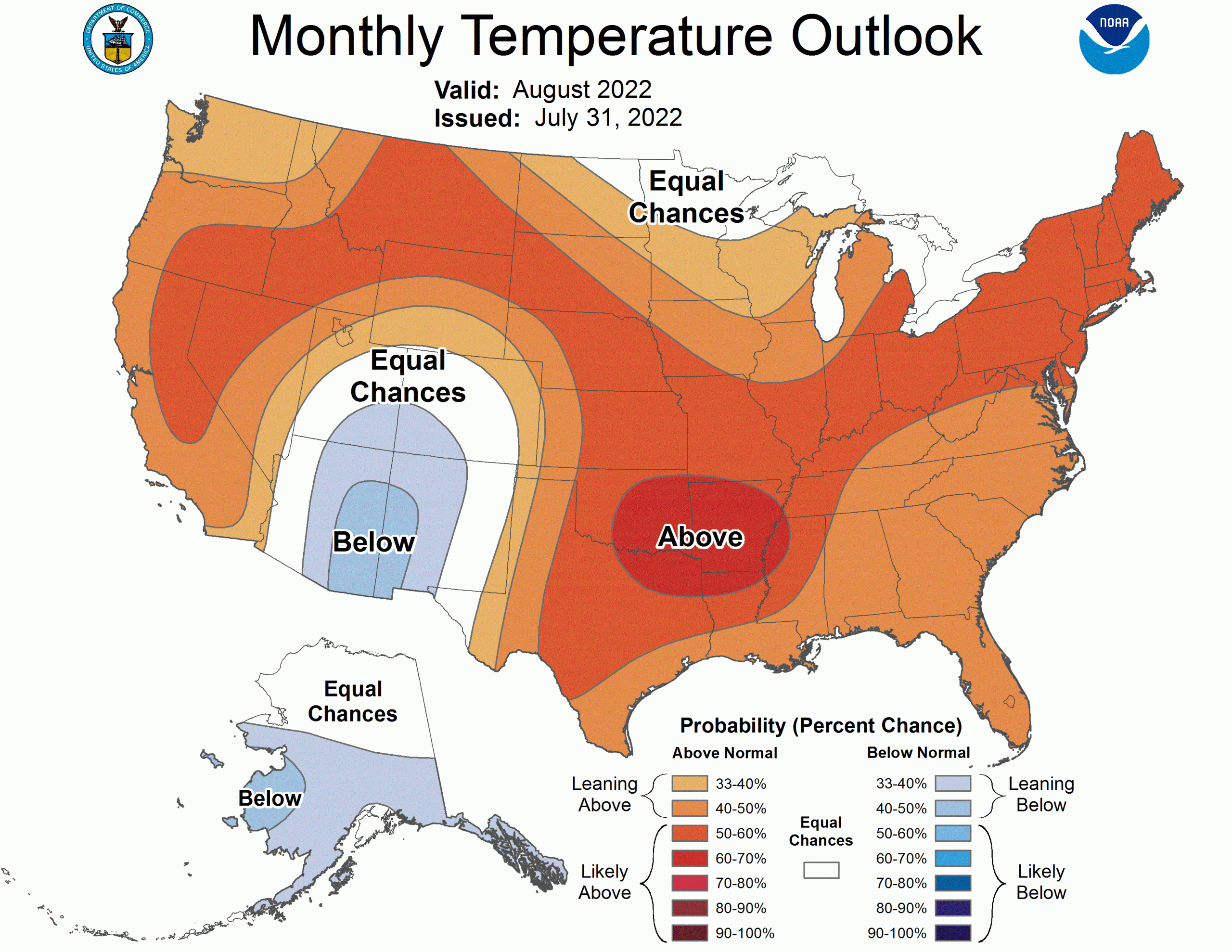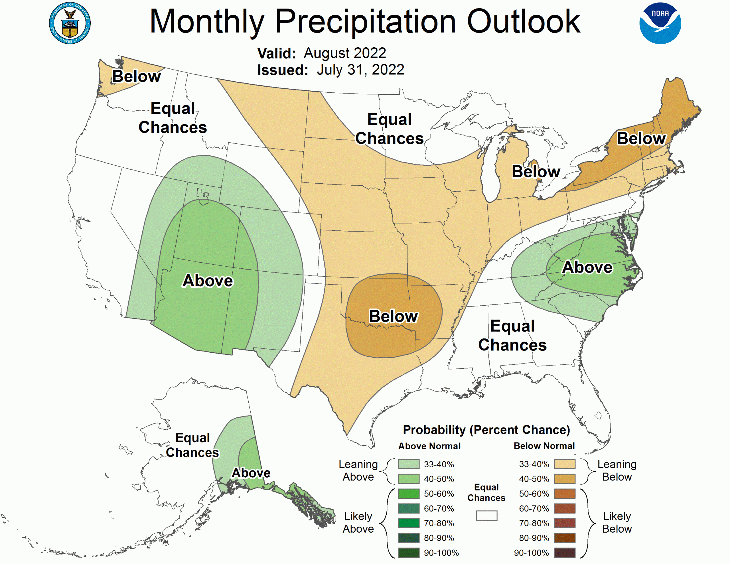
The NOAA just released its outlook for August. La Niña remains the primary remote influence on the August 2022 temperature and precipitation outlooks.
- Related: NOAA 8-14 Day Outlook: Majority of CONUS Will be Hotter Than Normal, West Wetter Than Normal
The full discussion is below:
The previous mid-month August 2022 Temperature Outlook favored enhanced above normal temperature probabilities over most of the contiguous U.S. (CONUS), and a slight tilt toward above normal temperature probabilities over the North Slope of Alaska. Short-term 6-10 and 8-14 day consolidated dynamical model forecasts as well as recent CFSv2 and GEFS monthly temperature forecasts now favor enhanced probabilities of cooler temperatures over the Desert Southwest under a robust monsoon signal. Forecasted ridging over the northern CONUS at the beginning of August is expected to persist through the Week 3-4 period given dynamical model forecasts of 500 hPa heights. This forecasted ridging supports an enhanced probability of above-normal temperatures over the northern CONUS. A weak tilt toward above normal temperature probability is favored for the Pacific Northwest, in contrast to the area of Equal-Chances (EC) of above, near, and below normal temperature previously indicated over the Pacific Northwest in the mid-month outlook. The area of EC previously indicated for parts of eastern Montana and western North Dakota in the mid-month Outlook is shifted eastward to the Upper Mississippi Valley and parts of the Northern Great Lakes following dynamical model guidance from CFSv2, as well as anomalously high soil moisture. Consolidated temperature forecasts for the beginning of August along with monthly CFSv2 forecasts support the strengthening of above-normal temperature probabilities over the mid-Atlantic (40 to 50 percent). Elevated probability of above normal temperature (60 to 70 percent) is maintained over parts of the Southern Plains and Lower Mississippi Valley in the updated August 2022 Outlook, but is shifted northward given monthly CFSv2 forecasts that favor weaker probabilities along the Gulf Coast. 6-10 and 8-14 day and week 3-4 dynamical model forecasts of 500 hPa heights depict troughing over Alaska and below normal temperature probabilities. Though in contrast to the most recent CFSv2 monthly temperature forecast which favors EC over Alaska, the forecasted persistent troughing supports a tilt toward below-normal temperature probabilities over southern Alaska. Anomalously high sea ice off the northern coast of Alaska supports the removal of the weak tilt toward positive temperatures previously indicated, and EC is now favored for the North Slope of Alaska in the updated August 2022 Outlook.
The updated August 2022 Precipitation Outlook favors a broad area of below-normal precipitation probabilities for parts of the northern, central, and northeastern CONUS. EC was previously indicated in the mid-month outlook for the Pacific Northwest and Northeast but there is consistent below normal precipitation forecasted for early August and in GEFSv12 Week 3-4 forecasts, as well as an elevated probability of below normal precipitation in recent CFSv2 monthly forecasts. This consistency along with the below-normal CFSv2 forecast supports a tilt toward below-normal precipitation over the Pacific Northwest (33 to 40 percent) and parts of the northeast (40 to 50 percent). Enhanced probability of below normal precipitation (40 to 50 percent) is favored over parts of the Southern Plains and Lower Mississippi Valley in the updated August 2022 Outlook following forecasted elevated probability of above normal temperatures, anomalously low soil moisture, and a confident forecast of below normal monthly precipitation from CFSv2. The area of EC previously indicated for parts of eastern Montana and western North Dakota in the mid-month Outlook is shifted eastward to the Upper Mississippi Valley and parts of the Northern Great Lakes following dynamical model guidance from CFSv2, as well as anomalously high soil moisture, similarly to the updated Temperature Outlook. EC is also indicated along the Gulf Coast and Florida given weak or conflicting signals from available guidance, and an area of the enhanced probability of above-normal precipitation is maintained in the mid-Atlantic. Short-term, subseasonal, and recent monthly guidance from CFSv2 and GEFS favor the probability of above-normal rainfall in a large area of the Desert Southwest related to a robust forecasted Southwest Monsoon. Enhanced precipitation may be expected in Southern California due to the chance of monsoon pulses but the probability remains weak (33 to 40 percent). Finally, an elevated probability of above-normal precipitation is maintained over eastern Alaska, but recent guidance suggests a southward shift and more coverage of the Alaska Panhandle.
