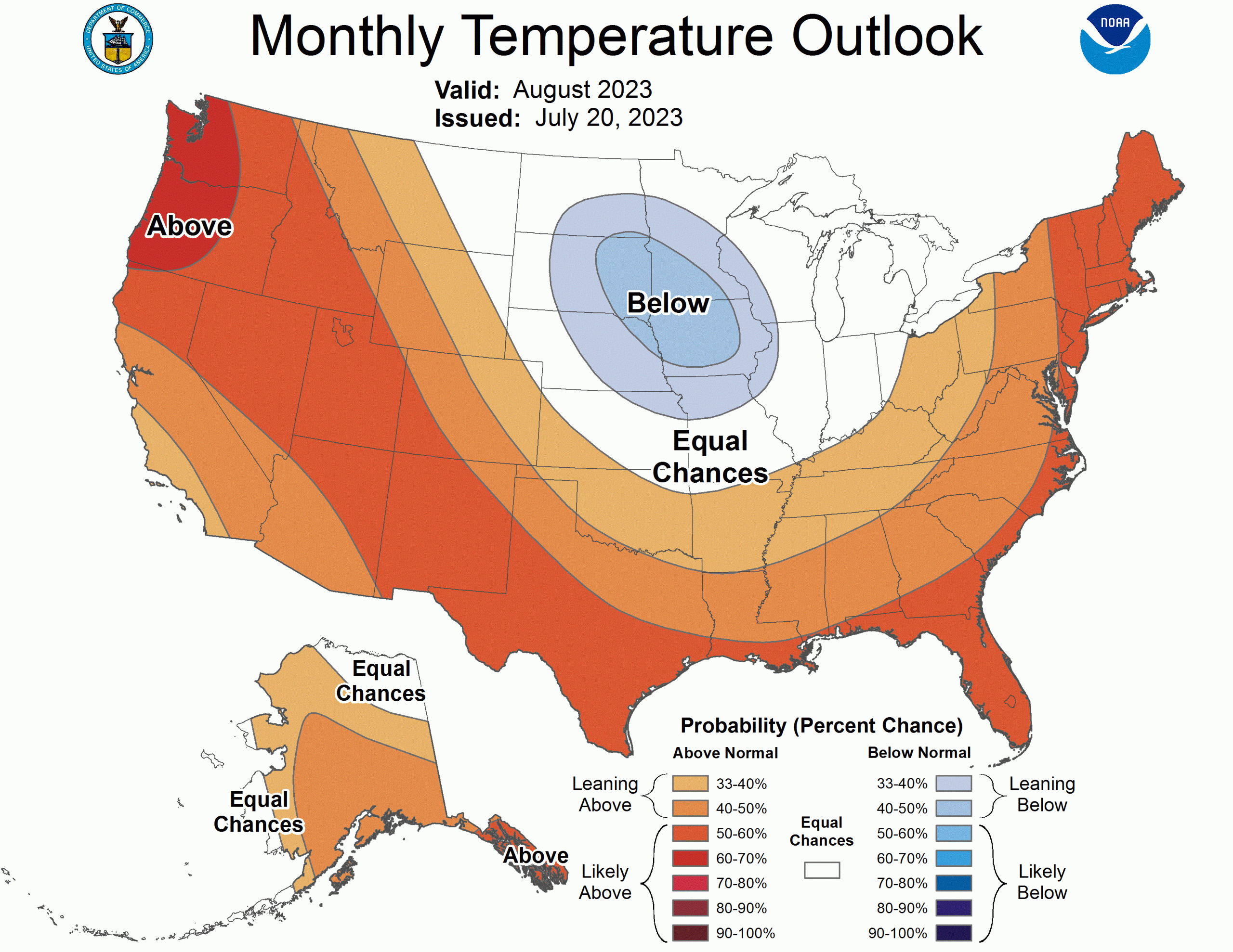
Yesterday the NOAA released its outlook for August 2023. The outlook shows that in Alaska it will be warmer than usual in most parts of the state. In the rest of the United States, it will generally be warmer than usual, with a higher chance of above normal temperatures. The Pacific Northwest has a high probability of warmer temperatures due to certain weather patterns. However, parts of the eastern Northern Plains and upper Mississippi Valley might be cooler than usual. El Niño will affect the weather in the eastern central United States, making it potentially cooler than expected. Along the Gulf and East Coasts, temperatures are likely to be above normal because the water there is warmer.
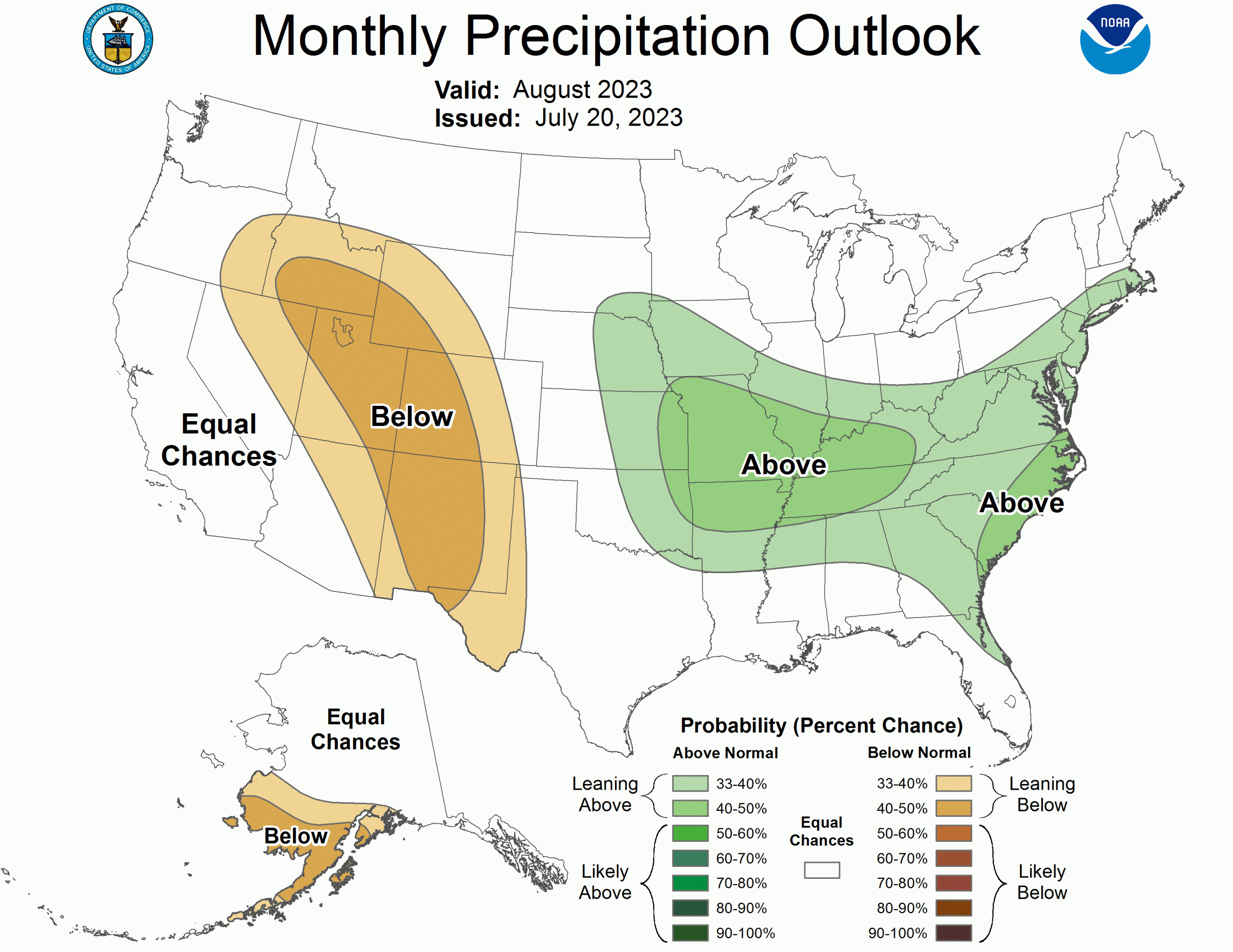
As for rainfall, in southwestern Alaska, there might be less rain than usual, especially near the coast. In southwestern Arizona, there might be more rain at the beginning of the month, but overall, the monsoon season might be less active due to El Niño. The Southwest Monsoon region, including parts of West Texas, northeastern Arizona, and areas in the Intermountain West, might have less rain than usual. However, the eastern areas of the Central Plains, central Mississippi Valley, and the Atlantic Coast might have more rain than usual. This is because of certain storm patterns. Additionally, northeastern Florida, along the Atlantic Coast, and southern New England might also experience above normal rainfall.
The NOAA discussion is below:
The August temperature outlook favors above normal temperatures over much of Alaska, consistent with dynamical model guidance and the monthly temperature consolidation. Forecasts of equal chances (EC) of above, near and below normal temperatures are indicated for the west coast of Alaska, where below average SSTs should moderate air temperatures. Equal chances (EC) is also forecast for the northeast Mainland, where tools are inconsistent. Widespread above normal temperatures are favored over much of the contiguous U.S. (CONUS), supported by the consolidation of statistical and dynamical forecast tools. Probabilities for above normal temperatures exceed 60 percent over the Pacific Northwest, due to dynamical model forecasts and dry soil moisture anomalies. Below normal temperatures are favored for parts of the eastern Northern Plains and upper Mississippi Valley. El Niño impacts favor potential troughing over the eastern central CONUS with northerly flow into this region. Statistical forecasts based on the current state of ENSO predict a larger area of favored below normal temperatures, resulting in a reduction in probabilities of above normal temperatures for much of the east-central CONUS. Above average SST anomalies along the Gulf and East Coasts increase the probability of above normal temperatures in these regions.
The August precipitation outlook favors below normal precipitation near the coast of the southwestern Alaska Mainland, supported primarily by dynamical model forecasts from the NMME and the consolidation of precipitation forecast tools. Though above normal precipitation is slightly favored in southwestern Arizona at the start of the month by the Week 3-4 Outlook, El Niño impacts and statistical forecast tools favor a suppressed monsoon for the full month of August. Below normal precipitation is favored for much of the Southwest Monsoon region from West Texas to northeastern Arizona and northward across the Intermountain West into parts of eastern Oregon and southern Idaho. Above normal precipitation is favored from eastern areas of the Central Plains across the central Mississippi Valley to the Atlantic Coast, along a preferred potential storm track and supported by the consolidation of precipitation forecast tools. Above normal precipitation is favored from northeastern Florida along the Atlantic Coast into southern New England, supported by the consolidation.

One thought on “NOAA August 2023 Outlook: Hotter and Drier Than Normal for Most of the West”