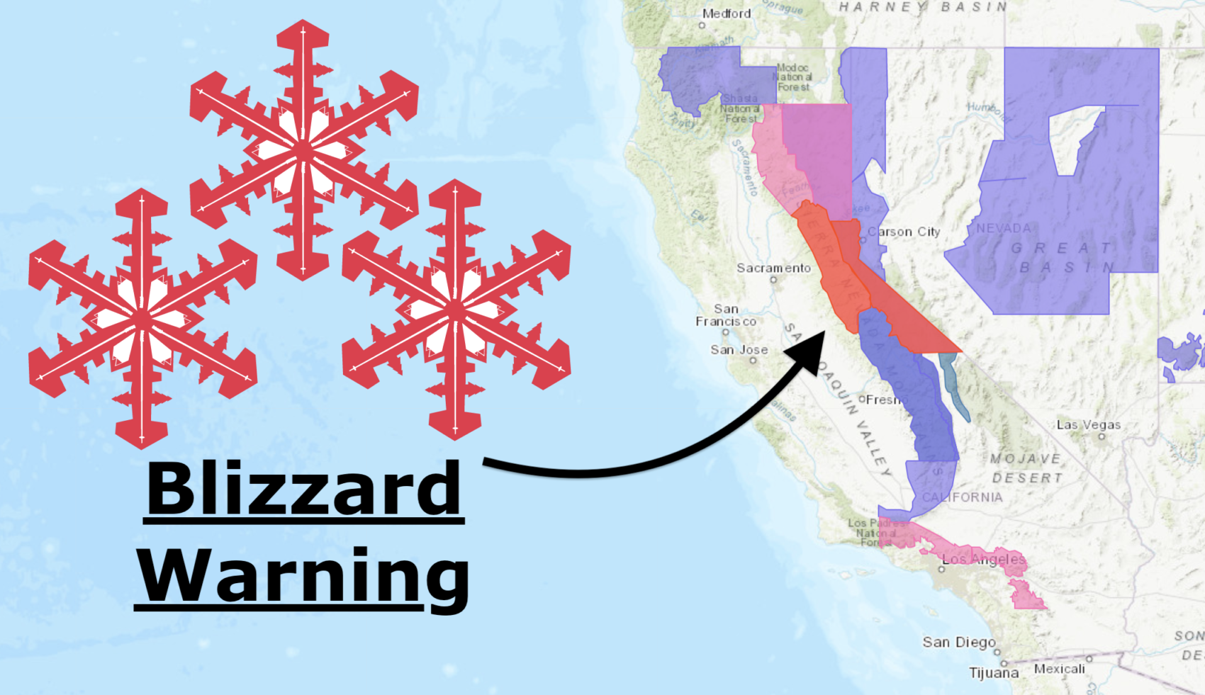
At 2:14 pm PST today, NOAA upgraded the large storm headed to California.
The Winter Storm Advisories and Winter Storm Watches that were in place this morning have been upgraded to Blizzard Warnings and Winter Storm Warnings.
NOAA is advising people to stay in their homes and not even go for a walk.
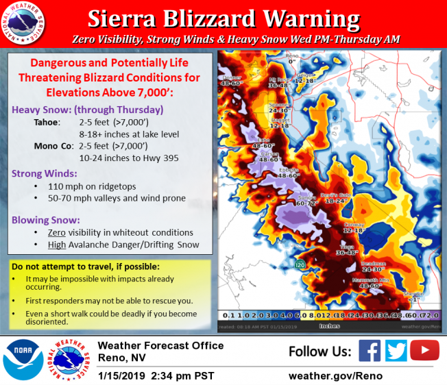
Even a short walk could be deadly if you become disoriented. – NOAA Reno, NV today
This is only the 5th Blizzard Warning that has been issued in the Sierra Nevada since 2008.
This is only the 5th Blizzard Warning from our office since 2008. They are saved for only the most serious situations. Stay home, stay safe! – NOAA Reno, NV today
This storm is big, it’s bad, and and it’s insanely snowy.
Please be ready.
A Blizzard Warning has been issued for the Sierra Wednesday afternoon through Thursday morning for elevations above 7,000’. Dangerous and potentially life threatening blizzard conditions are possible in the Sierra. Multiple feet of snowfall are expected. Strong winds will produce zero visibility in whiteout conditions along with high drifting snow. Do not attempt to travel as first responders may not be able to rescue you. Travel may already be impossible with several road closures due to heavy snow already being reported. Even a short walk could be deadly if you become disoriented. Avalanche danger will remain high through this storm. This is only the 5th Blizzard Warning from our office since 2008. They are saved for only the most serious situations. Stay home, stay safe! – NOAA Reno, NV today
NOAA is currently calling for 10-18″ of snow on Tuesday-Wednesday.
NOAA is currently calling for 24-60″ of snow on Wednesday night-Thursday.
NOAA is currently calling for 34-78″ of snow from Tuesday-Thursday.
NOAA’s forecast this morning called for 34-66″ of snow Tuesday-Thursday.
* WHAT...Tuesday afternoon through Wednesday afternoon: Moderate snow with accumulations
of 5 to 10 inches, except 10 to 18 inches west of Highway 89, are expected. Winds gusting
as high as 75 mph for ridge tops.

For Wednesday night through Thursday: Heavy snow accumulations of 2 to 5 feet above
7000 feet with blizzard conditions. Below 7000 feet, 8 to 18 inches, possibly as
much as 16 to 32 inches if precipitation remains all snow. Winds gusting as high
as 110 mph for ridge tops.
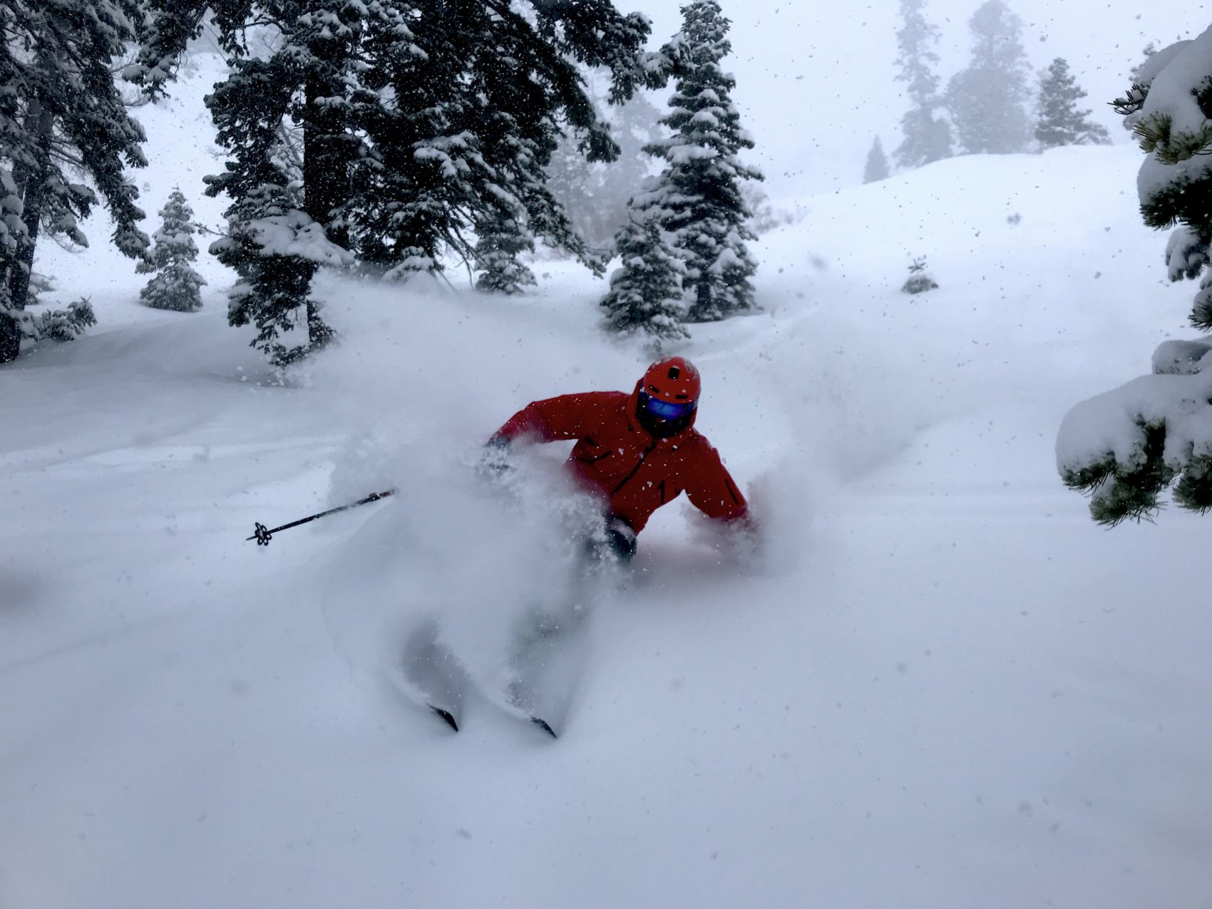
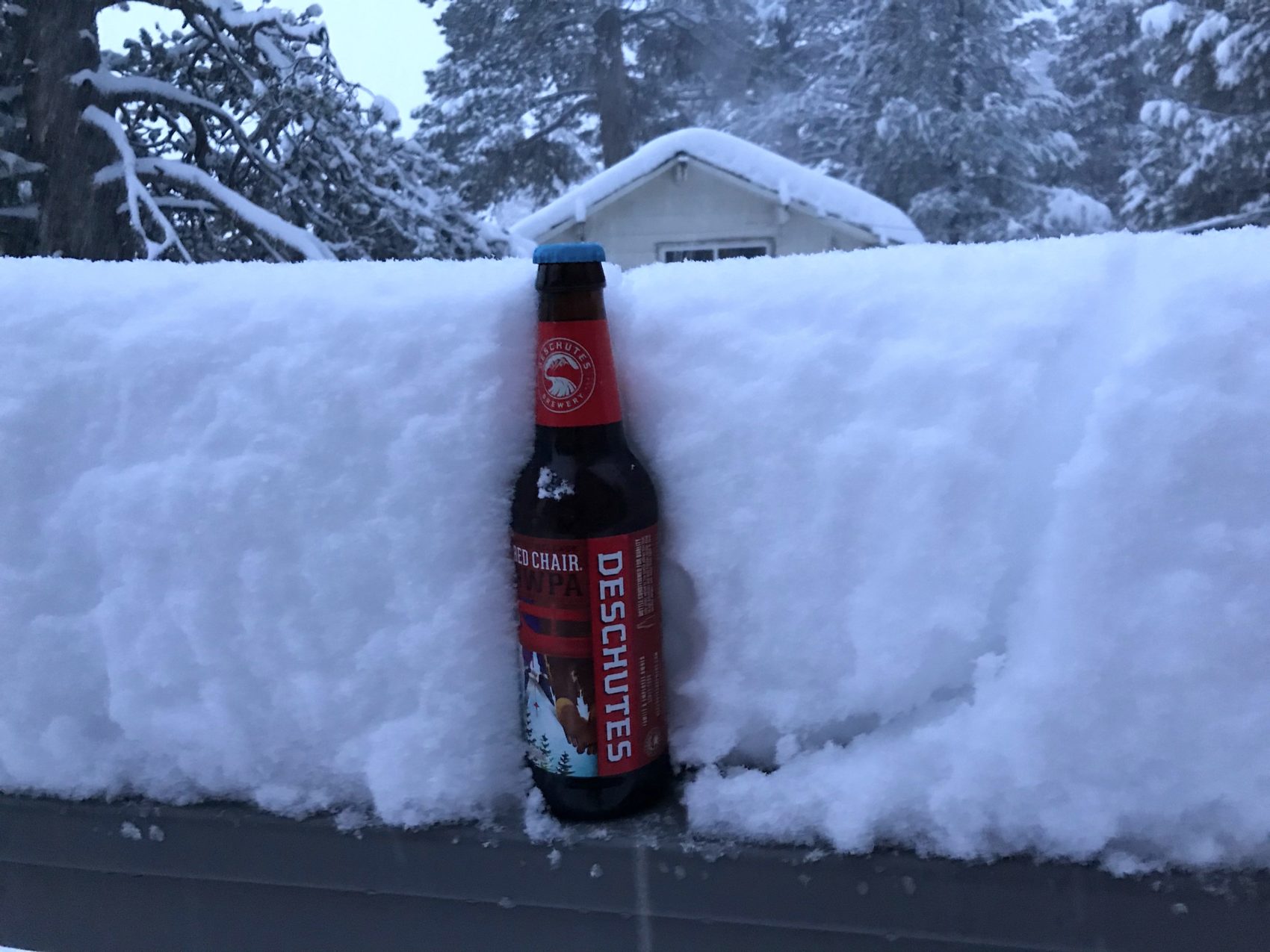
The snow is already piling up out there.
At the base of Squaw right now (5pm PST), there is 9″ of snow on our railing (height of beer bottle).
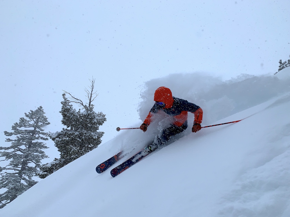
We skied Squaw from 2-4pm today and gathered these images.
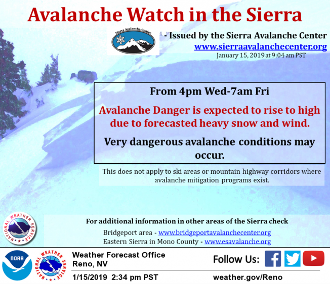
An Avalanche Watch has also been issued much of the Sierra Nevada from Tahoe to Mammoth.
An Avalanche Watch has been issued by the Sierra Avalanche Center for the Central Sierra Nevada including the Tahoe Basin from 4pm Wednesday through 7am Friday. For more details go to www.sierraavalanchecenter.org. For other areas of the Sierra mountains that are going to be effected by heavy snow. In the Bridgeport area – www.bridgeportavalanchecenter.org, and in the Eastern Sierra in Mono County – www.esavalanche.org
- NOAA Reno, NV today
Blizzard Warning
+
Winter Storm Warning
URGENT - WINTER WEATHER MESSAGE
National Weather Service Reno NV
214 PM PST Tue Jan 15 2019

Greater Lake Tahoe Area-
Including the cities of South Lake Tahoe, Truckee, Stateline,
and Incline Village
214 PM PST Tue Jan 15 2019

...WINTER WEATHER ADVISORY REMAINS IN EFFECT UNTIL 4 PM PST
WEDNESDAY...
...WINTER STORM WARNING IN EFFECT FROM 4 PM WEDNESDAY TO 4 AM PST
FRIDAY...
...BLIZZARD WARNING IN EFFECT FROM 7 PM WEDNESDAY TO 7 AM PST
THURSDAY ABOVE 7000 FEET...

* CHANGES...Blizzard conditions now expected with increased
  snowfall from Wednesday through Thursday.

* WHAT...Tuesday afternoon through Wednesday afternoon: Moderate
  snow with accumulations of 5 to 10 inches, except 10 to 18
  inches west of Highway 89, are expected. Winds gusting as high
  as 75 mph for ridge tops.

  For Wednesday night through Thursday: Heavy snow accumulations
  of 2 to 5 feet above 7000 feet with blizzard conditions. Below
  7000 feet, 8 to 18 inches, possibly as much as 16 to 32 inches
  if precipitation remains all snow. Winds gusting as high as 110
  mph for ridge tops.

* WHERE...Greater Lake Tahoe Area.

* WHEN...For the Winter Storm Warning, from 4 PM Wednesday to 4
  AM PST Friday. For the Blizzard Warning, from 7 PM Wednesday
  to 7 AM PST Thursday. For the Winter Weather Advisory, until 4
  PM PST Wednesday.

* ADDITIONAL DETAILS...Travel could be very difficult to
  impossible with periods of road closures expected. The
  hazardous conditions could impact the morning or evening
  commute. Very strong winds could cause extensive tree damage.