The NOAA just released its outlook for January 2025, giving skiers and riders the first glimpse into what the New Year might hold.
TL;DR for Skiers and Snowboarders: January 2025 Forecast
Expect a mixed bag for winter sports enthusiasts across the U.S. in January 2025. Here’s a quick rundown:
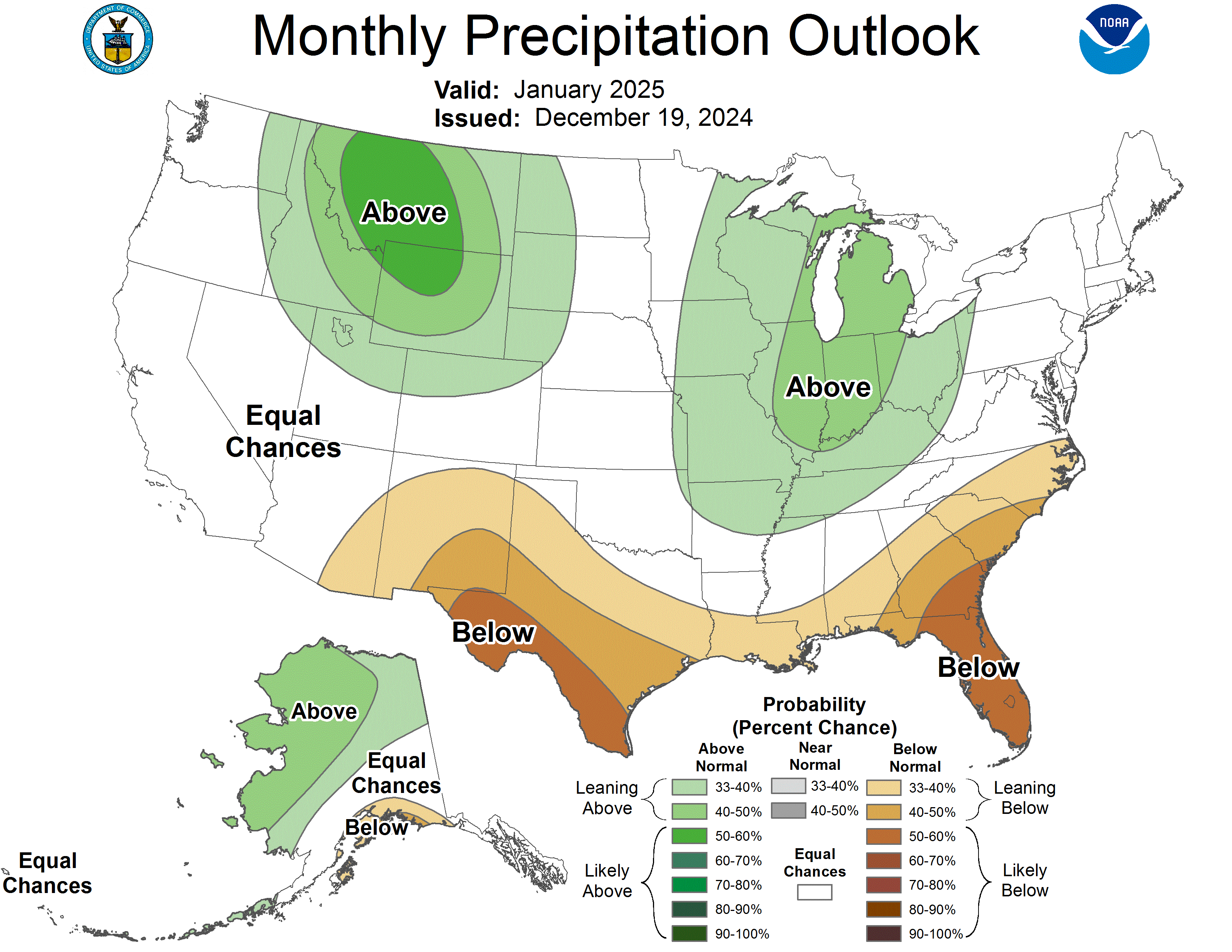
- Intermountain West and Northern Plains: Potentially good news with above-normal precipitation forecast, which could mean more snow for ski resorts in these areas.
- Southwest and Southern states: Less promising outlook with drier conditions expected, potentially leading to subpar skiing conditions.
- West Coast: Uncertain forecast, so keep an eye on local reports.
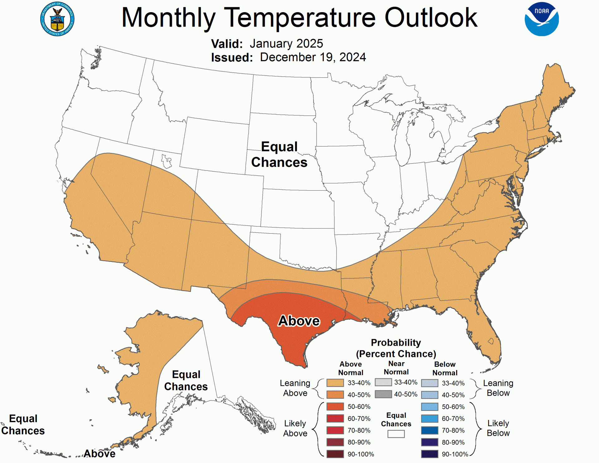
- Temperatures: Generally warmer in the South and East, more variable in the North.
Remember, this is a long-range forecast, and conditions can change. Always check local resort reports before planning your ski trips.
Below is a more in-depth summary:
A weak La Niña pattern is emerging, which could influence weather patterns across the United States in January 2025. However, the impacts are expected to be mild and variable, leading to some uncertainty in the forecast.
Temperature Outlook
The southern half of the western U.S., the Southern Plains, and the East Coast are expected to see above-normal temperatures, which is typical of La Niña conditions. However, the confidence in this forecast is relatively low due to potential weather pattern changes throughout the month.
The northern tier of states and Central Plains have an equal chance of above, near, or below-normal temperatures. This uncertainty is due to the potential for cold air intrusions, although their strength and duration are unclear.
Precipitation Outlook
The precipitation forecast shows a classic La Niña pattern. This includes:
- Above-normal precipitation for the Intermountain West, parts of the Northern and Central Plains, the Great Lakes, and interior Southeast
- Below-normal precipitation from the Southwest along the southern U.S. and parts of the coastal Southeast
The West Coast forecast is uncertain, with equal chances for above, near, or below-normal precipitation. This is due to mixed signals from various forecasting tools and the potential for periods of above-normal precipitation during winter.
Implications for Skiers and Snowboarders
The Intermountain West and Northern Plains could see favorable snowfall conditions, which might benefit ski resorts in these regions. However, the Southwest and southern states may experience drier conditions, potentially leading to less-than-ideal skiing weather.
Skiers and snowboarders should monitor local forecasts, as conditions may vary significantly due to the uncertain and potentially changeable weather patterns expected in January 2025.

Below is the text discussion from the NOAA:
Prognostic Discussion for Monthly Outlook
NWS Climate Prediction Center College Park MD
830 AM EST Thu Dec 19 2024


30-DAY OUTLOOK DISCUSSION FOR JANUARY 2025

Following a few months of weakly below normal sea surface temperatures (SSTs),
SST departures reached -0.6 degrees Celsius in the Niño3.4 region over the past
week. The current El Niño Southern Oscillation (ENSO) Alert System Status is a
La Niña watch. The extended period of weakly below normal SSTs and recent drop
to -0.6 degrees Celsius may lead to some La Niña-like impacts over the
contiguous United States (CONUS) during January and the upcoming season,
however, we expect that any impacts may be weak and variability to be high,
leading to uncertainty in some of the typical impacts. Though the Madden-Julian
Oscillation (MJO) has been a significant player in the tropics in recent weeks
and dynamical models  depict continued eastward propagation of the MJO envelope
with a slowed phase speed, the emerging La Niña has the potential to interfere
with propagation and amplitude of the MJO. Should the MJO continue into
January, this may lead to cooler than average temperatures for the northern
parts of the CONUS and Northeast, but the potential interference from La Niña
and slow phase speed add to the uncertainty. In addition to the large-scale
drivers of La Niña and the MJO, coastal or local SSTs, sea ice, and snow cover
are taken into account for this forecast where appropriate. Monthly forecasts
of temperature and precipitation by dynamical models  from the North American
Multi-Model Ensemble (NMME), Copernicus Climate Suite (C3S), and CFSv2 were
utilized in preparing this Outlook. Week 3-4 predictions for the first part of
January from GEFSv12, ECMWF, and CFSv2 and the expected transition in the
atmospheric pattern from the Week 2 period were also considered.

Enhanced ridging is forecast over most of the CONUS toward the end of December,
leading to the potential for above normal temperatures to end the year.
However, this strong ridging is expected to moderate by the beginning of
January, giving way to ridging over the West and neutral to above normal
heights over the remainder of CONUS. Week 3-4 models forecasting the beginning
of January favor weak ridging over the West and troughing over the East, though
the position, exact timing, and strength of the pattern is uncertain. Given the
atmospheric pattern leading into January and the forecasts for early January,
we expect a warm start to the month followed by a transient pattern.
Uncertainty is high due to the potential for this transient pattern,
particularly for temperatures.

The January 2025 Temperature Outlook features above normal temperatures over
the southern half of the western CONUS, Southern Plains, and the East Coast.
This pattern is fairly typical of La Niña, and reflects dynamical model
predictions that favor a La Niña like response for the month. However, given
the expected transient height pattern during the month, probabilities are
overall low for temperatures. Probabilities are enhanced over the Southern
Plains where there was the best agreement among available tools. Some models
such as the C3S suite and CFSv2 favored higher probabilities of above normal
temperatures over the Southwest, however, NMME and statistical tools that
include decadal trends  which are below normal in parts of the Southwest more
strongly favor near-normal temperatures. Given this discrepancy, a weak tilt
toward above normal temperatures is favored despite some of the model results
showing stronger probabilities in the region, which also aligns with forecast
below normal precipitation in the region. Similarly, some models indicate
stronger probabilities for above normal temperatures over the East Coast
relative to the Outlook, but given Week 3-4 models that tilt toward below
normal temperatures over the East, probabilities are again weakened. Equal
chances (EC) of above, near, and below normal temperatures are favored over the
northern tier of the CONUS and Central Plains where tools had weak or uncertain
signals, and, moreover, both MJO and La Niña may lead to cold air intrusions
into the region, though both influences are currently somewhat uncertain. In
addition, given the forecasted warm start to the month of January, it is
uncertain if periods of colder temperatures will be strong or long enough to
tilt the probability to below normal over the northern tier. Over Alaska most
models favored above normal temperatures, particularly CFSv2, and as such a
tilt toward above normal temperatures is indicated in the Outlook.

Despite the transient pattern, precipitation signals  were more consistent in
tools than temperatures. While SSTs in the Niño3.4 region just recently dropped
below -0.6 Celsius, it is possible that tools are picking up the extended
period of weakly below normal SSTs and forecasts of a weak La Niña as many of
the tools are showing a La Niña like precipitation pattern over the CONUS.  For
example, both NMME and C3S probabilistic multi-model ensemble probabilistic
forecasts show a general pattern of below normal precipitation over the
southern tier of CONUS, and above normal precipitation over the Northwest and
Great Lakes and interior Southeast, which are hallmarks of a La Niña pattern.
The January 2025 Precipitation Outlook thus resembles a La Niña like pattern,
featuring enhanced probabilities of above normal precipitation over the
Intermountain West and parts of the Northern and Central Plains, the Great
Lakes and interior Southeast, and a tilt toward below normal precipitation from
the Southwest along the southern CONUS and parts of the coastal Southeast. Over
Alaska, above normal precipitation is favored for western and northern parts of
the state, with a small area of below normal precipitation over its southern
coast. Some uncertainty exists along the West Coast where EC is indicated. NMME
and C3S favor below normal precipitation over the southern West Coast and above
normal precipitation over the northern West Coast, while CFSv2 tilts toward
below normal over the northern West Coast. Given the potential for periods of
above normal precipitation over the West Coast during winter months, EC is
favored despite some of the tools leaning toward below normal. Models and tools
also had mixed signals  along the coastal northeast and New England, and there
is potential for variability during the month due to uncertainty in storm
tracks, leading to the favored region of EC. Finally, over Alaska, below normal
precipitation is favored over its southern coast given La Niña teleconnections,
and above normal is favored over the western and northern parts of the state
given La Niña teleconnections, dynamical model agreement, and above normal
decadal trends  over the northern coast.


FORECASTER: Johnna Infanti

The climatic normals are based on conditions between 1991 and 2020, following
the World Meteorological Organization convention of using the most recent 3
complete decades as the climate reference period.  The probability anomalies
for temperature and precipitation based on these new normals better represent
shorter term climatic anomalies than the forecasts based on older normals.

An updated monthly outlook... for Jan will be issued on Tue December 31 2024

These outlooks are based on departures from the 1991-2020 base period.
$$