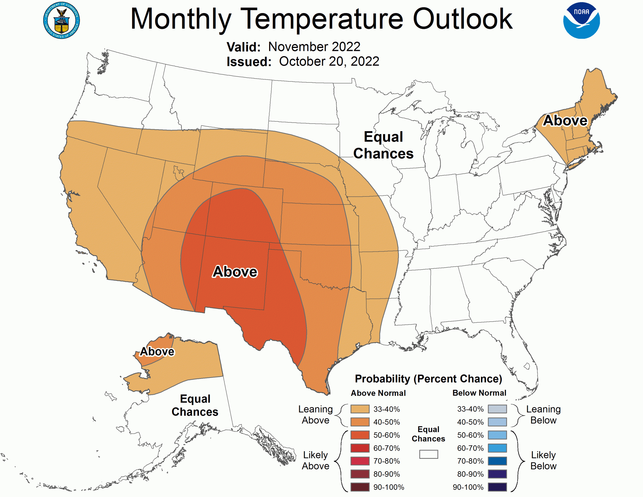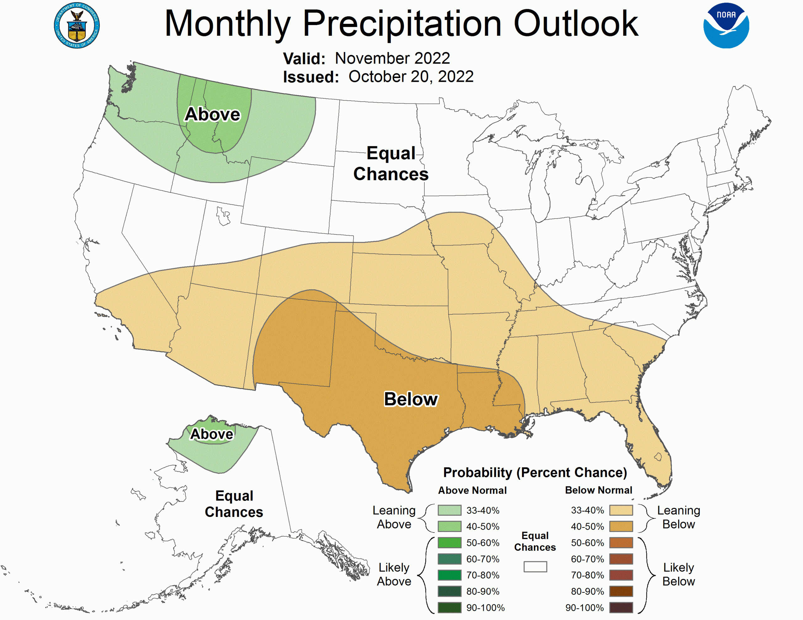
The NOAA just released its outlook for November 2022. As the month when the majority of ski resorts begin opening, we’re hoping for cold and snowy to kick off the season right.
Expect above-normal temperatures for the majority of the west and the northeast, and with the exception of the northwest, expect normal or below-normal precipitation.
The full discussion is below:
30-DAY OUTLOOK DISCUSSION FOR NOVEMBER 2022

The November 2022 Temperature and Precipitation Outlooks are prepared against a
backdrop of established La Niña conditions in the Tropical Pacific, and include
the latest statistical and dynamical model guidance, impacts from decadal
trends, and local sea surface temperature (SST) anomalies. The latest NINO3.4
weekly SST departures reached -0.8 degrees Celsius and the tropical Pacific
atmosphere remains consistent with La Niña. Following a progressive Madden
Julian Oscillation (MJO) pattern in both observations and forecasted Realtime
Multivariate MJO (RMM) indices, recent RMM forecasts from the Global Ensemble
Forecast System (GEFS) and European Centre for Medium-Range Weather Forecasts
(ECMWF) models indicate a stagnanting MJO signal. MJO did not play a
significant role in the November 2022 Outlooks. Dynamical model guidance from
the North American Multi-Model Ensemble (NMME), Copernicus model suite (C3S),
and dynamical model predictions from the Climate Forecast System version 2
(CFSv2) were considered for the outlook, as well as statistical models that
include the influence of La Niña and trend on temperature and precipitation.
Week 3-4 forecasts from CFSv2 and GEFSv12 for the early part of November were
also considered.

Week-2 dynamical model guidance favors troughing over the Western US, which is
expected to shift eastward by the Week 3-4 period (early November). By the Week
3-4 period, GEFSv12 and CFSv2 are in agreement on western U.S. ridging, while
the strength, location, and timing of predicted troughing over the eastern U.S.
is uncertain. Recent monthly CFSv2 temperature forecasts favor above normal
probabilities over the western U.S. with weaker probabilities over the eastern
U.S., likely related to the forecasted ridge and trough pattern. Though there
is good agreement among tools on above normal temperature probabilities over
much of the western and south-central U.S., monthly forecasts of temperature
from NMME and C3S favor weaker, but still above normal temperature
probabilities over the eastern U.S. A consolidation of statistical tools
indicates equal chances of above, normal, or below normal temperatures (EC)
from the eastern part of Texas to the east coast, with increased odds of above
normal temperatures in the western U.S. Given the agreement among tools on
probability of above normal temperatures over the western U.S. along with
forecasted ridging, above normal temperature probabilities are indicated for
much of the western 2/3 of the CONUS. The area of highest probabilities over
the Southwest and parts of Texas is consistent with the region of strongest
dynamical and statistical model agreement. A weak tilt toward above normal
temperatures is favored over parts of New England owing to decadal trends  as
well as consistency between NMME and C3S, however, coastal SSTA are cool or
mixed which led to a dampening of the probabilities. In contrast, uncertainty
in the strength, position, and timing of the forecasted troughing during the
early part of November, along with weak signals  from NMME, C3S, and statistical
guidance led to EC over the Great Lakes, Mid-Atlantic, and Southeast. There is
some indication of weak odds of below normal temperatures over the Pacific
Northwest when considering a statistical tool of constructed analogues of
NINO3.4 SSTA, however, this signal is not consistent in NMME, C3S, or other
available statistical tools, thus, EC is also favored for the Pacific Northwest
and northern parts of CONUS.

Temperature forecasts over Alaska are mixed, with GEFS and CFSv2 disagreeing on
the strength and positioning of troughing or ridging over Alaska in early parts
of November, and much of Alaska tilting toward EC in monthly statistical and
dynamical tools. The area of best agreement is along the North Slope of Alaska
where trends  and expected La Niña impacts tilt toward above normal
temperatures. This is further supported by warmer than normal SSTs and below
normal sea ice off the north coast of Alaska. As such, EC is favored for much
of southern Alaska in the November Outlook, with a small area of above normal
temperatures favored over the North Slope.

A generally dry pattern is favored by dynamical and statistical models over
much of the southern half of the U.S. Recent CFSv2 predictions favor an overall
dry pattern over most of CONUS, with some weakness in the western U.S. and a
tilt toward above normal precipitation in the Pacific Northwest. The dry
southern tier of CONUS is consistent with expected La Niña impacts. The area of
strongest statistical and dynamical model agreement on below normal
precipitation is from the region stretching from Arizona across Texas, and
probabilities are enhanced accordingly. A tilt toward above normal
precipitation is indicated over the Pacific Northwest, consistent with expected
impacts from La Niña and dynamical model guidance from NMME and C3S. EC is
indicated for the northern Great Plains to the Northeast given weak or
inconsistent signals  from statistical and dynamical model guidance.

Elevated probabilities of above normal precipitation are favored for the North
Slope of Alaska given expected impacts from La Niña and decadal trends . EC is
favored for the remainder of Alaska given uncertainty amongst tools.

FORECASTER: Johnna Infanti
