The NOAA just updated its outlook for October. As the month when the first resorts in North America start to turn lifts, we’re hoping for cold and snow. Is that what we’ll get?
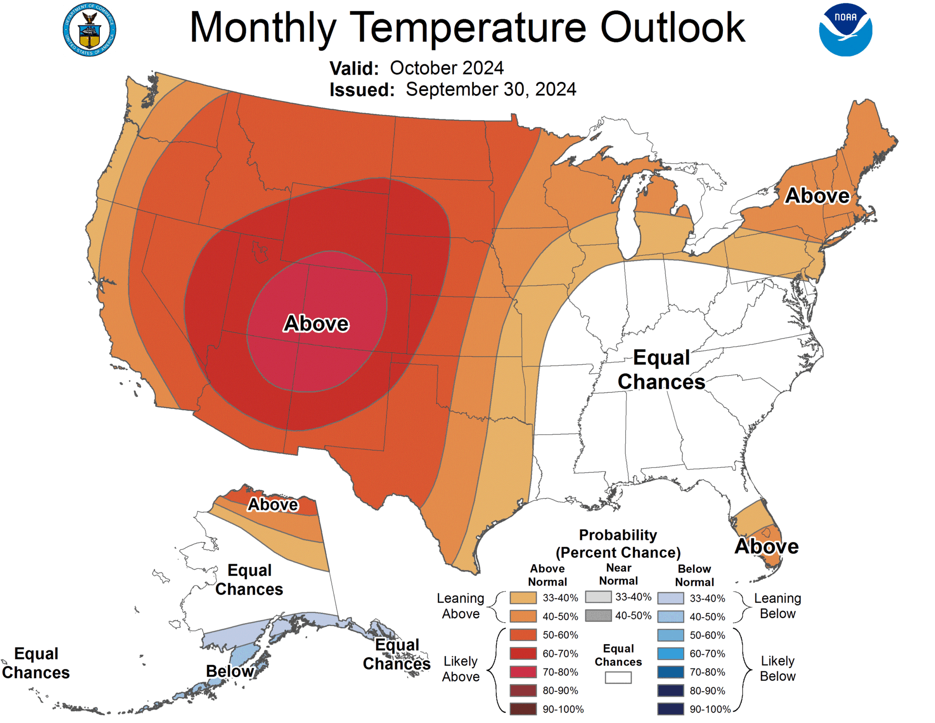
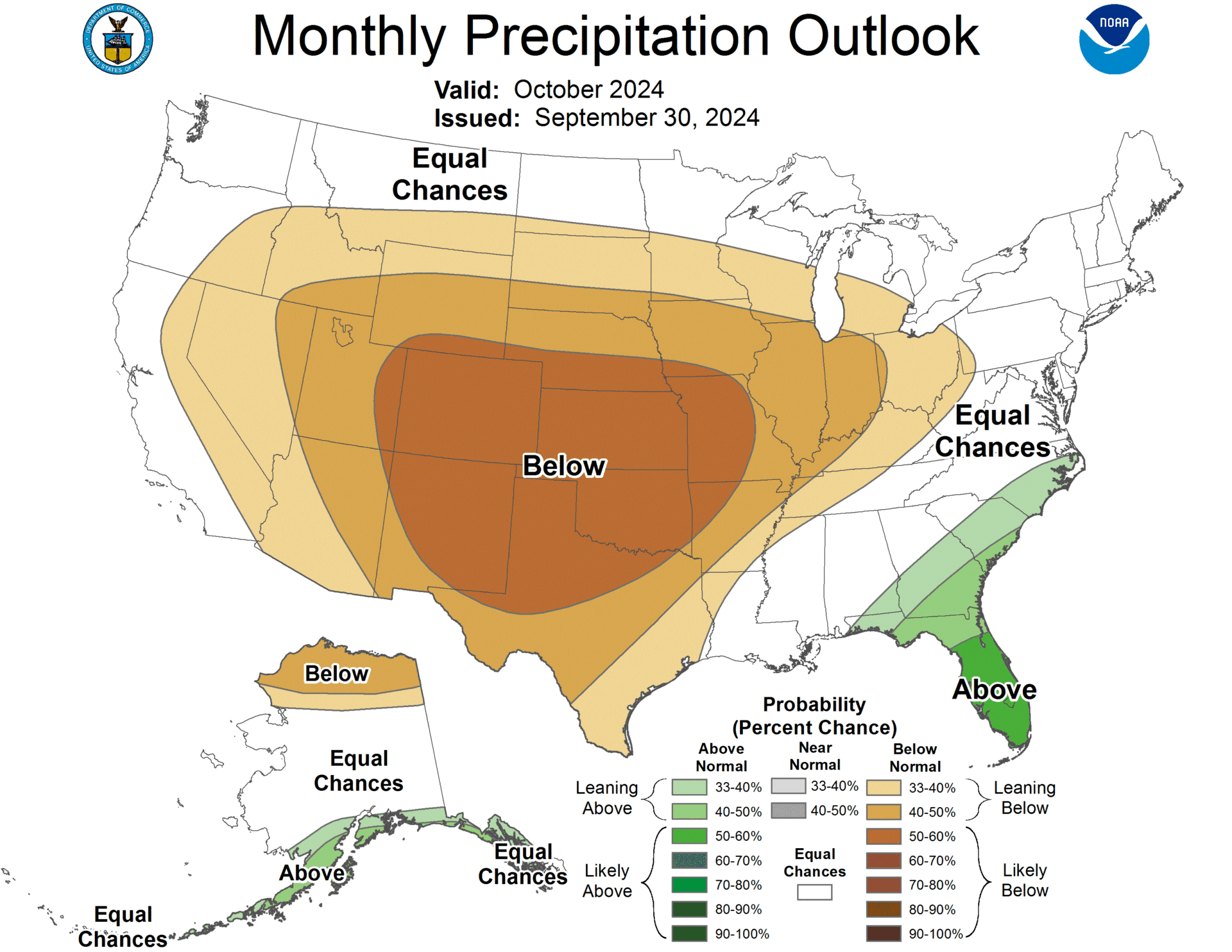
Tl;dr: The October 2024 ski forecast indicates warmer than normal temperatures and below-normal precipitation across much of the western and northern US, potentially delaying the start of the ski season in many regions.
Northwest (Pacific Northwest, Northern Rockies)
Temperature: Expect above-normal temperatures across the Pacific Northwest and Northern Rockies. This is a change from earlier forecasts, which had predicted cooler temperatures for this region.
Precipitation: Unfortunately, below-normal precipitation is likely for much of the Far West, including the Pacific Northwest and Northern Rockies. This could mean a slow start to the ski season in these areas.
Southwest (California, Nevada, Utah, Colorado)
Temperature: Above-normal temperatures are highly likely across the Southwest and central Rockies. Compared to earlier forecasts, this warming trend extends further north into Utah and Colorado.
Precipitation: The outlook for this region is quite dry. Below-normal precipitation is favored across the Southwest, including California, Nevada, Utah, and Colorado.
Northern Plains and Upper Midwest
Temperature: Warmer than average temperatures are now expected across the Northern Plains and Midwest. This is a shift from earlier forecasts that had predicted cooler temperatures for this region.
Precipitation: Below-normal precipitation is likely for the Northern Plains and the Ohio Valley. This could result in less early-season snow for ski areas like Minnesota and Wisconsin.
Northeast and New England
Temperature: Above-normal temperatures are favored for the Northeast and mid-Atlantic regions.
Precipitation: Earlier predictions of wetter conditions for the Northeast have been removed. The forecast now suggests normal to slightly below-normal precipitation for this region.
Alaska
Temperature: Northeast Alaska is likely to see above-normal temperatures, while southern Alaska has an increased chance of below-normal temperatures.
Precipitation: Southwest Alaska and the Alaska Panhandle are favored to receive above-normal precipitation. However, northern Alaska from the Brooks Range to the North Slope is expected to see below-normal precipitation.
Overall Outlook for Skiers and Snowboarders
The October forecast suggests a challenging start to the 2024-25 ski season for many regions. Warmer temperatures and below-normal precipitation across the western US could delay early-season snowfall and snowmaking efforts. However, it’s important to note that this is just the October outlook, and conditions can change as we move deeper into winter. Skiers and snowboarders should keep an eye on long-term forecasts and be prepared for potentially later opening dates at some resorts.
The full discussion is below:
30-DAY OUTLOOK DISCUSSION FOR OCTOBER 2024

The updated October 2024 temperature and precipitation outlook is adjusted by
the availability of medium- and extended-range forecast model guidance within
the validation period (i.e. first 2 weeks of October) and the most recent
available subseasonal forecast model guidance through the month of October.

The temperature outlook for monthly mean temperatures has become considerably
more clear as compared to the mid-month outlook. The previous outlook had an
above-average amount of "Equal-Chances" (EC) forecast coverage than is typical
for monthly outlooks (forecast rationale outlined below in the previous
discussion). Forecast ridging and positive 500-hPa height anomalies are
consistently forecast during the short-, medium- and extended-range time scales
for much of the western and northern CONUS. Above-normal temperatures remain
favored for the Southwest, central Rockies, Northeast, mid-Atlantic and the
Florida Peninsula as in the mid-month outlook, but odds have increased and
forecast coverage more widespread to include the Pacific Northwest, northern
Rockies, northern Plains and Midwest. Lower 500-hPa heights, frontal activity,
enhanced cloudiness and precipitation are more likely over this period in the
Southeast U.S. so EC remains forecast in this region.

Although the MJO has evolved generally as forecast in mid-September till now,
the response to the mid-latitudes (as defined through MJO composites) is not
consistent with the overwhelming medium- and extended-range model guidance
noted above. This is not overly surprising for the time of year as noted in the
mid-month discussion.

The forecast for Alaska remains largely unchanged with enhanced odds for
above-normal temperatures for northeast Alaska and enhanced odds for
below-normal temperatures (forecast coverage reduced) for southern Alaska.

For precipitation, generally only minor forecast changes are made, and the
outlook continues to be a quite dry one overall. The favored ridge-trough
pattern across the CONUS noted above supports a large area of favored
below-normal monthly total precipitation amounts stretching from the Far West
eastward across the Plains to the Ohio Valley and southward to Texas.
Probabilities are greatest for areas of the south-central High Plains and Great
Plains. The outlook is supported by short-, medium-, extended- and
subseasonal-range model guidance.

Favored above-normal precipitation remains in the new forecast from the
previous mid-September outlook for the extreme Southeast including Florida,
although for a smaller area, and for southwest Alaska. The forecast in Alaska
also now includes an enhanced likelihood of above-normal precipitation for the
south coast of Alaska and the Alaska Panhandle as well as favored below-normal
precipitation for northern Alaska from the Brooks Range to the North Slope.

An additional change in the updated outlook is the removal of the favored
wetter than normal conditions originally forecast for the Northeast CONUS -
where model guidance now opposes positive (wet) October precipitation trends .