The NOAA yesterday released its outlooks for the second half of February, both 6-10 day and 8-14 day.
Here’s an AI generated summary of the text discussion for skiers. The full discussion for those familiar with meteorology jargon is further below.
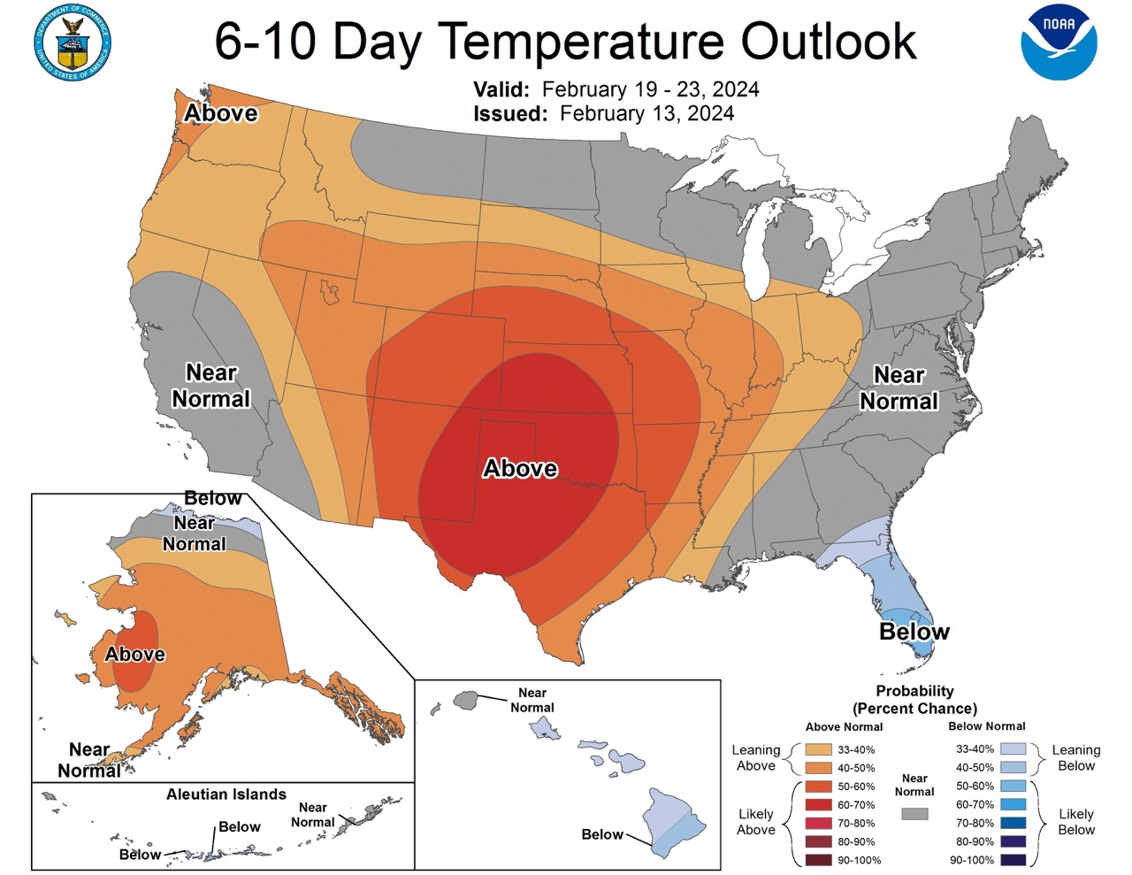
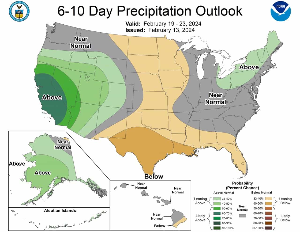
6-10 Day Outlook (Feb 19 – 23, 2024):
- Where to expect snow:
- California & Southwest: High probabilities for above-normal precipitation early on suggest good snowfall potential in ski resorts in these regions.
- Northeast: Towards the end of the period, there’s a slight tilt towards above-normal precipitation, indicating potential snowfall in this area as well.
- Where snow might be limited:
- Great Plains, Mississippi Valley, Gulf Coast: Below-normal precipitation probabilities decrease the likelihood of significant snowfall in these areas.
- Hawaii: Except for the southern part of the Big Island, where below-normal precipitation probabilities are slightly enhanced, snowfall is unlikely in Hawaii.
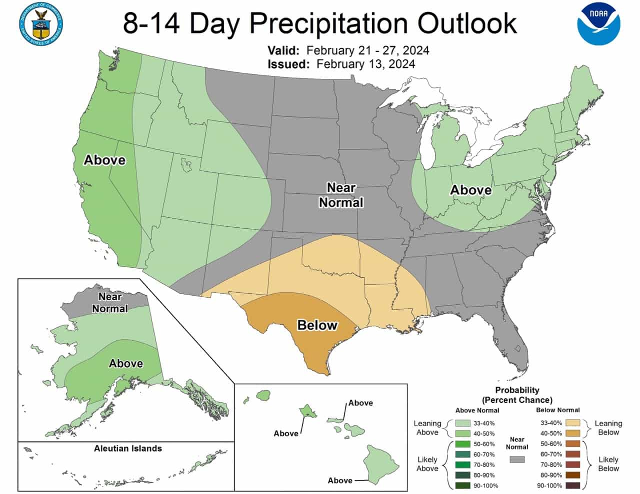
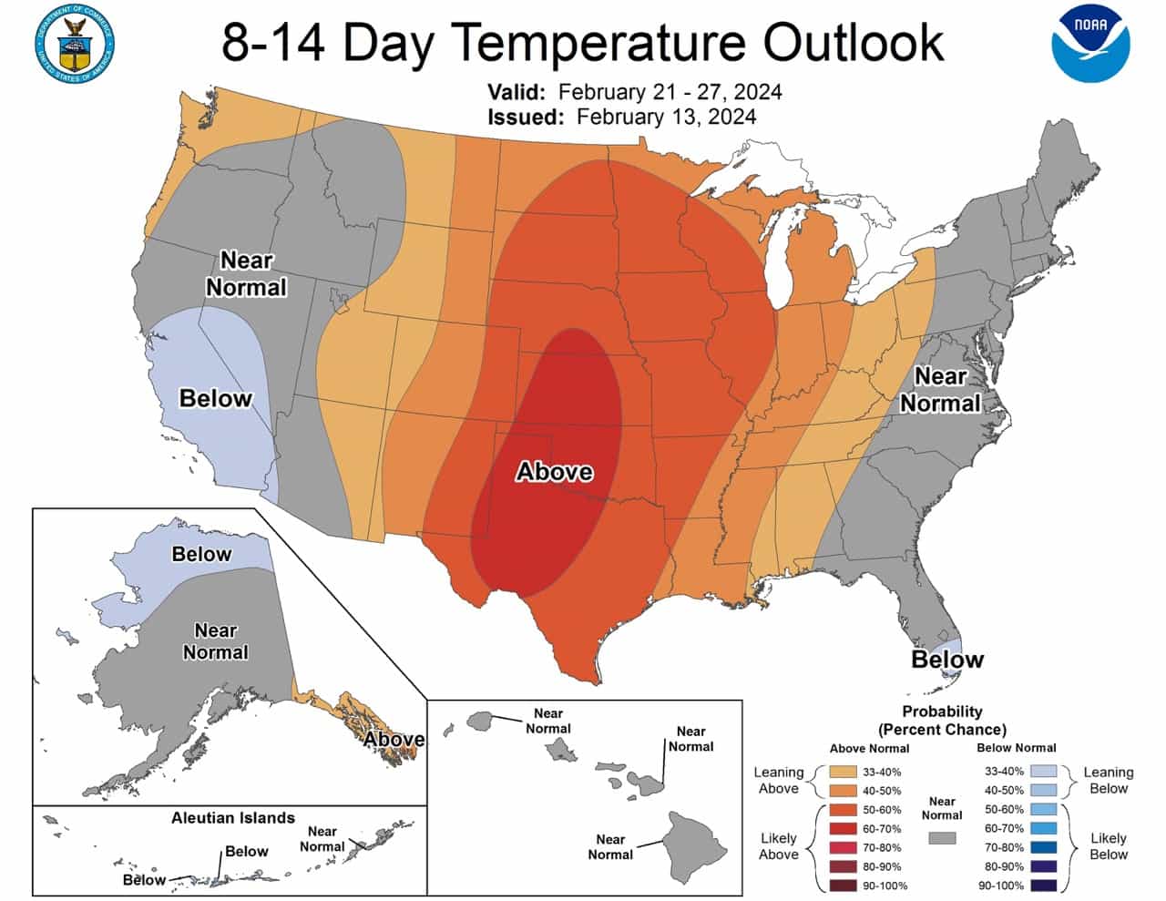
8-14 Day Outlook (Feb 21 – 27, 2024):
- Where to expect snow:
- West, especially Pacific Northwest: Elevated probabilities for above-normal precipitation suggest good snowfall potential in ski resorts in these regions.
- Ohio Valley & Northeast: Shortwave disturbance may enhance precipitation, indicating potential snowfall during this period as well.
- Where snow might be limited:
- East Coast: Near-normal temperatures with a slight tilt towards below-normal in south Florida might affect snow quality and accumulation in ski resorts in these areas.
- Southern Plains & Lower Mississippi Valley: Increased chances for below-normal precipitation decrease the likelihood of significant snowfall in these regions.
- Alaska: Although initially, above-normal temperatures are expected, as troughing shifts eastward, trending cooler might affect snow conditions in ski resorts in Alaska.
- Hawaii: Slightly elevated chances for above-normal precipitation might lead to limited snowfall, especially in higher elevations.
Prognostic Discussion for 6 to 10 and 8 to 14 day outlooks
NWS Climate Prediction Center College Park, MD
300 PM EST Tue February 13 2024

6-10 DAY OUTLOOK FOR FEB 19 - 23 2024

A transient 500-hPa geopotential height pattern is forecast across North
America during the 6-10 day period. Initially, anomalous troughing is predicted
off the West Coast of the CONUS and across southeastern Canada and the north
Atlantic, with a shortwave feature forecast to be moving off the coast of the
southeastern U.S. The West Coast trough is forecast to weaken by the end of the
period, with the 0z ECMWF, GEFS, and Canadian ensembles depicting more ridging
in the West by day-10. Models reload the troughing in the East toward the end
of the period, with the 0z ECMWF ensemble being the most robust with this
scenario. Given the model differences and transient pattern, near-normal
500-hPa heights are favored across much of the CONUS in today’s manual blend,
with larger negative height anomalies predicted near the West Coast and
northern New England. Above-normal heights are favored across the south-central
CONUS as ridging builds upstream of the trough. Across Alaska, troughing
expanding across the Bering Sea favors an erosion of the ridge initially
predicted over the Mainland. Positive height anomalies are predicted across
much of Mainland and Southeast Alaska underneath this initial ridging, with
negative height anomalies forecast over the Aleutians and extreme western
Mainland Alaska. Near- to above-normal heights are predicted across Hawaii.

Dynamical models continue to favor above-normal temperatures over much of the
CONUS during the period, although teleconnection analysis with the negative
height anomaly center over the north Atlantic favors below-normal temperatures
across the northern U.S. Compared to yesterday, probabilities of above-normal
temperatures are increased, with the highest chances (greater than 60 percent)
highlighted over parts of the Central and Southern Plains. Near-normal
temperatures are favored along the Northern Tier and along the Eastern Seaboard
consistent with the uncalibrated 0z ECMWF and Canadian ensembles, as well as to
maintain continuity with yesterday’s cooler forecast. Both the GEFS and ECMWF
reforecast tools support increased chances for below-normal temperatures across
the Florida Peninsula. Uncalibrated guidance generally favors below-normal
temperatures across the Southwest, with the GEFS and ECMWF reforecast tools
favoring above-normal temperatures likely tied to enhanced onshore flow. Given
this discrepancy, near-normal temperatures are favored for the Southwest, with
probabilities for above-normal temperatures increased across the Northwest,
consistent with higher probabilities for above-normal temperatures in the
reforecast tools. Elevated chances for above-normal temperatures are predicted
for much of Alaska as upstream troughing favors enhanced southerly flow across
the state. Probabilities for below-normal temperatures are slightly increased
across most of Hawaii, consistent with the consolidation forecast tool.

Early in the period, strong onshore flow is forecast across California and
adjacent parts of the Southwest, favoring high probabilities for above-normal
precipitation over these areas. Enhanced northerly flow in the wake of
troughing off the Southeast coast combined with ridging developing over central
CONUS favors increased chances for below-normal precipitation across the Great
Plains, Mississippi Valley, and near the Gulf of Mexico coast. Surface low
pressure may develop across the Northeast or off the coast toward the end of
the period as troughing potentially reloads across the region. The 0z GEFS is
more robust with this system, with the 0z ECMWF ensemble depicting most of the
associated moisture offshore. Given the pattern, a slight tilt in the odds
toward above-normal precipitation is highlighted over parts of the Ohio Valley
and Northeast. Troughing and enhanced southerly flow favor elevated
probabilities of above-normal precipitation across most of Alaska. Weak ridging
to the south of Hawaii favors elevated chances for near-normal precipitation
across much of the state, with the exception of the southern part of the Big
Island where below-normal precipitation probabilities are slightly enhanced.

The official 6-10 day 500-hPa height blend consists of 35% of Today's 0z GFS
Ensemble Mean centered on Day 8, 35% of Today's 0z European Ensemble Mean
centered on Day 8, and 30% of Today's 0z Canadian Ensemble Mean centered on Day
8


FORECAST CONFIDENCE FOR THE 6-10 DAY PERIOD: Average, 3 out of 5, due to
improved model agreement compared to yesterday, but still some uncertainty
given the transient mid-level pattern the degree of northward and eastward
expansion of the above-normal temperature probabilities over the CONUS.

8-14 DAY OUTLOOK FOR FEB 21 - 27 2024

The longwave 500-hPa geopotential height pattern is forecast to continue
shifting eastward during week-2. The troughing across Alaska is forecast to
build into the western CONUS, with a trend toward a more zonal mid-level flow
pattern favored east of the Rockies, with some hints of ridging developing in
the East by the end of the period. The manual 500-hPa height blend for week-2
continues to depict near-normal heights for most of the CONUS, with slightly
below-normal heights favored across parts of the Pacific Northwest and Upper
Great Lakes. Slightly above-normal heights are indicated over south Texas.
Negative height anomalies are forecast across Alaska underneath troughing
moving across the state, with near-normal heights favored across Hawaii.

As in the 6-10 day forecast, dynamical models continue to favor anomalous
warmth across much of the CONUS during week-2, especially across the Great
Plains into parts of the Midwest. As a result, above-normal temperature
probabilities are increased over much of the central CONUS. There is some
uncertainty regarding the eastward expansion of above-normal temperatures as
dynamical models suggest a reloading of the trough around the middle of the
period which would favor a break in any potential warming, with the
uncalibrated 0z ECMWF ensemble favoring increased odds for below-normal
temperatures along the Eastern Seaboard for the period as a whole. Therefore,
near-normal temperatures are highlighted across the East, with a slight tilt
toward enhanced probabilities for below-normal temperatures across south
Florida. Troughing is forecast to gradually shift eastward from Alaska, with
negative mid-level height anomalies spreading into the western CONUS by the end
of the period favoring elevated probabilities for near- to below-normal
temperatures over parts of the West. At the outset of week-2, above-normal
temperatures are favored across most of Alaska. However, as the troughing
shifts more east and the northerly component of the mid-level flow increases, a
trend toward cooler temperatures is forecast. For week-2 as a whole,
near-normal temperatures are favored for the central and southern Mainland,
with increased probabilities for above- (below-) normal temperatures
highlighted across Southeast Alaska (northern Mainland). Near-normal
temperatures are predicted across Hawaii.

Precipitation chances are forecast to diminish across the Southwest as the
week-2 period progresses, although onshore flow is forecast to increase across
the Pacific Northwest especially as troughing increases later in the period.
This results in elevated probabilities for above-normal precipitation over much
of the West from the Pacific Coast to the Rockies. A weaker mid-level flow
pattern is favored downstream, although a shortwave disturbance may enhance
precipitation over parts of the Ohio Valley and Northeast around the middle of
the period, tilting the odds toward above-normal for the period as a whole.
Across the Southern Plains and Lower Mississippi Valley, below-normal
precipitation probabilities are increased further displaced from the mean storm
track to the north. Elevated chances for above-normal precipitation are favored
for most of Alaska due to increased southerly flow, with near-normal
precipitation chances elevated north of the Brooks Range. Weak troughing is
forecast to move closer to Hawaii compared to the 6-10 day period favoring
slightly elevated chances for above-normal precipitation across the state.

The official 8-14 day 500-hPa height blend consists of: 40% of Today's 0z GFS
Ensemble Mean centered on Day 11, 40% of Today's 0z European Ensemble Mean
centered on Day 11, and 20% of Today's 0z Canadian Ensemble Mean centered on
Day 11


FORECAST CONFIDENCE FOR THE 8-14 DAY PERIOD: Average, 3 out of 5, due to
increasing confidence regarding a warmer pattern developing across the central
CONUS, with more uncertainty across the East.

FORECASTER: Thomas Collow