
NOAA is calling for wild weather for Washington through the next 5 days.
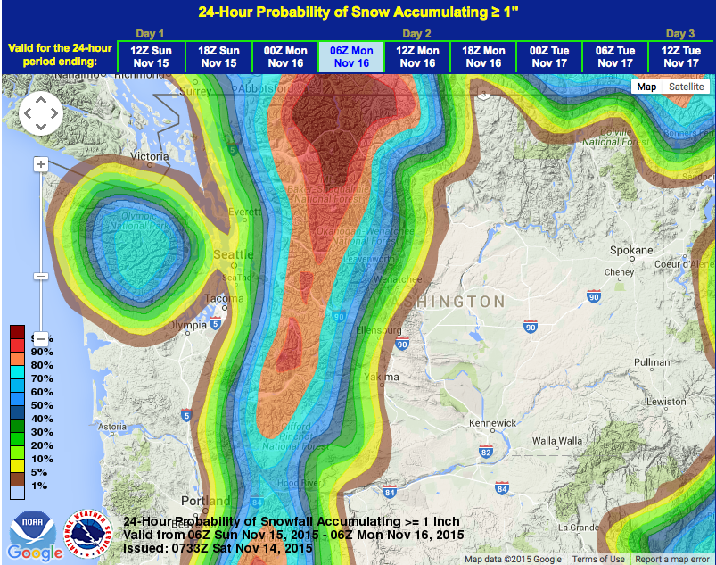
- A Winter Storm Warning is forecasting 6-18″ of Snow in North Cascade mountains in the next 24 hours with Snow Levels down to 3,000-feet
- Hurricane Ridge in the Olympic Mountains is forecast to see 20-32″ of snow which could be a “Top 5 Single Snowfall Event for Hurricane Ridge!” – NOAA
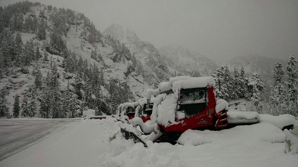
- Mt. Baker Ski Area got 24″ of snow in the past 48 hours, they have a 26″ base, they’re forecast to see up to 22″ of snow in the next 3 days, and they are hoping to open on Thursday, Nov. 19th
- Up to 95″ of Snow are forecast for 10,781′ Mt. Baker in the next 4 days
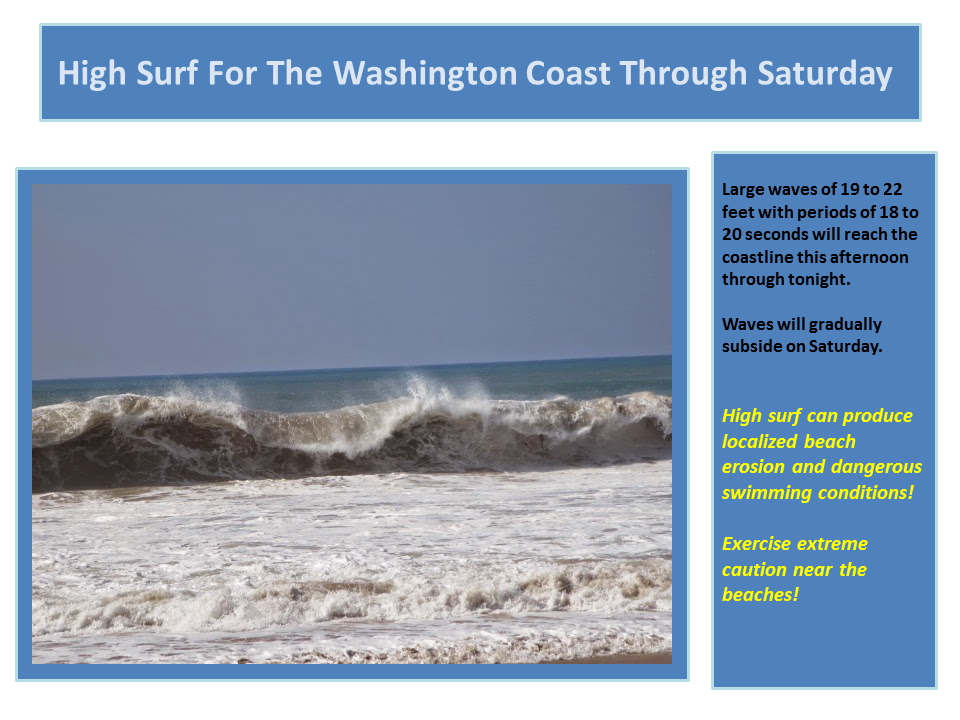
- Up to 22′ waves on the Washington coast today
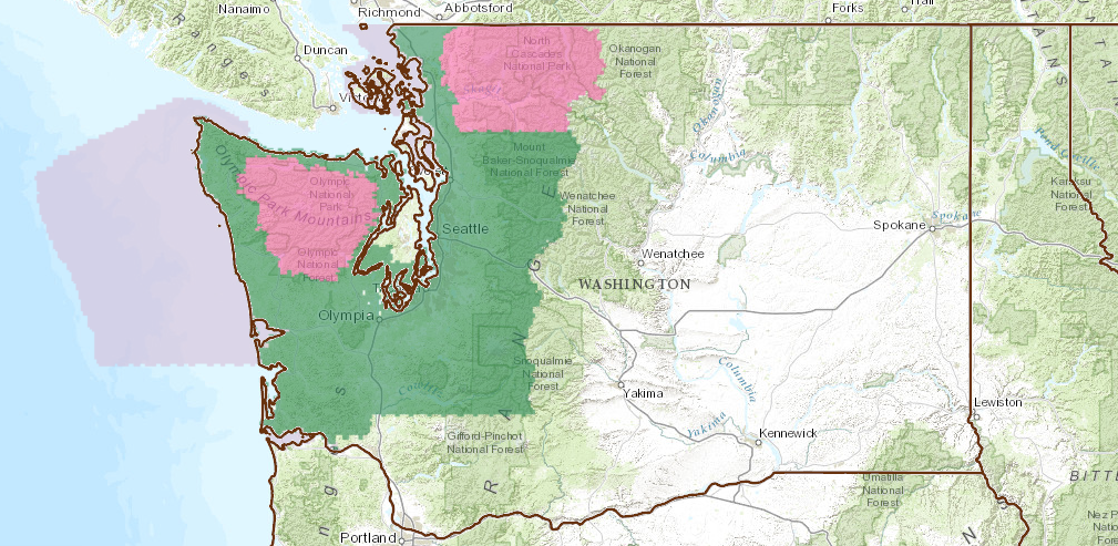
– A Winter Storm Warning is calling for 6-18″ of snow for the Cascade mountains of Washington between now and 10am Sunday.
* SNOW ACCUMULATIONS...6 TO 18 INCHES OF SNOW THROUGH SUNDAY
  MORNING. - NOAA Seattle, WA today
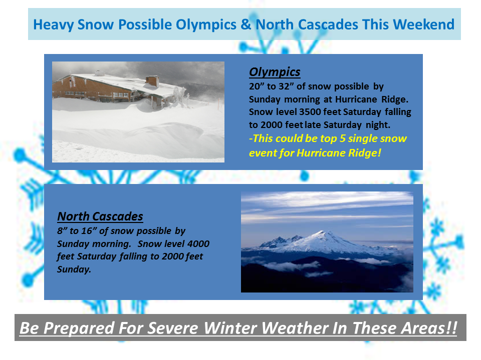
– Snow levels will begin at 4,000-4,500′ today before dropping down to 3,000′ on Sunday Morning. Snow levels will be around 4,000′ during when the bulk of the precipitation comes through.
* SNOW LEVEL...4000 TO 4500 FEET TODAY AND TONIGHT...FALLING TO
  3000 FEET SUNDAY MORNING. - NOAA Seattle, WA today
– Mt. Baker Ski Area got 24″ of snow in the past 48 hours, they currently have a 26″ base at Heather Meadows, they are forecast to see up to 11-22″ of snow in the next 3 days, and they are hoping to open on Thursday, November 19th.
Good news; we came through the rain event yesterday fairly unscathed and the temperatures dropped last night and we received 10 inches of new snow! This brings our base at Heather Meadows to 26 inches, and with NOAA forecasting up to 14 inches of additional new snow by tomorrow we could have 35-40 inches of snow at Heather Meadows by the end of the weekend.
So we will assess the conditions Monday and get an updated forecast on the warm front and make a tentative decision on a possible opening for Thursday Nov. 19th! – Mt. Baker ski area today
– 10,781-foot Mt. Baker is forecast to see up to 95-inches of snow in the next 4 days.
MODELS INDICATE THAT PRECIP WILL BE HEAVY AT TIMES OVER THE NORTH
PART TONIGHT...ENOUGH TO BRING POTENTIALLY 10-20 INCHES TO HURRICANE
RIDGE AND UP TO 14 INCHES TO THE MOUNT BAKER AREA. - NOAA Seattle, WA today
14-inches of liquid precip would equal around 14-feet of snow… 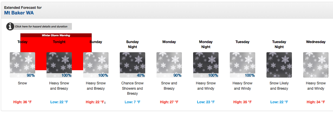

- Add it up! Up to 95″ of snow forecast for 10,781′ Mt. Baker in the next 4 days.

– Breaking waves will be 19- 25′ tall today on the Washington coast.
* COMBINED SEAS...WEST SWELL 15 TO 18 FEET AT 16 TO 18 SECONDS...
SUBSIDING TO 12 TO 14 FEET LATER TODAY. - NOAA Seattle, WA today
***
Please be careful out there this weekend and early next week, Washington. Please stay away from the coast, avoid flooded roadways, and avoid landslide prone areas. This storm is going to be very powerful and you do not want to get caught out in this one.
We’re very excited about Mt. Baker ski area potentially opening up next Thursday. We will be bringing you weekly conditions from Mt. Baker all season long.
***
WINTER STORM WARNING for WASHINGTON:
URGENT - WINTER WEATHER MESSAGE
NATIONAL WEATHER SERVICE SEATTLE WA
817 AM PST SAT NOV 14 2015

WAZ567-150015-
/O.EXT.KSEW.WS.W.0005.151114T1617Z-151115T1800Z/
CASCADES OF WHATCOM AND SKAGIT COUNTIES-
817 AM PST SAT NOV 14 2015

...WINTER STORM WARNING NOW IN EFFECT UNTIL 10 AM PST SUNDAY...

* SOME AFFECTED LOCATIONS...MOUNT BAKER HIGHWAY...RAINY PASS.

* TIMING...LIGHT SNOW WILL DEVELOP THIS MORNING. SNOW WILL INCREASE
  TONIGHT...THEN TAPER OFF ON SUNDAY.

* SNOW LEVEL...4000 TO 4500 FEET TODAY AND TONIGHT...FALLING TO
  3000 FEET SUNDAY MORNING.

* SNOW ACCUMULATIONS...6 TO 18 INCHES OF SNOW THROUGH SUNDAY
  MORNING.

* MAIN IMPACT...TRAVEL WILL BECOME DIFFICULT.
SPECIAL WEATHER STATEMENT:
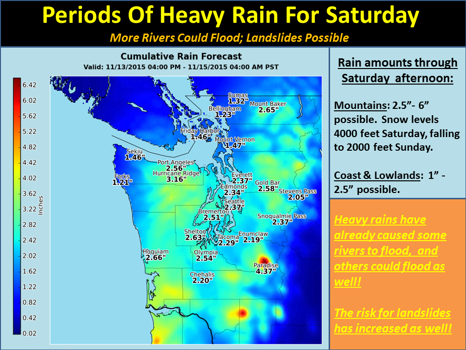
SPECIAL WEATHER STATEMENT
NATIONAL WEATHER SERVICE SEATTLE WA
405 AM PST SAT NOV 14 2015

SAN JUAN COUNTY-WESTERN WHATCOM COUNTY-SOUTHWEST INTERIOR-WESTERN SKAGIT
COUNTY-EVERETT AND VICINITY-TACOMA AREA-ADMIRALTY INLET AREA-HOOD
CANAL AREA-LOWER CHEHALIS VALLEY AREA-OLYMPICS-EASTERN STRAIT OF
JUAN DE FUCA-WESTERN STRAIT OF JUAN DE FUCA-NORTH COAST-CENTRAL
COAST-EAST PUGET SOUND LOWLANDS-BELLEVUE AND VICINITY-SEATTLE AND
VICINITY-BREMERTON AND VICINITY-CASCADES OF WHATCOM AND SKAGIT
COUNTIES-CASCADES OF SNOHOMISH AND KING COUNTIES-CASCADES OF PIERCE
AND LEWIS COUNTIES-

...INCREASED THREAT OF LANDSLIDES CONTINUING THROUGH TODAY...

RAINFALL RATES EASED UP OVERNIGHT OVER MOST OF WESTERN WASHINGTON. THE
EXCEPTION TO THIS WAS BETWEEN SNOQUALMIE PASS AND MOUNT RAINIER WHERE
UP TO 2.50 INCHES OF RAIN WAS REPORTED IN THE 12 HOUR PERIOD ENDING AT
3 AM.

UP TO ANOTHER INCH OF RAIN IS POSSIBLE FROM ABOUT SEATTLE SOUTHWARD
TODAY. SOILS ARE QUITE SATURATED WITH HEAVY RAINFALL OVER THE
LAST 60 HOURS...OVER 10 INCHES IN SOME LOCATIONS IN THE OLYMPICS.
THE ADDITIONAL RAINFALL TODAY WILL PUT EXTRA PRESSURE ON SOIL
INSTABILITY...LEADING TO AN INCREASED THREAT OF LANDSLIDES.

FOR MORE INFORMATION ABOUT CURRENT CONDITIONS...VISIT
WWW.WEATHER.GOV/SEATTLE...SELECT HYDROLOGY...AND THEN SCROLL DOWN
FOR THE LINKS TO THE LANDSLIDE INFORMATION PAGES.

TO REPORT LANDSLIDES TO THE STATE FOR TABULATION...GO TO THE
WASHINGTON STATE LANDSLIDE RISK WEB PAGE AND THE LINK FOR
REPORTING.
One thought on “Winter Storm Warning for Washington Today = 18″ of Snow for Mt. Baker Ski Area, 32″ for Olympic Mts, & Up to 95″ for Mt. Baker Proper”